Auckland
Geological Summary
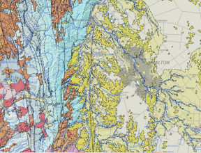
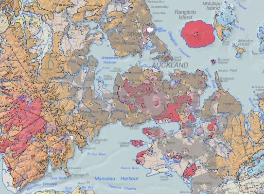
The geology of Auckland varies markedly across the city although Mesozoic greywacke basement underlies throughout, exposed in the Hunua Ranges and some Hauraki Gulf islands. Overlying Miocene and older sedimentary rock is exposed in the central isthmus and North Shore, with Miocene andesite-dominated volcanic rocks in the Waitakere Ranges. Quaternary basalt volcanoes and deposits feature in southern Auckland, and younger volcanoes and deposits are prevalent in central Auckland. Low-lying areas, particularly South Auckland, are covered in Quaternary sediments.
Maps and Information
The Auckland urban and urban fringe areas are part of a current geological mapping initiative. An updated geological map of the South Auckland (Pukekohe) area is the first in a series of maps being developed/produced for the Auckland region.
Urban Maps
Geology and Geomorphology of the Pukekohe Area
Pukekohe geological map product includes a geological map, a geomorphological map and a 3D geological model, each of which is accompanied by an explanatory text.
Geological map
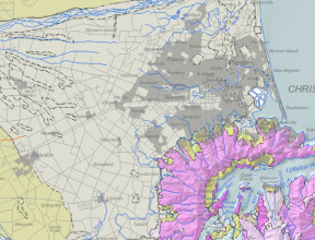
Basement rocks form the geological foundation of the entire map area but are exposed only in the eastern hill country, where they comprise Triassic–Jurassic ‘greywacke’ rocks of Waipapa Composite Terrane. An overlying succession of cover strata, in places >1 km thick, consists of Late Eocene–Early Miocene, mainly marine, sedimentary rocks of the Te Kuiti, Waitematā, and Waitākere groups. The younger parts of the geological sequence include Late Pliocene to Holocene terrestrial and shallow-marine sediments of the Takaanini Formation, and coastal dune sand deposits of the Awhitu and Karioitahi groups. Early to Middle Pleistocene basaltic volcanism produced the South Auckland Volcanic Field lava flows, cones and craters which, together with pumice-rich tephra deposits sourced from central North Island volcanoes, create the distinctive landscape of the southern half of the map area. Tectonic movements over time have produced some fault displacements of landform features, and erosion has produced many valleys and gullies whose sides have been extensively affected by landslide movement.
PDF versions of the geological map(external link) and text(external link) can be downloaded for free from the GNS Science Online Shop. GIS data (for ArcMap, ArcPro and QGIS) associated with the Pukekohe geological map can be downloaded from links included in the metadata(external link). To view the Pukekohe geological map in more detail use this link(external link).
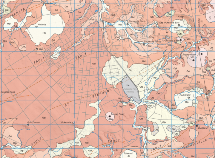
The 1:50,000-scale geological map covers 830 km2 between the southern shoreline of Manukau Harbour and the lower Waikato River. Within the map area are the Pukekohe, Waiuku, Pōkeno, and Papakura townships.
3D geological model
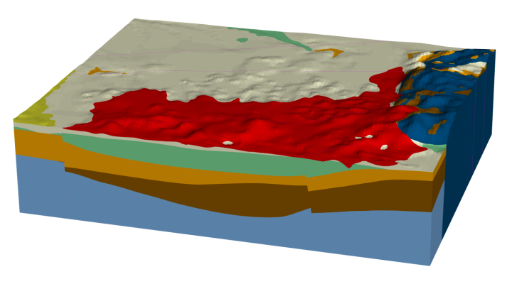
The 3D geological model provides a generalised representation of the subsurface geology extending from the southern shoreline of Manukau Harbour to the lower Waikato River valley. The main features of this 3D geological model include a representation of the underlying block-faulted Paleozoic-Mesozoic basement and basin geometry of the Pukekohe area, contacts and thicknesses of the Te Kuiti Group, Māui Supergroup (Waitematā/Waitākere groups), Ōtāhuhu Member (Takaanini Formation) and ‘undifferentiated Kaihu group’ with a depiction of the South Auckland Volcanic Field strata (Kerikeri Volcanic Group).
The 3D geological model(external link)(external link) is available for download and viewable using freely Leapfrog Viewer 3D visualisation software(external link)(external link). 2D and 3D surfaces(external link)(external link) for use in GIS or 3D modelling software are also available download. A PDF version of the explanatory text(external link)(external link) can be downloaded from the GNS Science Online Shop.
Other Information
2001/2018: QMAP 1:250 000 geological map
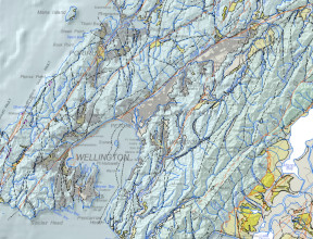
For wider and more generalised geological context of the Auckland area, a 1:250 000 geological map was printed with accompanying explanatory text. Digital GIS and image versions of the map are available on DVD. The digital version has since been updated in a national GIS dataset at that nominal scale. The underlying GIS datasets have rich feature attributes.
- Edbrooke, S.E. (compiler) 2001. Geology of the Auckland area(external link). Institute of Geological & Nuclear Sciences 1:250 000 geological map 3. Lower Hutt, New Zealand. Institute of Geological & Nuclear Sciences Limited. 1 sheet + 74 p.
- Heron, D.W. (custodian) 2018. Geological Map of New Zealand 1:250 000(external link). GNS Science geological map 1 (2nd edition). Lower Hutt, New Zealand. GNS Science.
A geological map image can be downloaded(external link) or interrogated through the geological map application(external link). For GIS users, the QMAP geological feature layers can be downloaded from GNS Science’s Web Map/Feature Service(external link).
1992: Geology of the Auckland Urban Area
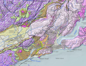
The central city parts of Auckland are covered by a 1:50000 geological map. The map was subsequently digitised into a GIS dataset in the late 1990s although the accompanying feature attributes are comparatively sparse compared with the later QMAP regional geological mapping.
- Kermode, L.O. 1992. Geology of the Auckland urban area: sheet R11(external link). Scale 1:50 000. Institute of Geological & Nuclear Sciences geological map 2. Institute of Geological & Nuclear Sciences, Lower Hutt. 1 map + 63 p.
1976-1989: 1:63 360 geological maps
These are printed maps with limited accompanying text and there are no digital equivalents.
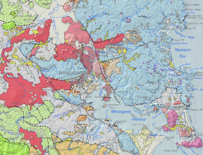
1989: Geology of the northern Auckland area (out of print)
- Schofield, J.C. 1989. Geological map of New Zealand 1:50,000 Sheets Q10 & R10 Helensville and Whangaparaoa. Lower Hutt: New Zealand Geological Survey. Geological map of New Zealand 1:50,000 Q10 & R10. 2 folded maps + 1 booklet.
1983: Geology of western Auckland area(external link)
- Hayward, B.W. 1983. Geological map of New Zealand 1:50,000 Sheet Q11 Waitakere. Lower Hutt: New Zealand Geological Survey. Geological map of New Zealand 1:50,000 Q11. 1 folded map + 1 booklet.
1976: Geology of the eastern Auckland area(external link)
- Schofield, J.C. 1976. Geological map of New Zealand 1:63,360 Sheet N48 Mangatawhiri. 1st ed. Wellington: Department of Scientific and Industrial Research. Geological map of New Zealand 1:63,360 N48. 1 folded map + booklet.
For GIS users, the layer NZL-Urban Auckland geological units based on an unpublished c. 2012 GNS Science compilation of the 1:50 000 and other unpublished maps can be downloaded from GNS Science’s Web Map Service(external link).