Wellington
Geological Summary
The geology of the cities of Wellington, Porirua, Lower Hutt and Upper Hutt are founded on Mesozoic greywacke. This basement is overlain in flatter, generally low-lying areas by Quaternary alluvial, colluvial and marine sediments, particularly in the Hutt Valley floor, Porirua basin and between Lyall Bay and Evans Bay. The Wellington CBD area has some mappable Quaternary alluvial, colluvial and marine sediment with significant reclaimed land/fill deposits along the harbour edge.
Maps and Information
GNS Science has a geological/geotechnical mapping project underway in the Wellington CBD area relating to the ground response to seismic shaking and another project mapping geomorphology for slope stability assessment. Previously completed geological maps include:
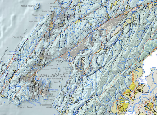
2000/2018: QMAP 1:250 000 geological map
For wider and more generalised geological context of the Wellington area, a 1:250 000 geological map was printed with an accompanying an explanatory text. Digital GIS and image versions of the map are available on DVD. The digital version has since been updated in a national GIS dataset at that nominal scale. The underlying GIS datasets have rich feature attributes.
- Begg, J.G.; Johnston, M.R. (compilers) 2000. Geology of the Wellington area(external link). Institute of Geological & Nuclear Sciences 1:250 000 geological map 10. Lower Hutt, New Zealand. Institute of Geological & Nuclear Sciences Limited. 64 p. + 1 sheet.
- Heron, D.W. (custodian) 2018. Geological Map of New Zealand 1:250 000(external link). GNS Science geological map 1 (2nd edition). Lower Hutt, New Zealand. GNS Science.
A geological map image can be downloaded(external link) or interrogated through the geological map application(external link). For GIS users, the QMAP geological feature layers can be downloaded from GNS Science’s Web Map/Feature Service(external link).
1996: 1:50 000 geological map of Wellington
The areas of Wellington City and most of Hutt City, Upper Hutt City and Porirua City are covered by a 1:50,000 geological map published in 1996 (Begg & Mazengarb 1996). This is a printed map with a comprehensive accompanying text.
- Begg, J.G.; Mazengarb, C. 1996. Geology of the Wellington area: sheets R27, R28, and part Q27(external link), scale 1:50,000. Institute of Geological & Nuclear Sciences geological map 22. Institute of Geological & Nuclear Sciences, Lower Hutt. 128 p. + 1 sheet.
For GIS users, the layer NZL-Urban Wellington geological units can be downloaded from GNS Science’s Web Map Service(external link).