DART (Deep-ocean Assessment and Reporting of Tsunami)
To improve our tsunami monitoring system, we have deployed DART stations in strategic areas in the Southwest Pacific. DART stations are deep-ocean instruments that monitor changes in pressure. They allow us to detect and measure a tsunami before it hits our shores.
Overview
Our DART network plays a critical part in keeping New Zealanders safe. Since Aotearoa New Zealand is located on the Pacific “ring of fire”(external link) - a belt of earthquake and volcanic activity in the Pacific Ocean - our coastline is exposed to tsunami waves travelling across the Pacific.
For regional and distant sources of tsunami (at least one hour’s travel time from New Zealand), DART stations are our eyes in the ocean that tell us if a tsunami has been generated and how big it might be if it reaches our shores. The DART network is particularly valuable for detecting potential tsunami-triggering events that may not be felt on the New Zealand mainland, such as such as submarine landslides and volcanic eruptions.
Not all sea floor disturbances cause tsunami. Just as important, the stations can provide rapid confirmation that no tsunami has been generated after a large earthquake or other possible trigger events.
Tsunami waves generated by local source trigger events will arrive at our coastline with little warning and could arrive within minutes of being triggered. New Zealanders should continue to follow the “long-strong get-gone” advice from NEMA when earthquake ground shaking is strong and long-lasting.
The DART network
The establishment of the New Zealand DART network is the outcome of a partnership between GNS, NEMA, NIWA and MFAT. The network is made up of 12 DART stations strategically located by tsunami scientists, to maximise the benefit of tsunami early warning advice to New Zealand and Pacific realm countries and enable improved tsunami resilience, especially from the threat of “stealth tsunamis” (Fry et al., 2020 and Powers et al, 2020).
The stations are deployed off the east and north coasts of New Zealand in the Southwest Pacific, close to the Hikurangi, Kermadec, Tonga and South New Hebrides trenches to provide early warning of tsunami waves that could reach New Zealand in less than a few hours.

The DART network is linked to GNS Science’s National Geohazards Monitoring Centre (NGMC) and Rapid Characterisation of Earthquakes and Tsunamis (RCET) automated analysis system in Wellington and provides data to the Pacific Tsunami Warning Centre (PTWC)(external link) in Hawaii and the IOC sea level monitoring website(external link) to support early and more informed warnings of tsunami threats to trans-Pacific coastal communities.
When triggered by a tsunami event far out to sea, the DART stations in the network located furthest from the New Zealand mainland can provide the NGMC with 2.5 to 3 hours warning ahead of the first waves arriving at our nearest shoreline. The DART network can then track and relay data on the tsunami to within 30 minutes of the first waves hitting the shore.
Once the first waves hit the nearest coast, they will continue to travel around our shoreline reaching other parts of New Zealand. Tsunamis are a series of waves that could take hours to arrive at their maximum height and days to fully subside from the coastline.
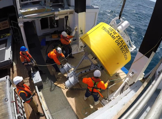
NZ DART stations - tsunami detection technology
DART data
The DART data is available on our GeoNet(external link) website and includes a map of DART station locations. You can see what the DARTs are currently measuring converted into an equivalent change in water height, what the water height would be if normal tidal changes were removed from the signal and the temperature recorded at the sensor.
The DART stations routinely capture data every 15 minutes and transmit that data to the monitoring centre at regular intervals. When a pressure change of significance is detected, the DART station triggers and will start to transmit at 15-second intervals for two hours, then hourly for up to three hours or until the water pressure returns to normal. In the absence of unusual pressure changes, the data is parcelled up and comes through as a package every six hours.
The science
DART stations detect tsunami threats by measuring changes in water pressure. They can measure pressure changes caused by less than a millimetre of sea level change in the deep ocean.
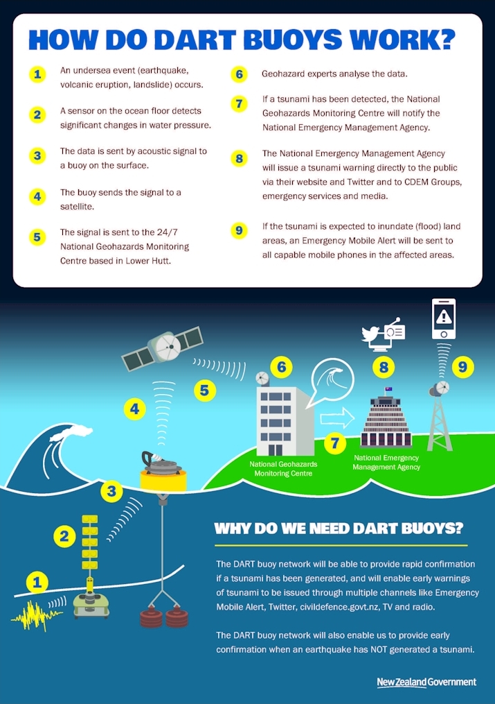
Each DART station consists of two main parts, a bottom pressure recorder (BPR) on the seafloor and a surface buoy. The BPR measures pressure created by the above water column and detects abnormally high or low changes in pressure as waves move through the water column. The BPR converts the data into wave height and relays the recorded information by sending sound waves to the surface buoy. The surface buoy transmits the information via satellite to GNS Science’s National Geohazard Monitoring Centre (NGMC) and on to global and regional monitoring partners.
The data is also sent to the GNS Rapid Characterisation of Earthquakes and Tsunamis (RCET)(external link) automated analysis system for signal post-processing and advanced modelling to determine when and how big the waves might be if they arrive at the shoreline and for how long they remain a threat to coastal communities.
How DART supports better science information for tsunami alerts
Until recently, New Zealand relied on earthquake ground shaking to warn us of impending tsunami. Our only actual tsunami measurements were from coastal tide gauges – these are useful for real-time observations but not very useful for forecasting.
DART stations are the only tried and repeatedly tested technology that confirms the generation of tsunami waves before they reach the coast. With DART stations we can provide information that supports earlier and more targeted warnings.
GNS Science’s 24/7 National Geohazards Monitoring Centre (NGMC) receives and monitors data from the DART network. When a DART station is triggered into a heightened monitoring and reporting state, the NGMC will activate the Tsunami Experts Panel to analyse the data and generate scientific information for the National Emergency Management Agency (NEMA) when appropriate. This may include more accurate information on whether a tsunami has been generated and how big the waves could be if they reach our coast.
NEMA then uses this information to assess whether a public alert is needed and, where necessary, issue improved advisories and warnings to the public. Data from the network is also used to enhance trans-Pacific forecasts, providing benefits to all countries surrounding the Pacific Ocean.
Tsunami responses supported by the DART network
Loyalty Island Earthquake and Aotearoa’s experience of the tsunami (19 May 2023)(external link)
Collaborators
The deployment of the DART network follows many years of work by GNS Science, NIWA, NEMA, and support from SAIC and contributes to a greater international tsunami monitoring effort with partners in the Pacific Tsunami Warning Centre. The DART network is funded by MBIE and MFAT.
MFAT supports tsunami warning for Pacific countries through the international development programme. The Australian Department of Foreign Affairs and Trade also supported the establishment of the Pacific DART network.
GNS Science project team
- Tsunami scientists: David Burbidge, Jean Roger, William Power, Bill Fry, Xiaoming Wang, Aditya Gusman
GeoNet project team
- Remote Infrastructure Management: Dan Whitaker, Kris O’Brien, Conrad Burton
- Science Operations Data: Jonathan Hansom, Jerome Salichon
- Data Platforms: Richard Guest, Mark Chadwick, Jesse Minty
- NGMC: Rachael Pritchard-Thorsen, Jess Fensom
- Systems Development: Sue Harvey, Jeremy Houltham
- Systems Architect: Josh Groom
- Geonet Programme: Libby Abbott
- Communications: Rachel White