Tsunami DART observations and simulation of the 2021 Raoul Island Mw 8.1 earthquake
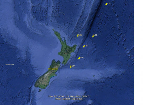
On March 4, 2021 at 19:28:31 UTC (March 5, 8:28:31 local time) a magnitude Mw 8.1 earthquake occurred offshore Raoul Island in the Kermadec subduction zone. The earthquake generated a tsunami and the tsunami was recorded by a network of New Zealand DART buoys.
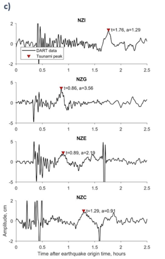
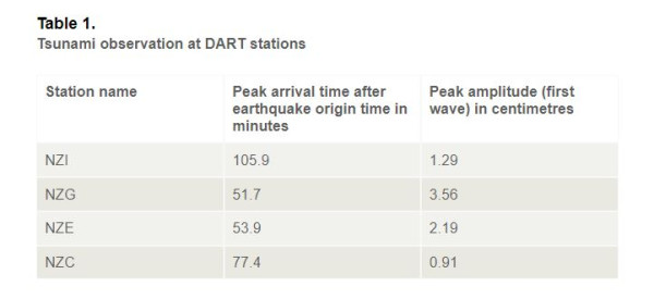
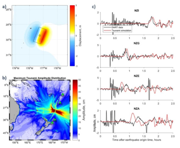
The DART data are available from GEONET. The tide and high frequency waves were removed from the original record to get the tsunami waveforms. Simulated tsunami waveforms from a preliminary fault model are compared with the observations at the DARTs. The arrival time and tsunami peak amplitude recorded at the DARTs are shown in Table 1.

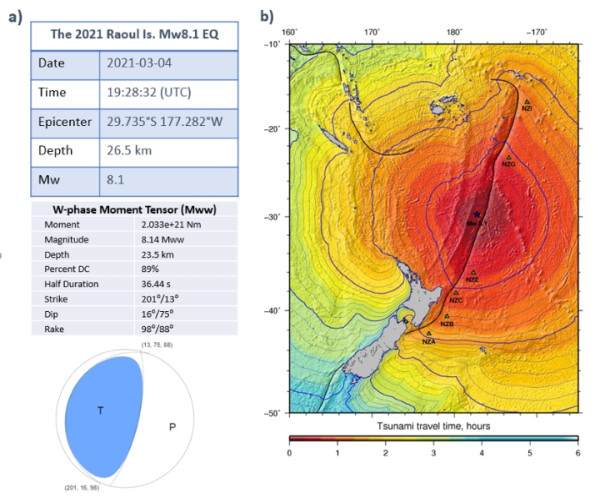
The fault model parameters for the simulation are based on the USGS W-phase moment tensor solution available from USGS (2021). Fault strike of 201°, dip of 16°, rake of 98°, and central depth of 23.5 km are used for the single fault model. Fault length of 112 km and width of 56 km based on a magnitude-to-fault-dimension relationship in Blaser (2011) were used. A slip amount of 7 m for the model is calculated from the earthquake magnitude, fault dimension, and an assumed rigidity of 4 × 10¹⁰ Nm-2. The seafloor displacement from the fault model for the tsunami initial condition (Figure 2a) is calculated using the Okada (1985) model.
A tsunami numerical model that can solve the linear shallow water equations (Satake, 1995; Gusman et al., 2010) is used to simulate the tsunami. The simulated long waves are then corrected using the Watada et al. (2014) method to include dispersion effects.
The simulated tsunami waveforms from the model are higher at all DART stations. The simulated waves also arrived earlier at NZE and NZA. A scale factor of 0.6 is applied to the simulated waveforms (and by implication to the slip model and seabed deformation) to better fit the observed tsunami peak amplitude. The simulated and observed tsunami waveforms are compared in Figure 2c. The simulated maximum tsunami amplitude distribution is shown in Figure 2b. The tsunami produced from the fault model based on the USGS moment tensor solution doesn’t fit the tsunami data without a 40% reduction in moment magnitude. The arrival time mismatch suggest that the location assumed in the current fault model might need to be revised.
-
References
Blaser, L., Krüger, F., Ohrnberger, M., & Scherbaum, F. (2010). Scaling relations of earthquake source parameter estimates with special focus on subduction environment. Bulletin of the Seismological Society of America, 100(6), 2914-2926.
Gusman, A. R., Tanioka, Y., Kobayashi, T., Latief, H., & Pandoe, W. (2010). Slip distribution of the 2007 Bengkulu earthquake inferred from tsunami waveforms and InSAR data. Journal of Geophysical Research: Solid Earth, 115(B12).
Okada, Y. (1985). Surface deformation due to shear and tensile faults in a half-space. Bulletin of the seismological society of America, 75(4), 1135-1154.
Satake, K. (1995). Linear and nonlinear computations of the 1992 Nicaragua earthquake tsunami. Pure and Applied Geophysics, 144(3), 455-470.
USGS. (2021). https://earthquake.usgs.gov/earthquakes/eventpage/us7000dflf/moment-tensor(external link)
Watada, S., Kusumoto, S., & Satake, K. (2014). Traveltime delay and initial phase reversal of distant tsunamis coupled with the self‐gravitating elastic Earth. Journal of Geophysical Research: Solid Earth, 119(5), 4287-4310.