
National Groundwater Monitoring Programme (NGMP)
This collaborative programme provides a national perspective on Aotearoa New Zealand’s groundwater quality through time.
Overview
The National Groundwater Monitoring Programme (NGMP) is a long-term collaboration between GNS Science and all of New Zealand’s regional authorities. It began as a sampling programme in 1990 with research activities starting in 2002.
It is one of GNS Science’s eight Nationally Significant Databases and Collections. The associated dataset provides unique insights and can be used for multiple purposes beyond environmental reporting.
The programme aims to
- provide an independent set of nationally consistent measurements that inform, at the national scale, on the state and trends in groundwater quality through time
- define baselines for both state and trends in groundwater quality and support environmental reporting
- associate groundwater quality changes with causes of change, such as anthropogenic influence
- identify best-practice methods and tools for sampling and monitoring as well as groundwater quality data interpretation
To achieve these objectives, the programme is organised into three components
- operations to maintain consistent and high-quality data collection
- research activities which ensure that data are being used and remain relevant
- data curation through the publicly accessible via the Geothermal and Groundwater database
The project
Monitoring is nationally consistent and long-term
The NGMP network currently consists of over 100 sites that are sampled quarterly by regional council staff. Samples are analysed by the New Zealand Analytical Laboratory facility since 1993 for a consistent suite of over 17 chemical parameters. Samples are collected according to a national, dedicated protocol (published in 1999, updated in 2006 and 2019).
Individual sample analysis integrity and inter-sample comparison are addressed by data quality assurance and checking (published in 2010, reviewed regularly), following standard operations that have been included in the NGMP since 1990.
NGMP data is used to inform national and regional environmental reporting. The first national reporting on groundwater quality was published in 2007. Since 2017, the Ministry for the Environment and StatsNZ have reported on our freshwater quality every three years under the Environmental Reporting Act 2015.
The Most Accurate Water Dating Lab in the World
The Most Accurate Water Dating Lab in the World – GNS Science in New Zealand has the world's most accurate groundwater dating facility. It is used to find the age of groundwater and glacier ice.
TE WHAKAHEKE O TE WAI (2021)
This project focuses on the groundwater systems in Hawke’s Bay’s Heretaunga catchment, and the nature of the water and how it flows through these lands.
Research ensures monitoring is future-facing
Long-term monitoring records provide unique information that can be used in a number of ways, including:
- deriving natural baselines
- providing context to pilot surveys
- investigating new research areas relevant to groundwater quality
- developing and test-driving new monitoring methods and tools
Encapsulating research within the programme is fundamental to effectively address current environmental issues, match relevant issues with optimised approaches, and assess the potential of emerging international issues to occur in New Zealand.
Providing a publicly accessible national groundwater quality database
NGMP data is curated by GNS Science within the Geothermal and GroundWater (GGW) database. The GGW database has an efficient user interface enabling search and retrieve of data using filters and maps. The database interface is in continuous development to improve feature and data access, as user needs and technologies advance.
The GGW database was designed to serve as a national data repository for fluid chemistry and is publicly accessible since 2011. In addition to the quarterly-updated NGMP dataset, the GGW database hosts other public and restricted-access datasets, such as the Bay of Plenty Geothermal Surface Feature Monitoring.
As one of our Nationally Significant Collections and Databases, the GGW database is assessed regularly against the ‘Findability, Accessibility, Interoperability, and Reusability (FAIR) principles(external link) for scientific data management and stewardship’ published in Scientific Data (2016). The provision of accurate and comprehensive metadata ensures they are discoverable via data catalogue portals and search engines. The GGW management plan was created in 2017 and reviewed in 2021.
WORLD WATER DAY 2019: WHAT IS GROUNDWATER?
Our GNS Science experts explain all you need to know - and tell you what they're doing to safeguard groundwater's future.
WORLD WATER DAY 2020: EVERYTHING YOU NEED TO KNOW ABOUT GROUNDWATER
On World Water Day, GNS Science expert Rogier Westerhoff explains why groundwater is so important to Aotearoa New Zealand.
NGMP research outputs
The programme delivers the following range of outputs:
- Peer-reviewed publications: new findings are documented and validated through external peer review.
- Collaborative best-practice guidance: long-term monitoring relies on the ability to compare different analysis through time, which requires consistency in how samples are collected and analysed.
- Tools and operation reviews: these ensure that the collected database continues to provide a long-term, national perspective on the state and trends of New Zealand groundwaters. Free applications developed through the programme support groundwater quality management and interpretation.
- Database upgrades and operations reviews: the database provides a long-term, national perspective on the state and trends of New Zealand groundwaters. Free applications developed through the programme support groundwater quality management and interpretation.
- National reporting: repeated national assessment provides a benchmark on how well groundwater resources are being managed at the national and smaller scale. These technical reports use NGMP data and are commissioned by the Ministry for the Environment to inform national reporting on freshwater.
-
Publications
Research publications
Daughney, C.J.; Morgenstern, U.; Moreau, M.; McDowell, R.W. 2023 Reference conditions and threshold values for nitrate-nitrogen in New Zealand groundwaters. Journal of the Royal Society of New Zealand, 53: doi: 10.1080/03036758.2023.2221034(external link)
Kreamer, D.; Ball, D.M.; Re, V.; Simmons, C.T.; Bothwell, T.; Verweij, H.J.M.; Mukherjee, A.; Moreau, M.F. 2021 The future of groundwater science and research. p. 503-517; doi: 10.1016/B978-0-12-818172-0.00037-2(external link) IN: Mukherjee, A.; Scanlon, B.R.; Aureli, A.; Langan, S.; Guo, H.; McKenzie, A.A. (eds) Global groundwater: source, scarcity, sustainability, security, and solutions. Amsterdam: Elsevier
Moreau, M.; Daughney, C.J. 2021 Defining natural baselines for rates of change in New Zealand's groundwater quality : dealing with incomplete or disparate datasets, accounting for impacted sites, and merging into state of the-environment reporting. Science of the Total Environment, 755(2): article 143292; doi: 10.1016/j.scitotenv.2020.143292(external link)
Moreau, M.; Hadfield, J.; Hughey, J.; Sanders, F.; Lapworth, D.J.; White, D.; Civil, W. 2019 A baseline assessment of emerging organic contaminants in New Zealand groundwater. Science of the Total Environment, 686: 425-439; doi: 10.1016/j.scitotenv.2019.05.210(external link)
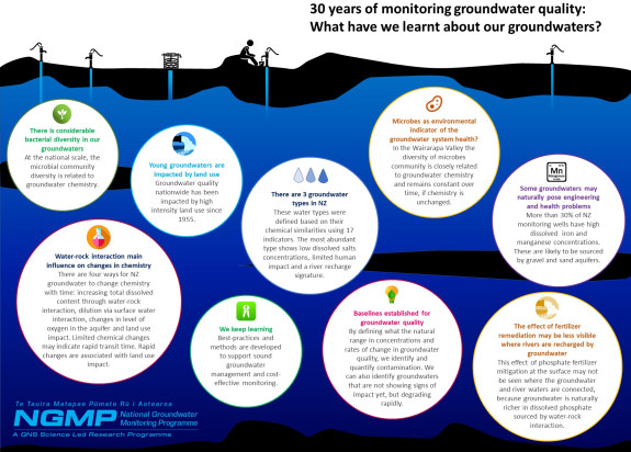
Sirisena, K.; Daughney, C.J.; Moreau, M.; Sim, D.A.; Lee, C.K.; Cary, S.C.; Ryan, K.G.; Chambers, G.K. 2018 Bacterial bioclusters relate to hydrochemistry in New Zealand groundwater. FEMS Microbiology Ecology, 94(11): article fiy170; doi: 10.1093/femsec/fiy170(external link)
McDowell R. W.; Cox N.; Daughney C. J.; Wheeler D.; Moreau M. 2015. A national assessment of the potential linkage between soil and surface and groundwater concentrations of phosphorus, Journal of the American Water Resources Association, 51(4): 992-1002; doi: 10.1111/1752-1688.12337(external link).
Sirisena K.A.; Daughney C.J.; Moreau M.; Ryan K.G.; Chambers G.K. 2014. Relationships between molecular bacterial diversity and chemistry of groundwater in the Wairarapa Valley, New Zealand, New Zealand Journal of Marine and Freshwater Research, 48(4): 524-539; doi: 10.1080/00288330.2014.923921(external link).
Sirisena K. A.; Daughney C. J.; Moreau-Fournier M.; Ryan K. G.; Chambers G. K. 2013. National survey of molecular bacterial diversity of New Zealand groundwater: Relationships between biodiversity, groundwater chemistry and aquifer characteristics. Federation of European Microbiological Society Journal: Microbiology Ecology, doi: 10.1111/1574-6941.12176(external link).
Morgenstern U.; Daughney, C. J. 2012. Groundwater age for identification of baseline groundwater quality and the impacts of land-use intensification - The National Groundwater Monitoring Programme of New Zealand. Journal of Hydrology, 456-457: 79-93.
Daughney C. J.; Morgenstern U.; van der Raaij R.; Reeves R. R. 2010. Discriminant analysis for estimation of groundwater age from hydrochemistry and well construction: application to New Zealand aquifers, Hydrogeology Journal, 18: 417-428.
Daughney C. J.; Baker T.; Jones A.; Hanson C.; Davidson P.; Thompson M.; Reeves R. R.; Zemansky G. M. 2007. Comparison of groundwater sampling methods for State of the Environment monitoring in New Zealand, New Zealand Journal of Hydrology, 46: 19-31.
Daughney C.J.; Reeves R.R. 2006. Analysis of temporal trends in New Zealand’s groundwater quality based on data from the National Groundwater Monitoring Programme, New Zealand Journal of Hydrology, 45:1 41-62.
Daughney C.J.; Reeves R.R. 2005. Definition of hydrochemical facies in the New Zealand National Groundwater Monitoring Programme, New Zealand Journal of hydrology, 44(2): 105-130.
Daughney C. J. 2003. Iron and Manganese in New Zealand’s Groundwater. New Zealand Journal of Hydrology, 42: 11-26.
Close M.E.; Rosen M.R. 2001. 1998/99 national survey of pesticides in groundwater using GCMS and ELISA. New Zealand Journal of Marine and Freshwater Research, 35(2): 205-219
Rosen M.R. 1999. The importance of long-term, seasonal monitoring of groundwater wells in the New Zealand National Groundwater Monitoring Programme (NGMP), New Zealand Journal of Hydrology, 38: 145-169.
Rosen M.R. 1998. Construction of an environmental indicators database for groundwater quality : preliminary results of a heavy metal survey of NGMP wells. p. 90-91 IN: Meteorological Society of New Zealand & New Zealand Hydrological Society joint conference to celebrate the 150th anniversary of the Otago Province : abstracts. Dunedin, NZ: Meteorological Society of New Zealand.
National best-practice guidance (collaboration)
Long-term monitoring relies on the ability to compare different analysis through time, which requires consistency in how samples are collected and analysed.
National Environmental Monitoring Standards (NEMS). (2017). Water quality: Part 2 of 4: Sampling, measuring, processing and archiving of discrete river water quality data. Version 1.0, DRAFT(released publically for review on 16 October 2017) Available from: http://nems.org.nz/documents/water-quality-part-2-rivers/(external link)
Daughney C. J.; Baker T.; Jones A.; Hanson C.; Davidson P.; Thompson M.; Reeves R. R.; Zemansky G. M. 2007. Comparison of groundwater sampling methods for State of the Environment monitoring in New Zealand, New Zealand Journal of Hydrology, 46: 19-31.
Rosen M R, Cameron S G, Taylor C B, Reeves R R. 1999. New Zealand Guidelines for the Collection of Groundwater Samples for Chemical and Isotopic Analysis. Institute of Geological and Nuclear Sciences Science Report 99/9.
Tools and operation reviews
These ensure that the collected database continues to provide a long-term, national perspective on the state and trends of New Zealand groundwaters. Free applications developed through the programme support groundwater quality management and interpretation.
Santamaria Cerrutti, M.E.; Moreau, M. 2022 Comparison of ammonia-nitrogen concentrations between unpreserved and acid-sulfuric preserved groundwater samples. Lower Hutt, NZ: GNS Science. GNS Science report 2021/27 (PDF, 1.4 MB). 15 p.; doi: 10.21420/3RJM-G633(external link)
Daughney C. J. 2010. Spreadsheet for automatic processing of water quality data(external link): 2010 update – Calculation of percentiles and tests for seasonality, GNS Science Report 2010/42. 19 p.
Daughney C. J. 2007. Spreadsheet for automatic processing of water quality data: 2007 update, GNS Science Report 2007/17. 15 p.
Daughney C. J. 2005. Spreadsheet for Automatic Processing of Water Quality Data: Theory, Use and Implementation in Excel, GNS Science Report 2005/35. 84 p.
van der Raaij R.W.; Morgenstern U. 2009. National Groundwater Monitoring Programme - review of existing sites. GNS Science internal report 2009/03. iii, 230 p., photos.
Database upgrades and operations reviews
The database provides a long-term, national perspective on the state and trends of New Zealand groundwaters. Free applications developed through the programme support groundwater quality management and interpretation.
Key dates:
- 1998 National coverage achieved
- 2007 First release of the NGMP calculator
- 2009 Age is determined at all sites
- 2010 Analytical parameters are mapped between SOE and NGMP programmes
- 2011 NGMP is shown representative of the regional SOE networks; Data becomes freely accessible through the GGW database
- 2012 Sampling frequency reviewed at all sites
- 2015 or 2016 Online help and data entry manual are deployed
- 2017 Release of a multi-filter data search tool
Moreau-Fournier M.; Daughney C.J. 2012. Dynamic groundwater monitoring networks: a manageable method for reviewing sampling frequency, Journal of Environmental Monitoring, 14(12): 3129-3136; doi: 10.1039/C2EM30624G.
Daughney C. J.; Raiber M.; Moreau-Fournier M.; Morgenstern U.; van der Raaij R. 2011. Use of hierarchical cluster 1 analysis to assess the representativeness of a baseline groundwater quality monitoring network: Comparison of New Zealand’s national and regional groundwater monitoring programs, Hydrogeology Journal, 20:1, 185-200. DOI: 10.1007/s10040-011-0786-2.
Moreau-Fournier, M.; Daughney, C.J. 2010. Procedure for checking laboratory water chemistry results prior upload to the Geothermal-Groundwater database. GNS Science internal report 2010/06. 62 p.
Moreau-Fournier, M.; Reeves, R.R.; Reshitnyk, L.; Daughney, C.J. 2010. Incorporation of New Zealand regional authority state of the environment groundwater quality data into the GNS Science Geothermal-Groundwater Database. Lower Hutt: GNS Science. GNS Science report 2010/44. 113 p.
Rosen M.R. 1999. The importance of long-term, seasonal monitoring of groundwater wells in the New Zealand National Groundwater Monitoring Programme (NGMP), New Zealand Journal of Hydrology, 38: 145-169.
National reporting
Repeated national assessment provide a benchmark on how well groundwater resources are being managed at the national and smaller scale. These technical reports use NGMP data and are commissioned by the Ministry for the Environment to inform national reporting on freshwater.
Moreau M.; Riedi M.A.; Aurisch K. 2016. Update of National Groundwater Quality Indicators: State and Trends 2005–2014, GNS Science Consultancy Report 2015/107. 42 p.
Moreau M.; Daughney C. 2015. Update of National Groundwater Quality Indicators: State and Trends December 2004-2013, GNS Science Consultancy Report 2015/16. 38 p.
Daughney C.; Randall M. 2009. National Groundwater Quality Indicators Update: State and Trends 1995–2008, GNS Science Consultancy Report 2009/145. Prepared for Ministry for the Environment, Wellington, New Zealand. 60p.
Daughney C. J.; Wall M. 2007. Groundwater quality in New Zealand: State and trends 1995-2006, GNS Science Consultancy Report 2007/23. 65p.
Research programme details
Collaborators: Auckland Council, Northland Regional Council, Waikato Regional Council, Bay of Plenty Regional Council, Gisborne District Council, Hawkes’ Bay Regional Council, Horizons, Taranaki Regional Council, Greater Wellington Regional Council, Marlborough District Council, Tasman District Council, Environment Canterbury, Otago Regional Council, West Coast Regional Council, Southland Regional Council, Tuwharetoa Trust
Duration
1998– current
Funding platform
MBIE Strategic Investment Fund – Infrastructure (2020-2021)
Status
Active
Programme leader
Magali Moreau, GNS Science
Funder
Funding: Ministry of Business, Innovation & Employment