


Groundwater | Strategic Science Investment Fund
The Groundwater Strategic Science Investment Fund (SSIF) programme is developing advanced hydrogeological maps, methods and models to support sustainable and economic use of Aotearoa New Zealand’s groundwater resources. These maps and models will be a first for New Zealand.
Overview
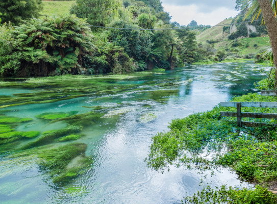
Groundwater resources around the world and in New Zealand are under immense pressure. Resources are depleting and water quality is deteriorating. On top of this, climate change, population growth and current and past land use activities are expected to put additional stresses on our freshwater resources now and in the years to come.
The impacts of contamination, over-allocation and climate change are of growing concern but cannot be adequately assessed at present due to a lack of fundamental knowledge of many New Zealand aquifers.
The Groundwater SSIF research programme aims to address these knowledge gaps.
World Water Day: What is Groundwater? (2019)
Why is groundwater important and why is it under threat? To mark #WorldWaterDay, our GNS Science experts explain all you need to know and tell you what they're doing to safeguard groundwater's future.
What needs to be done?
We need to know what the locations and properties (structural, hydrogeological and fluid) of New Zealand's aquifer systems are so that we can, for example:
- Improve ‘downstream’ maps and models (e.g. for groundwater flow or climate change impact predictions)
- Take a consistent groundwater stock account to do things like support national environmental reporting
We need to identify how our research findings can better guide water policy implementation so that we can, for example:
- Identify sustainable and equitable management solutions
- Develop new and innovative approaches to groundwater management
- Support kaitiakitanga and iwi co-management solutions
We need to know more about the fluxes of water and key substances into, out of and through New Zealand’s aquifers so that we can, for example:
- Quantify lag time of nutrients from farms to waterways
- Understand the connection between our groundwater systems and rivers, lakes and wetlands
- Validate groundwater flow and transport models
We need to assess how human activities, climate change and other pressures have (and will) affect New Zealand's groundwater resources and receiving environments (e.g. springs, rivers and lakes) so that we can, for example:
- Determine the current and future impacts of climate change and land use change on groundwater quality and quantity
World Water Day: Everything you need to know about groundwater (2020)
What is groundwater, why is it under threat and what can we do to protect it? On World Water Day, GNS Science expert Rogier Westerhoff explains why groundwater is so important to Aotearoa New Zealand, and outlines the work that GNS Science is doing to map
Key projects
The current Groundwater SSIF research programme is funded by MBIE through the MBIE Strategic Science Investment Fund and focuses on:
- National aquifer mapping and characterisation by system
- Advanced framework for groundwater modelling
- Databases, data access, data outreach
- Impacts on groundwater
- Translating groundwater science into policy
- Groundwater age and contaminants
National aquifer mapping and characterisation by system
There is a wealth of existing information and knowledge within councils, GNS Science and other open-file sources about our aquifers – but it needs to be brought together with new data into a nationally significant baseline reference geospatial dataset.
This means that for the first time, all current understanding of our geologically complex aquifer systems will be in one place. This dataset will provide a consistent template for evaluating aquifers according to eight principal hydrogeological system types – coastal basin, coastal volcanic, coastal independent, inland basin, inland volcanic, inland river valley, basement infill and basement.
Better predictions of how our groundwater systems will respond to changing land use and climate will need better modelling. To make this happen, we need fundamental underpinning 3D data that is nationally consistent and scalable, and incorporates a wide variety of understanding between systems.
These data will give us the capability to monitor national groundwater volumes at a robust enough level to detect trends and provide a framework to use information from well-studied catchments to support decisions and future research in under-studied catchments.
Advanced framework for groundwater modelling
Water managers need tailored guidance, models and tools to make effective management decisions and evaluate the impacts of changing land use and climate on groundwater quality and quantity.
We will develop environmental models and forecasts that show how groundwater systems respond to those changes, and the uncertainty inherent in those predictions.
Robust and computationally efficient decision-support modelling tools will be underpinned by research that tests their ability to quantify uncertainty and support decision-making.
These tools and methods will be built in an open source environment, making the methods and capabilities available to others for testing and implementation, resulting in more effective national application.
These developments will be applied in a variety of case studies.
Databases, data access, data outreach
This project will ensure the programme datasets are interoperable, discoverable and adequately documented with advanced and nimble tools relevant to groundwater management.

Impacts on groundwater
This project will take the foundational techniques from our first three projects – aquifer characterisation, modelling framework and data – and address the issues affecting the quality and/or quantity of our groundwater resources. These issues include climate change, the land use, cultural or population scenarios, and combinations thereof.
We are currently focusing on:
- Groundwater and climate change. Maps, methods and models will be applied to shed more insight in the effect of past, present and future climate (change) on our freshwater resources.
- Groundwater impact from land use. Applications of the national maps (e.g. recharge, water table, water quality indicators) and our advanced modelling techniques will be tested towards helping regional councils better understand the impacts of land use change on groundwater.
- Urban groundwater. We will tackle important issues with groundwater in urban environments and highly populated areas. It will include exploring measurement strategies and solutions towards better groundwater quality and groundwater storage for and in these areas.
- Values of water. With the Ministry for the Environment (MfE), Our Land and Water, iwi and hapū, our nationwide and regional datasets and models will be tested in a Te Mana O Te Wai Framework, as indicated by the Essential Freshwater Package put forward by MfE.
- Groundwater and natural hazards. This workstream will research the risk natural hazards pose to groundwater resources.
- Groundwater – geothermal interactions. This workstream will initiate discussions with geothermal producers and groundwater protectors (councils) on how interaction of groundwater and heat flow maps, models and representations should be developed.
Translating groundwater science into policy
A diverse group of experts from physical scientists and social scientists to lawyers, regional councils and universities are collaborating on new approaches to groundwater management that will address sustainability and equity issue for the new policy environment at regional, iwi and national levels.
This work is relevant to initiatives such as:
- New drinking water legislation (efficiency of water use)
- Te Mana o Te Wai considerations water use priorities in the National Policy Statement for Freshwater 2020 (NPS-FM 2020)
Groundwater age and contaminants
This project has two main objectives – to improve our understanding of groundwater flows and of contaminants.
Groundwater flow
GNS Science will develop new techniques to give us a new understanding of groundwater flow dynamics with a focus on local, catchment, and regional flow.
How will we do this? We will measure tracer signatures in the water. In other words, we will ‘let the water tell the story’.
We will also develop techniques and groundwater age/source tracer baseline data to provide evidence-based data for validating groundwater flow models to help improve our resource management.
After decades of groundwater resource management based on water levels and flows (celerity), GNS Science has developed world-first techniques to calibrate groundwater models to groundwater age (velocity), providing ground-truthing for more realistic models.
We’re now building new applications that use these techniques to improve our understanding of the complexity of groundwater systems, and provide parameters to assess limitations of aquifers and contamination risk for groundwater drinking water sources.
Contaminants
GNS Science will develop guidance and tools to address both established and emerging groundwater contaminants.
Our goals include establishing new techniques to improve our understanding of:
- Groundwater recharge sources and pathways as contaminants can travel with water coming from the ground surface (rainfall recharge) or from lakes, rivers and streams (surface water recharge)
- The denitrification capacity of New Zealand’s groundwater systems to enable smarter nutrient regulation to decrease nitrogen loading into our waterways
- The richness and the role of groundwater microbial communities, enabling us to set indicators for ecosystem health that are currently missing

Research programme details
Duration
2017–2024
Funding platform
Strategic Science Investment Fund (SSIF)
Status
Current
Programme leader
Conny Tschritter
Funder
New Zealand Ministry of Business, Innovation & Employment