Landslide research
Understanding the mechanisms and causes of landslides provides essential information for safety and fundamental knowledge about evolving landscapes.
Why study landslides
Our aim is to understand the fundamental mechanisms, causes and consequences of landslides in both in space and time. To achieve this, we study the factors that trigger landslides, their properties and mechanisms of development, their occurrence probability, and the social and economic impacts of occurrence.
Our research is devoted to the investigation of landslides (on land and under water) and the mitigation of their risks. We study their formation, movement processes, role in landscape evolution, and the development of measures to limit their impacts and consequences.
Our research
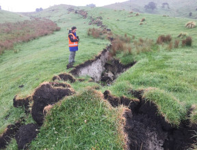
Our ability to assess and interpret landslide deformation patterns and landslide hazard are dependent on accurately understanding the mechanisms that result in damage within a slope. That damage controls the size and frequency of landslides, and how far the landslide may travel once initiated. It has been challenging to assess national landslide hazard and risk as actual scale, location and impact of landslides can be very localised and difficult to forecast. However new remote sensing technology or analytical methods open opportunities to rapidly integrate different sources of data and produce nation-wide landscape maps.
-
Questions our researchers answer
- How do earthquakes and rainfall pre-condition slopes to fail and what are the thresholds for failure?
- How do the geotechnical properties of slopes influence the causes and mechanism of landslide development?
- What are the magnitude and frequency characteristics of landslides in different parts of New Zealand and can these data be incorporated into robust landslide risk models?
- How do hazards cascade in time and space and how can that knowledge be incorporated into awareness, preparedness and planning?
- What factors should be used for the design of safe slopes and how can these be used to develop nation-wide standards and guidelines?
-
The tools we use to answer these questions
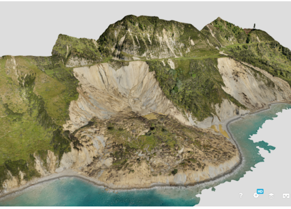
- Surface Mapping: Landscape/terrain classification and identification of landslides and unstable slopes, remote sensing and terrestrial laser scanning
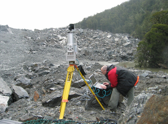
- Land Instability Surveying and Monitoring: Long range Terrestrial Laser Scanner, GNSS, Precise levelling, High definition photography – gigapan, Real-time monitoring
- Numerical Modelling: Stability analyses for slopes, landslides and natural dams using limit equilibrium finite element and runout modelling techniques.
- Hazard and Risk Assessments: Evaluation of landslide types (ranging from debris flows to translational slides), natural dams and constructed slopes, including risk-based approaches
- Community Participation: Hazard management through community risk perception studies, social impact assessments, education, land-use planning and pre-event recovery planning.
GNS Science landslide tools
GNS Science manages the New Zealand Landslide database, which includes the date, location, size and damage of significant landslides, as well as a list of all known landslides.
The GNS Science Geomechanics (Rock and Soil) Laboratory is a facility set up for the determination of the mechanical properties of rock and soil materials. The landslide team uses this facility to determine material strength at failure, deformation under loading, and investigate material performance under different stress conditions. Measured properties are mainly applied to landslide movement mechanisms and the behaviour of rock masses.