
EILD – Earthquake-induced Landscape Dynamics
Over what time scales do landscapes heal after major earthquakes? This programme seeks to answer that question by studying landslides and other sediment hazards caused by the Kaikōura earthquake.
Overview
Along with learning more about time scales, we also seek to develop a framework and tools to allow people to manage the risk to life, property and infrastructure from future earthquake-induced landslides both in Aotearoa New Zealand and internationally.
Earthquake-induced landscape dynamics (EILD) is an MBIE Endeavour programme led by GNS Science in association with experts from leading landslide research institutions in New Zealand and a suite of international experts.
This programme aims to
- quantify landslide activation thresholds and forecast landslide severity at different magnitudes of ground shaking and rain
- determine how far landslide debris volumes travel downslope and model how sediment cascades from hillslope to sea
- evaluate the longevity of dams caused by landslides
- assess the performance of earthworks infrastructure subject to earthquake-induced landsliding
- develop a decision-making framework and set of tools that will inform landslide risk assessment and risk-management methods and practices
To achieve these aims, we will
- use the Kaikōura earthquake as a laboratory to quantify post-earthquake landscape dynamics
- use state-of-the-art geophysical methods, mapping, ground profiling, field monitoring, laboratory testing, and numerical modelling to gather data from this landscape
- integrate this data with existing knowledge to determine how hillslopes and rivers will respond to future forcing events and to better understand landslide risks across New Zealand
The project
Landslides – Immediate and long-term hazards
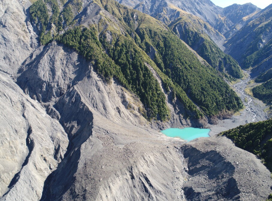
Large earthquakes can generate thousands of landslides. Landslides damage and destabilize hillslopes. They can also create dams across rivers or streams, causing flooding upstream of the dam. Landslide dams and damaged hillslopes are susceptible to failure long after the initial landslide event. Failures can be triggered by rainstorms and aftershocks. When a hillslope fails, debris is mobilized and continues to cascade from hillslope down to sea, creating new landslides, dams or other hazards. When a landslide dam fails, it can cause sudden, intense flooding downstream.
The knock-on effects of an initial landslide may persist for decades, representing a prolonged risk that must be managed by the impacted communities and stakeholders.
Kaikōura Earthquake
On 14 November 2016, the Mw 7.8 Kaikōura earthquake damaged homes, businesses, primary production and infrastructure. Much of this damage was caused by the landslides. GNS Science researchers have identified over 29,000 landslides over a 7,000 km2 area that were a result of the Kaikōura earthquake. About 50 of these initial landslides caused dams, although future hillslope failure may cause additional dams to form.
The Kaikōura earthquake provides a laboratory for studying how the hillslopes and rivers are impacted by earthquakes and for how long. The results from the Kaikōura-centric research will be combined with legacy research to:
- determine landslide risk during and after an earthquake
- better predict the severity of post-earthquake landslides caused by aftershocks and rain events
- determine how long it takes for landscapes to heal after major earthquakes
Earthquake Dam, Linton New Zealand
Our landslide research
Our landslide research falls into six key research areas.
- Landslide severity – We are forecasting landslide severity at different magnitudes of ground shaking and rain. To do this, we investigate the interaction between surface fault rupture and the initiation of landslides, using geophysical field data, monitoring, laboratory testing and numerical modelling.
- Landslide reactivation – We are investigating post-earthquake landslide triggering and reactivation thresholds from ground shaking, rain and time. We will define potential rock and soil failure mechanisms and their thresholds using specialist laboratory tests.
- Landslide dam longevity – We are using physics-based approaches to evaluate how long landslide dams may last in the landscape. We will geotechnically characterise landslide dam materials and simulate potential dam-failure scenarios to quantify their likely longevity and impact.
- Landslide runout – We are determining how far the debris from different types of landslides may travel down a slope. We will use back analysis with physics-based 3D numerical simulations to investigate the controls on landslide runout and to calibrate the empirical relationships.
- Sediment cascades – We are investigating river catchments impacted by landsliding to quantify the supply and transport of sediment through river systems over time and its impact on river dynamics. Numerical models capable of estimating cumulative impacts downstream will be developed.
- Earthworks performance – We are investigating and analysing the performance and behaviour of earthworks infrastructure in the area affected by the Kaikōura Earthquake. The data we generate will be used to develop recommendations for assessment and geotechnical design of future earthworks for enhanced resilience.
Management tools for earthquake-induced landslides
Findings from studying the Kaikōura Earthquake will be combined with past findings to generate the information and tools needed for managing landslide hazards and risk in New Zealand. The new knowledge we generate will help us improve forecasting of landslide hazard severity from different earthquake scenarios as well as landslide dam failure and post-earthquake landslides caused by aftershocks or rain events.
We will be designing predictive tools within a decision-making framework to better inform landslide risk avoidance and residual risk-management methods and practices for people and stakeholders impacted by landslides.
Results from our research, along with the tools and framework we develop will be made accessible via workshops, technical reports, journal articles, code and geodata repositories. We are also committed to effectively engaging stakeholders (such as geotechnical practitioners, designers, planners and policy makers) in the development of useful tools. The knowledge we generate will be applicable in the area affected by the Kaikōura earthquake and in areas affected by future earthquakes, both in New Zealand and overseas.
Landslide Planning Guidance
The Landslide Planning Guidance: Reducing Landslide Risk through Land-Use Planning (the Guidance) developed under the EILD programme sets out how landslide risk can be reduced through consistent land-use planning practices and approaches. Depending on the land use decision-making process, five levels of susceptibility, hazard and risk assessment are recommended from basic qualitative to detailed quantitative risk analysis. The Guidance also walks users through the multiple planning tools available to manage, mitigate and avoid landslide risks to prevent costly and potentially dangerous new developments that could pose a risk to people, property and the environment.
Visit the Guidance web page
-
Publications
Research programme details
Collaborators: University of Canterbury; Victoria University of Wellington; University of Auckland; WSP; Durham University; Disaster Prevention Research Institute, Kyoto University; Simon Fraser University; Université de Rennes 1; DesignSafe-CI
Duration
2018–2023
Funding platform
Endeavour Fund
Status
Current
Leader
Chris Massey
Funder
Ministry of Business, Innovation and Employment (MBIE)
Our partners