
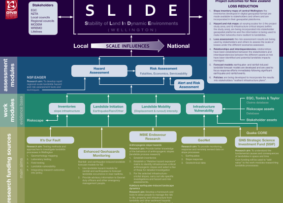
SLIDE - Stability of Land in Dynamic Environments
This project improves resilience of Wellington’s infrastructure through improving knowledge of the behaviour of anthropogenic slopes and developing strategies for more robust remediation approaches.
Overview
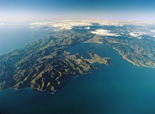
Stability of Land in Dynamic Environments (SLIDE) is a GNS Science research project that investigates the impact of landslides in Aotearoa New Zealand.
This project aims to
- assess the performance of anthropogenic slopes in central Wellington under earthquake shaking, significant rain events, and a combination of both
To achieve these objectives, we will
- provide stakeholders with new knowledge about the response of anthropogenic slopes to earthquakes and changes in groundwater
- deliver best practice hazard and risk assessment methods to assess and quantify slope performance
- recommend robust remediation approaches to infrastructure-critical slopes
The project
Anthropogenic slopes – a landslide hazard
Anthropogenic cut slopes and fill bodies are common throughout Aotearoa New Zealand. Between the early 1900s and 2019, there were more than 1,600 fill bodies and nearly 3,000 cut slopes formed within the central Wellington area alone.
Since the 1950s, larger scale earthworks – at the suburb scale – have been implemented. As a result, much infrastructure including lifelines (such as water, electricity, gas and telecommunications) are now sited on or below anthropogenically modified slopes.
These slopes are particularly susceptible to landslides, whether from earthquakes, rainfall or a combination of the two. The Stability of Land in Dynamic Environments (SLIDE) project, started in 2015, assesses the performance of anthropogenic slopes in central Wellington under earthquake shaking, significant rain events, and a combination of both. Currently, work is focused on landslide forecasting in future rain and earthquake events.
Early outcomes
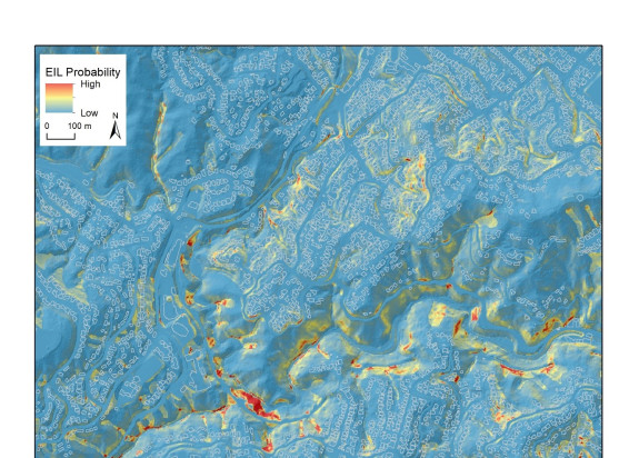
At the beginning of the project, we conducted both regional- and site-specific investigations of landslides in the Wellington region. At the site-specific scale, we carried out ground investigations of select “infrastructure-critical slopes”. These investigations involved compiling historical datasets on past landslides, field mapping and the development of geomorphological maps for the central Wellington region, drilling/trenching, installing monitoring equipment and geophysical surveys.
We combined these regional-scale datasets to, for example, model the probability of a landslide occurring at a given location if subjected to 24-hour rain amounts equivalent to the 100- and 200-year return periods. We also modelled the probability of a landslide occurring at a given location if subjected to for example a 7.8 magnitude earthquake. The distance debris would travel downslope on large slopes was calculated, depending on whether it was a rain or earthquake induced landslide.
Landslide hazards were combined with infrastructure to determine the intersection of landslides and infrastructure in central Wellington. On a site-specific scale, once the properties of the selected slopes were determined, we built numerical models to simulate the response of these “infrastructure-critical slopes” under various loading conditions (e.g. earthquake and non-earthquake triggers).
Key outcomes
The local (Wellington) regional-scale rainfall-induced landslide (RIL) hazard models developed by this programme are being upscaled so they can be applied nationally. The models are currently being incorporated into Geonet’s RIL forecast tool, to forecast landslide occurrence around New Zealand in response to near-real time rain forecasts. The Wellington RIL model will first be trialled across the Wellington region to forecast landslides in near real-time using NIWA rain forecasts.
Hazard models and other information and knowledge generated by SLIDE are currently being used by national and regional organizations.
- Department of Conservation benefitted from the landslide risk assessment guidelines developed by this programme through the commission of a quantitative risk assessment of the Franz Josef and Fox Glacier valley, Westland.
- The New Zealand Geotechnical Society intend to use the fill/cut slope design and risk assessment guidelines in their future geotechnical guidance modules.
- The It’s Our Fault research programme is incorporating scientific data into councils’ preparation for landslide hazard and risk planning and will be largely underpinned by outputs from SLIDE’s earthquake-induced landslide models.
-
Publications
Journal papers
- Debris flow-slide initiation mechanisms in fill slopes, Wellington, New Zealand(external link)
- Geomechanical characterisation and dynamic numerical modelling of two anthropogenic fill slopes(external link)
- Geomechanical characterisation of discontinuous greywacke from the Wellington region based on laboratory testing(external link)
- The utility of earth science information in post-earthquake land-use decision-making(external link)
Failure mechanisms of Wellington fill slopes during earthquakes and rainstorms; J. Carey
Literature review on the geotechnical properties of the Wellington region greywacke; M-A. Brideau
Wellington rock slope characterisation and response to earthquakes; C.I. Massey
Wellington regional scale landslide hazard models; C.I. Massey
Cosgrove, B. 2018. Mechanisms of rainfall-induced landsliding in Wellington fill slopes. Victoria University of Wellington MSc thesis.
Cosgrove, B.; Carey, J.M.; Norton, K. 2017 Mechanisms of rainfall-induced landsliding in Wellington fill-slopes. p. 23 IN: Baker, J.; Rowe, M. (eds) Geoscience Society of New Zealand Annual Conference 2017 : dynamic New Zealand, dynamic earth : University of Auckland, November 28 - December 1 : abstract volume. Wellington, N.Z.: Geoscience Society of New Zealand. Geoscience Society of New Zealand miscellaneous publication 147A.
Massey, C.I.; Lukovic, B. 2018 A prototype earthquake-induced landslide forecast tool for New Zealand. p. 109-111 In: The abstract book of MEGE 2018 : the 5th International Symposium on Mega Earthquakes Induced Geo-disasters and Long Term Effects. Chengdu, China: State Key Laboratory of Geohazard Prevention and Geoenvironment Protection.
GNS Science Reports
SR2018/27 – SLIDE (Wellington): Vulnerability of dwellings to landslides; C.I. Massey
SR2019/28 – SLIDE (Wellington): Geomorphological characterization of the Wellington urban area; D. Townsend
SR2019/36 – SLIDE (Wellington): Development of an infrastructure model for analysing the potential impact of landslide in the Wellington Urban Area; D. Heron
SR2019/37 – SLIDE (Wellington): Rainfall induced and earthquake induced landslide hazard models; C.I. Massey
SR2019/38 – SLIDE (Wellington): Empirical and physics-based landslide runout models; S. deVilder
SR2019/39 – SLIDE (Wellington): Review of Geomechanical Data for Greywacke in the Wellington Region; M-A. Brideau
SR2019/40 – SLIDE (Wellington): Geotechnical laboratory testing of Wellington Greywacke cores in unconfined compression; B. Lyndsell
SR2019/41 – SLIDE (Wellington): Summary of borehole image and full-waveform acoustic processing and interpretation results; M. Lawrence
SR2019/42 – SLIDE (Wellington): Methodology for quantitative landslide risk assessment; S. deVilder
SR2019/43 – SLIDE (Wellington): Selection of representative ground motion input for the Wellington region; L. Abbott
SR2019/44 – SLIDE (Wellington): Priscilla Crescent Site Specific Hazard and Risk Assessment; M-A. Brideau
SR2019/45 – SLIDE (Wellington): Orchy Crescent Site Specific Hazard and Risk Assessment; M-A. Brideau
SR2019/46 – SLIDE (Wellington): Dungarvan Road Site Specific Hazard and Risk Assessment; M-A. Brideau
SR2019/47 – SLIDE (Wellington): Bendigo Grove Site Specific Hazard and Risk Assessment; C.I. Massey
SR2019/48 – SLIDE (Wellington): Ngauranga Gorge Site Specific Hazard and Risk Assessment; C.I. Massey
SR2019/49 – SLIDE (Wellington): St. Gerard Monastery Site Specific Hazard and Risk Assessment; C.I. Massey
SR2019/50 – SLIDE (Wellington): A summary of the data, methods and assessments; C.I. Massey
SR2019/51 – SLIDE (Wellington): Literature review of slope design guidance across NZ and internationally; F. Monteith
SR2019/52 – SLIDE (Wellington): Risk remediation approaches for anthropogenically modified slope in Wellington region; F. Monteith
Research project details
Collaborators: The Natural Hazards Commission Toka Tū Ake, Wellington Water, New Zealand Lifelines Committee, Wellington City Council, New Zealand Transport Agency, MCDEM and regional CDEM groups, It’s Our Fault Programme
Duration
2015–present
Funding platform
Hazards and Infrastructure - Targeted Research
Status
Current
Programme leader
Chris Massey
Funder
MBIE