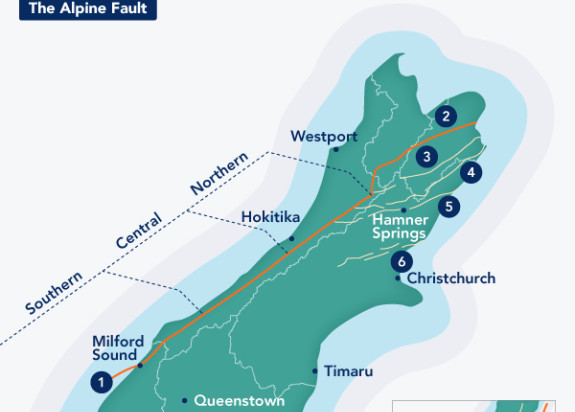
Alpine Fault

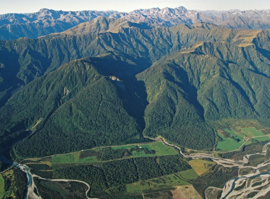
Running up 600km on the spine of Aotearoa's South Island, the Alpine Fault is one of the world’s major geological features.
The Alpine Fault is the visible "on-land" boundary of the colliding Pacific and Australian Plates.
The Alpine Fault is one of the largest sources of seismic, or earthquake, hazards in Aotearoa New Zealand. Historically, when this fault ruptures, it produces an earthquake of about magnitude 8.0.
Movement of the Alpine Fault
Horizontal movement of the Alpine Fault is about 30m per 1000 years, which is considered very fast by global standards. Each time it has ruptured, it has also moved vertically, lifting the Southern Alps in the process. In the last 12 million years the Southern Alps have been uplifted by an amazing 20 kilometres, and it is only the fast pace of erosion that has kept their highest point below 4000 metres. The glaciers and rivers have removed the rest of the material and spread it out across the lowland plains or onto the sea floor. The rapid uplift also means that faulted rock from deep down has been brought to the surface, and can be studied by scientists.

History of ruptures
The fault has ruptured four times in the past 900 years, each time producing an earthquake of about magnitude 8. Approximate rupture dates are 1717AD, 1620 AD, 1450 AD, and 1100 AD. Knowledge gained by our research into drilling deep into the fault extended our knowledge of the Alpine fault's earthquake record back through the past 8000 years.
Drilling into New Zealand's Most Dangerous Fault – GNS Scientists drilled more than 1km down into the Alpine Fault. transcript
The Alpine Fault is the largest source of seismic hazard (earthquake hazard) in the South Island.
We think that the Alpine Fault fails in magnitude 8 earthquake approximately every 330 years.
The last event occurred, we think, in 1717 AD around 300 years ago, so we are pretty sure that the Alpine Fault is at the end of what we would call it seismic cycle.
It's due to have another earthquake. We have a detailed record of Alpine Fault earthquakes during the last 8000 years.
if you do the statistics on the recorded Alpine Fault earthquakes, the probability of an Alpine Fault earthquake occurring in the next 50 years is about 28 percent.
That is a very high probability by global standards.
Earthquakes happen when movement occurs on geological fault, and scientists are trying to understand how that rupture occurs.
Scientific drilling projects have investigated faults which recently ruptured in earthquakes.
In California near Parkfield, in Fenghuang in China, after the Kobe earthquake in Japan and after the Chi-Chi earthquake in Taiwan for example. Tthey have provided us with some fantastic insights into the state of the geological fault recently ruptured.
The international science community has this question: What does a fault look like before an earthquake ?
That's where our project comes in.
The Alpine Fault is probably the best example worldwide of a fault that we know that could fail in a magnitude 8 earthquake, and hasn't in the last 300 years.
The Alpine Fault runs the entire length of the South Island and it runs all the way up through Nelson lakes and and emerges with a
complex set of faults in Marlborough.
On one side the fault are some big mountains -the Southern Alps because one side of the fault is being pushed up, and on the other side we've got the coastal plain of Westland.
If we were to go and look deep into the earth we would see that the Alpine Fault is not a vertical fault.
It's quite steeply dipping in some places but in the Central Alps dips at about 45 degrees. We can trace that fault in the central South Island to about 30 kilometers in depth.
So we can trace it through the brittle part of the crust the uppermost 8-10 kilometers where earthquakes happen, and into the ductile regime where we can see it's geophysical signature, but it's only real signs of life are small amounts of tremor that we can record on seismometers.
There are a range of different things that we need to know.
We need to know what will happen in an Alpine Fault earthquake. And that's going inform us, that's gonna help us to plan.
It's gonna help us to build the right buildings, and it's going to help us to build infrastructure. At least predict what will happen to infrastructure like roads, bridges, etc.
Also, we would like to know if the probability of an Alpine Fault rupture varies from day to day, and at the moment we don't know, but it's possible that we will be able to make forecasts in the future.
And finally, if an Alpine Fault earthquake happens, it's such a large event it may go for hundreds of kilometers.
We may actually be able to make warning system and give people a few tens of seconds, maybe a minute of warning which would be potentially very very useful if you were, say, driving a fast vehicle or controlling a power station.
So we aim to drill to about just over one kilometers depth and collect samples from the fault.
The materials will help us to understand what the fault is made of. It will go off to laboratories to be analyzed.
We will also put instruments down the borehole to make observations in place, geophysical observations to measure it's physical properties in place, and to measure the ambient conditions within the crust.
Then finally we will install equipment within the borehole -an observatory, a fault zone Observatory that will monitor natural phenomena that going on and help us to understand the types of phenomena that go on around that fault, and may in the future one day, be the basis for forecasting or warning system.
The Alpine Fault has a high probability of rupturing in the next 50 years.
The rupture will produce one of the biggest earthquakes since European settlement of New Zealand, and it will have a major impact on the lives of many people. In between earthquakes, the Alpine Fault is locked. All these things mean that the Alpine Fault is a globally significant geological structure.