Experts look at impacts of rainfall on ground damaged by Cyclone Gabrielle
As the North Island reels from the effects of Cyclone Gabrielle, more rain is forecast. We take a look at the impacts continued rainfall might have on damaged ground.
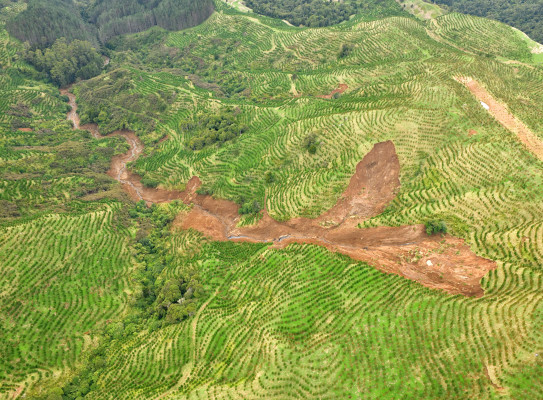
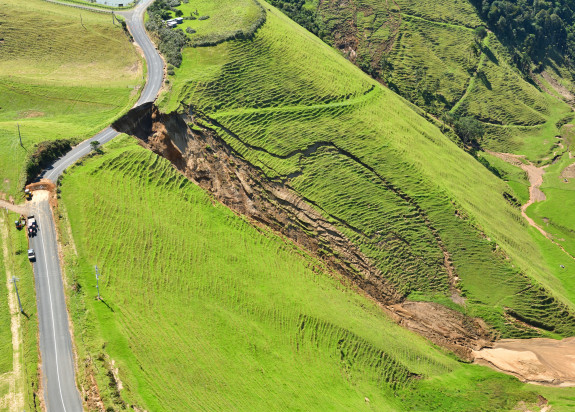
As a result of the cyclone, tens of thousands of landslides occurred across the North Island. As the ground affected by these landslides is now weakened with cracks, loose debris, and plenty of water, many will continue to move slowly and can cause ongoing damage to the land and structures built around them. In some cases, additional rainfall or shaking from an earthquake may be enough to ‘re-activate’ landslides and debris fields, generating hazardous rockfalls and debris flows that could impact people or property.
GNS Science experts expect ongoing instability over the next weeks as the ground dries out and creeping landslides slow down.
“Floodwaters saturate the ground which reduces the cohesion of the soils, adds volume and introduces vulnerability,” GNS Geologist, Kerry Leith, explains.
Damaged ground leaves hillsides weaker and more susceptible to rainfall or earthquakes in the future. They can fail at any time, sometimes without any apparent trigger or warning.
“We often see heightened creep rates from both soil and rock instabilities that can last for several weeks. Landslides occur when the accumulated strain within a slope finally exceeds the strain limit of the material, and we can’t always predict when that might happen.”
The best advice the experts have is to stay away from areas of damaged ground, and treat every landslide with extreme caution.
With so many thousands of landslides evident throughout much of the North Island it is going to take many weeks to assess the risk they might pose.
GNS landslide teams have been flying over the most heavily impacted regions doing helicopter surveys – looking for hidden hazards like landslide dams up in the hills and failing slopes throughout Auckland and Northland, Coromandel, Gisborne, Hawke’s Bay and south as far as Masterton. They are particularly looking for landslides that might move further and cause life safety risk or damage critical infrastructure.

Landslide activity and risk assessment information is used to help local authorities manage their community safety plans. The precautionary evacuation effected yesterday for 64 homes in the Mangahauini River catchment and Tokomaru Bay township highlights science’s role in informing the response. The forecast rainfall was thought to pose an increased landslide risk in this area and a conservative approach was immediately applied by local authorities to ensure public safety.
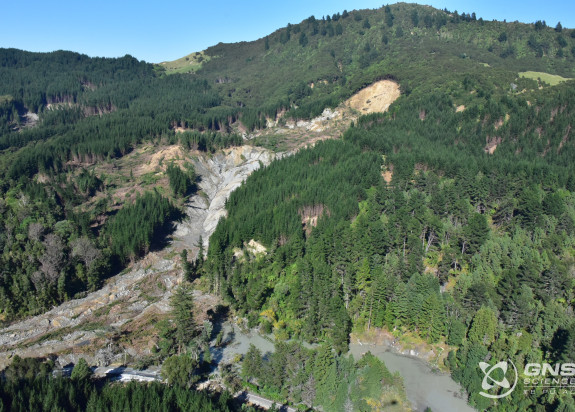
There was concern that an unstable dam of debris from an old landslide that had reactivated during Cyclone Gabrielle might not be able to sustain increased saturation from the expected rainfall. Further movement of the existing material or additional localised sliding could have significant impact. If the landslide dam failed catastrophically, the township could be flooded.
Protecting public safety in the Mangahauini River catchment and Tokomaru Bay was considered a necessary caution until an expert science assessment could be completed. In the meantime, the Tairāwhiti CDEM and the Police managed the evacuation.
Sally Dellow, GNS Science Response Controller, says that the National Emergency Management Agency (NEMA) has brought GNS Science landslide experts in to work with the Gisborne District Council.

The more evidence-based information our GNS Science team can provide the emergency management teams and national decision makers, the better equipped the national response is to keep communities safe.
“Anyone concerned about landslide activity in any region should stay well away and contact their local council.”
-
More information for those in impacted areas
- Damaged ground weakens hillsides and makes it more susceptible to rainfall or earthquakes
- Landslide debris on slopes can further slip and, depending where it is located, can pose a life safety risk or threaten infrastructure
- Homes near hills or steep slopes are most at risk
- People should stay away from any cliffs, particularly coastal and around waterways in the regions that have been badly affected by the cyclone
- Report any concerns to your local council