

Sliding Lands Hōretireti Whenua: Landslide Hazards pillar
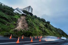
The Landslide Hazards pillar aims to develop a National Rapid Landslide Hazard Model (NRLHM) for Aotearoa New Zealand that can generate hazard footprints for fast-moving landslides triggered by both earthquakes and rainfall. The model will capture both typical and worst-case scenarios, providing a nationally consistent picture of where rapid landslides are most likely to occur and where they may travel.
By linking these hazard footprints with information on people, buildings, infrastructure, and other assets, the programme will help identify high-risk hotspots and support the development of a national hazard-exposure-risk framework.
To achieve this, the Landslide Hazards pillar will develop probabilistic landslide susceptibility models that forecast where rapid landslides are likely to be initiated under earthquake and rainfall triggering conditions. These models will combine physics-based understanding with machine learning approaches, and will be calibrated to Aotearoa’s diverse physiography, geology, and climate.
The research will also advance susceptibility modelling by including harmonised datasets, investigating multi-scale approaches that go beyond simple pixel-based methods, and improved treatment of temporal pathway dependencies. In parallel, a validated suite of landslide runout models will be developed for different landslide types, enabling the programme to estimate how far landslide debris may travel, and what may be impacted downslope.
Aim
To provide a nationally consistent understanding of landslide hazards and support better planning, preparedness, and response across New Zealand.
How?
The research combines information from past landslide events, geology, terrain, climate, and advanced modelling techniques to:
- Identify where landslides are most likely to occur.
- Understand how local conditions influence landslide activity.
- Estimate how far landslides may travel.
- Identify areas, people, and assets that could be affected.
- More detailed studies will be undertaken in selected hotspot areas to refine the model and improve understanding of uncertainty and risk.
The National Rapid Landslide Hazard Model (NRLHM) will provide an evidence base that can support a range of decisions, including:
- Emergency preparedness and response.
- Recovery planning following major storms or earthquakes.
- Land-use planning and development.
- Infrastructure planning and asset management.
- Risk reduction and resilience initiatives.
The model is intended to act as a national screening tool, helping identify areas where landslide hazards may need further investigation.
Key outputs
- National Rapid Landslide Hazard Model (NRLHM).
- National landslide source hazard models
- National landslide runout models.
- Forecast and post-event landslide hazard maps.
Students
The Hazards Pillar supports several PhD students who are helping advance landslide science and modelling.
- Rainer Hayer (Durham University) – Furthering landslide susceptibility analysis by investigating multiscale approaches that go beyond the pixel.
- Marius Scheider (ETH Zurich) – Applying a GPU accelerate runout model to understand and forecast the runout of earthquake and rainfall induced landslides at a regional scale.