Deep Fault Drilling ProgrammeDrilling into a live earthquake fault

Alpine Fault

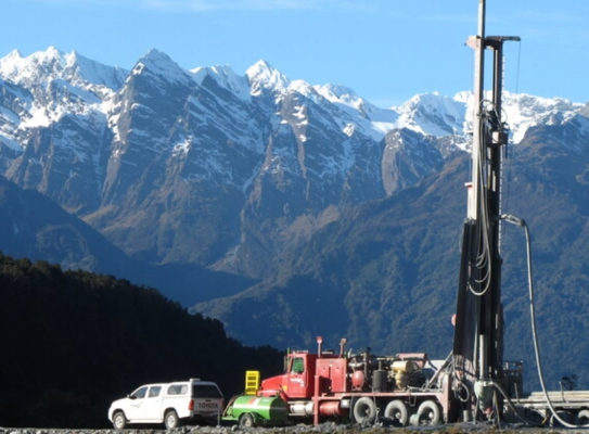
The Deep Fault Drilling Programme drilled nearly 1km into the fault to understand more about its behaviour.

Overview

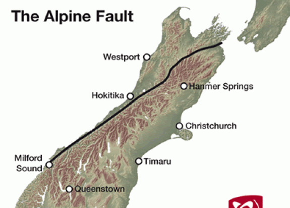
The Alpine Fault runs for about 600km up the spine of the South Island. It’s the land boundary between the Pacific and Australian Plates, and one of the world’s major geological features.

Five things to know about the Alpine Fault.

  1. It has ruptured four times in 1,000 years – 1717, 1620, 1450 and 1100 – producing an earthquake of about M (magnitude) 8 each time.
  2. The likelihood of a major rupture in the next 50 years is much higher than we thought(external link).
  3. The fault is moving horizontally by about 30m per 1,000 years — very fast by global standards. It’s also moving vertically – the alps have been uplifted by an amazing 20km in the last 12 million years. It’s only the fast pace of erosion that has kept their highest point below 4,000 metres.
  4. The rapid uplift has brought deep faulted rock to the surface, enabling scientific study. That same uplift restricts earthquake activity to depths shallower than normal.
  5. Drilling into a live fault overdue for a rupture gives us a rare opportunity to see the state of the fault before it breaks.

Fractured and strongly-layered rocks and extremely hot temperatures put an end to the drilling. While DFDP at Whataroa didn’t achieve all of its technical goals, it made some unexpected discoveries.

The project

A large Alpine Fault rupture could affect us for 50 years

Research from GNS Science and the University of Otago suggests a large Alpine Fault earthquake will trigger a cascade of environmental effects that could last for up to 50 years:

  • violent shaking along the entire length of the rupture will trigger large landslides in steep land and weaken hillslopes making them more susceptible to landslides in subsequent storms
  • as West Coast rivers and streams transport material from these landslides downstream, rivers will change their courses abruptly and more frequently
  • this cascade of impacts may affect towns, road, communications and power infrastructure for decades after the earthquake
  • aftershocks reach M7 and continue for many years

What is the Alpine Fault?

The Alpine Fault in the South Island forms part of the boundary between the Australian and Pacific Plates.

It lies near the base of the steep western range-front of the Southern Alps, stretching over about 600km between Milford Sound and Marlborough. It is visible from space as a more-or-less straight line delineating the western side of the Southern Alps. South-west of Milford Sound, it extends southwest-wards offshore from Fiordland for about 200km. North of Hanmer Springs, it branches into several faults including the Hope Fault and the Wairau Valley Fault.

The Alpine Fault
The Alpine Fault

When the fault slips, land goes sideways and up.

  • the Southern Alps are lifted up
  • rocks are offset laterally by hundreds of kilometres. For example, the Red Hills in Nelson and Red Mountain in South Westland were once joined but have been offset from one another
  • during the last two million years, the central portion of the fault has slipped at an average rate of about 27mm/year horizontally and 10 mm/year vertically

Scientists believe this sort of slip happens mostly during earthquakes of M7.5–8 every 200–400 years. Each time, one side of the fault moves horizontally by approximately 7–9m and 0–3m vertically with respect to the other side of the fault.

Why is the Alpine Fault so interesting?

In the simplest of terms, it’s the way it moves.

When the fault slips, it displaces the rocks on either side horizontally and vertically: rocks on the eastern side of the fault move southwest-wards and upwards. Over time, rocks that were deeply buried beneath the Southern Alps are brought to the surface.

This happens so rapidly – in geological terms – that the rocks don’t have time to cool and many temperature-controlled processes that normally occur at great depth persist to much shallower depths. By studying these processes and the mineralogical and structural signatures they leave behind, we can learn about how the Alpine Fault behaves at the depths at which earthquakes nucleate (approximately 6–12 km). Using rock and fluid samples collected from boreholes enables us to see through the effects of near-surface weathering and erosion.

The Alpine Fault dips downward into the earth at an angle of about 45°. This means we can penetrate the fault more cheaply and more easily than with vertical faults such as the San Andreas Fault(external link).

Drilling into the Alpine Fault – Why would you want to drill into an active plate boundary? transcript

New Zealand sits on a boundary between two tectonic plates, and there's a very large fault, the Alpine Fault, which ruptures right through the South Island of New Zealand and accommodates most of that plate motion.

The way that geologists have studied the fault is by going into the field and looking at the exposures of the fault in natural outcrops.

And they've built up a picture, they've pieced a collage together of how they think the fault zone structure is. Now what we're going to do, is to take a drill rig and we're going to drill a continuous set of rock cores through the fault and make a set of geophysical observations down that borehole.

So for the first time, we'll actually get all of the observations in one place going right through the fault zone. The first objective is to collect a continuous set of rock cores which will go off and be studied by all sorts of different techniques and people.

The second objective is to put a suite of very sophisticated geophysical instruments down the borehole, and make a set of observations, scans if you like, of the borehole wall.

The third objective is to install some very sophisticated equipment including very sensitive seismometers into the borehole so that we can create a fault zone observatory which will become a long-term monitoring station.

At this stage, there is nobody that can honestly predict earthquakes, and so in terms of how you live your life, you just have to go on with your life knowing that one day, a magnitude 8 earthquake will probably occur on the Alpine Fault.

However, it's only really in the last decade that these fault zone observatories, and these very sensitive geophysical observatories have been installed, and we've already found all sorts of phenomena that we never knew about 10 years ago.

So when we install this observatory, the honest answer is that we don't know what we're going to find.

Drilling into the Alpine Fault

Why would you want to drill into an active plate boundary?

Minerals and the Alpine Fault – Virginia Toy explains how scientists know when they are drilling near to New Zealand's Alpine Fault. transcript

The drilling project that we're undertaking is a three-phase process and the rig that we have is the one that we use for the second phase of the drilling experiment it's a typical drill rig that's used in the minerals exploration industry.

It's drilling into what's known as the basement rock which is this same hard rock that you see on all the hills around the place here.

At present, the drill rig is using a drill bit known as a polycrystalline diamond bit. It has teeth on it and it chews it's way through the rock, creating chips known as 'cuttings'.

So the bit is down there in the ground chewing up the rock, and up above it we have a whole lot of circulating fluids, and the chips of rock get caught up in the fluid and they're brought to the surface and you can see this outflow of mud that appears, and in it are all these little chips of rock.

Our geologists will go to the rig, they take the 'cuttings' and wash them. Then we take that material and we split it up.

We separate out the quartz chips which are white, and we have a representative sample that has no quartz chips. Those two samples are passed on to that the thin section preparation team.

A thin section is a sliver of rock that has a thickness of 30 microns - that is a 30,000th of a millimeter. It is so thin that if you pass light through it you can see through it.

It's a method that geologists typically use to identify different minerals that make up the structure of a rock. In our case it's really important that we have those thin sections so that we can work out which part of the rock sequence we are in.

There are some really diagnostic minerals and some really diagnostic shapes to the minerals that are going to tell us where we are.

we expect the rock to change character little bit as we approach the Alpine Fault, that's because the alpine fault is sheering this rocket at depth and it breaks up the minerals, it makes them into finer grain sizes and it changes the way they're arranged. Based on what we can observe in terms of the grain size and the arrangement of the minerals it tells us as geologists how close we are to the principal slip surface of the alpine fault.

There is a point at which we can tell we are about 300 meters above the principal slip surface of the Alpine Fault and when we hit that point, we switch to coring which is the third phase of the drilling process.

We all hope that someday we'll be able to predict earthquakes, but it is not something realistic that geologists can offer New Zealanders, or the rest to the world.

It is realistic that we can help people to understand what ground shaking is likely from the next earthquake, what's the hazard scenario that I have to be prepared for personally, what is likely to happen at my house or at my workplace.
If you know what is likely then you can be prepared for that.

The kind of research we're doing here is really important because the processes that happen like fracturing of the rock change the kind of earthquake that is going to be generated.

What we are doing in this project in particular is helping to understand what our realistic earthquake scenarios are.
It's really important for New Zealanders to understand what's possible so they can be prepared, and our whole society - our emergency management, the people that legislate how houses are built, we can do that kind of design, that kind of planning as appropriately as possible.

Minerals and the Alpine Fault

Virginia Toy explains how scientists know when they are drilling near to New Zealand's Alpine Fault.

The Deep Fault Drilling Project (DFDP)

Experts believe the Alpine Fault is ready to fail in a large earthquake within coming decades.

Deep Fault Drilling (DFDP) gives us a rare opportunity to determine the state of the fault in the late phase of its seismic cycle – before it breaks. Most other projects have to drilled into active faults after major earthquakes(external link).

DFDP-1: This first phase was completed in February 2011 with two boreholes intersecting the Alpine Fault at Gaunt Creek, South Westland.

DFDP-2 began in October 2014, targeting the Alpine Fault c1km below the Whataroa River Valley.

These two projects were led by GNS Science, Victoria University of Wellington and the University of Otago. Altogether, they involved nearly 100 scientists from more than a dozen countries. They retrieved rock and fluid samples, took geophysical and hydraulic measurements, and set up a long-term monitoring observatory inside the fault zone.

Drilling into New Zealand's Most Dangerous Fault – In 2014 Scientists being drilling more than a kilometre down into the plate boundary fault in New Zealand's South Island. transcript

The Alpine Fault is the largest source of seismic hazard (earthquake hazard) in the South Island.
We think that the Alpine Fault fails in magnitude 8 earthquake approximately every 330 years.
The last event occurred, we think, in 1717 AD around 300 years ago, so we are pretty sure that the Alpine Fault is at the end of what we would call it seismic cycle.
It's due to have another earthquake.
We have a detailed record of Alpine Fault earthquakes during the last 8000 years.
if you do the statistics on the recorded Alpine Fault earthquakes, the probability of an Alpine Fault earthquake occurring in the next 50 years is about 28 percent.
That is a very high probability by global standards.
earthquakes happen when movement occurs on geological fault, and scientists are trying to understand how that rupture occurs.
scientific drilling projects have investigated faults which recently ruptured in earthquakes.
In California near Parkfield, in Fenghuang in China, after the Kobe earthquake in Japan and after the Chi-Chi earthquake in Taiwan for example. they have provided us with some fantastic insights into the state of the geological fault recently ruptured.
The international science community has this question: What does a fault look like before an earthquake ?
that's where our project comes in.
The Alpine Fault is probably the best example worldwide of a fault that we know that could fail in a magnitude 8 earthquake, and hasn't in the last 300 years.
The Alpine Fault runs the entire length of the South Island and it runs all the way up through nelson lakes and emerges with a complex set of faults in Marlborough.
On one side the fault are some big mountains -the Southern Alps because one side of the fault is being pushed up,
and on the other side we've got the coastal plain of Westland.
If we were to go and look deep into the earth we would see that the Alpine Fault is not a vertical fault.
It's quite steeply dipping in some places but in the Central Alps dips at about 45 degrees.
We can trace that fault in the central South Island to about 30 kilometers in depth.
So we can trace it through the brittle part of the crust – the uppermost 8-10 kilometers where earthquakes happen, and into the ductile regime where we can see it's geophysical signature, but it's only real signs of life are small amounts of tremor that we can record on seismometers.
There are a range of different things that we need to know.
We need to know what will happen in an Alpine Fault earthquake.
And that's gonna inform us, that's gonna help us to plan.
It's gonna help us to build the right buildings, and it's going to help us to build infrastructure.
At least predict what will happen to infrastructure like roads, bridges, etc.
Also, we would like to know if the probability of an Alpine Fault rupture varies from day to day, and at the moment we don't know, but it's possible that we will be able to make forecasts in the future.
And finally, if an Alpine Fault earthquake happens, it's such a large event it may go for hundreds of kilometers.
We may actually be able to make awarning system and give people a few tens of seconds, maybe a minute of warning which would be potentially very very useful if you were, say, driving a fast vehicle or controlling a power station.
So we aim to drill to about just over one kilometers depth and collect samples from the fault.
The materials will help us to understand what the fault is made of
It will go off to laboratories to be analyzed.
We will also put instruments down the borehole to make observations in place, geophysical observations to measure it's physical properties in place, and to measure the ambient conditions within the crust.
Then finally we will install equipment within the borehole -an observatory, a fault zone Observatory that will monitor natural phenomena that going on and help us to understand the types of phenomena that go on around that fault, and may in the future one day, be the basis for forecasting or warning system.

Drilling into New Zealand's Most Dangerous Fault

In 2014 Scientists are drilling more than a kilometre down into the plate boundary fault in New Zealand's South Island.

Is it ok to drill into the Alpine Fault? – Will drilling through a plate boundary fault risk causing a damaging earthquake? transcript

The Alpine Fault is a big fault and for this reason it's of interest to earthquake scientists all over the world.

We've been working with the principal investigators of the project to assess the safety of the drilling plan.

Is this something that can be accomplished without posing an undue risk to people and to property?

Part of our review has been to go through in great detail the plans that they have for drilling the hole not only to make sure that it is safe from a logistical standpoint, but also to make sure that there really is no possibility that this project will generate a damaging earthquake.

This really is a very safe project for a number of reasons. One is that the depth at which the fault will be encountered is really quite modest.

1200 meters sounds like a long distance underground but it's really far above the zone where earthquakes begin.

That would be the concern, someday we may want to penetrate a big fault at greater depth, but this experiment is really very safe from that standpoint.

Earthquakes at shallow depth or extremely rare anywhere in the world and on the alpine fault we know from studies that have been conducted recently that they're typically three kilometers or deeper, so that risk is very small.

Another reason that the risk is a small is that the perturbations that would be made to the system by drilling are really very modest.

It's a small hole, so the region that will be affected is very very minimal. In addition they have a very good monitoring system in place that will allow them to notice any changes in activity that are anomalous, and they would react immediately to those.

So those of us who reviewed the safety plan feel very confident that they are on the right track.

Is it ok to drill into the Alpine Fault?

Will drilling through a plate boundary fault risk causing a damaging earthquake?

Will the Alpine Fault produce another Darfield?

The Darfield quake on 4 September 2020 was a M7.1 (M = magnitude).

If the Alpine Fault produced a M8.1 quake, it would release about 30 times more energy than Darfield. Here’s the science: for every one unit increase in magnitude – say, from M4 to M5 – there is about a 30-fold increase in energy release.

A rupture in the Alpine Fault will likely:

  • happen over several hundreds of kilometres rather than several tens of kilometres
  • last hundreds of seconds rather than tens of second
  • affect a much larger area than the Darfield earthquake
  • produce an aftershock sequence of earthquakes with at least two M7

Remember: the size of an earthquake is not the only factor determining its severity. We saw this with the 2010–2012 Canterbury earthquake sequence: the M6.3 Christchurch earthquake had a much greater effect than the M7.1 Darfield event five months earlier.

Upton Phaedra 2317

Phaedra Upton Land and Marine Geoscience Theme Leader

Phaedra is a geodynamic modeller who researches a wide range of problems in tectonics. She is adept at using numerical models in collaboration with geologists from a range of subdisciplines to produce insights into a large variety of processes including faulting, fluid flow, heat transfer, drainage evolution, placer gold deposition and the relationship between tectonics and genetics. As a Theme Leader at GNS Science, she practises authentic and collaborative leadership. She promotes diversity of thought and inclusivity as vital to achieving our scientific goals. Phaedra was the 2020 New Zealand Geosciences Hochstetter Lecturer.

View Bio Contact Me

Find more content related to:

GNS Science topics

By continuing with this download you agree to abide by the rules laid out in the Terms and conditions/Terms of use listed on this page.

If there are no specific Terms and conditions/Terms of use listed then please refer to our Copyright and Disclaimer page and Privacy Policy page

Download