Volcano monitoring
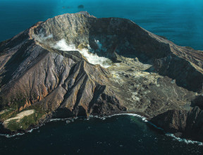
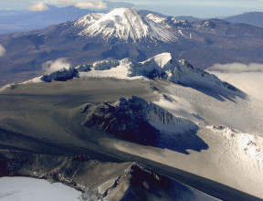
Volcanoes are iconic features in Aotearoa New Zealand’s landscapes. Several of these volcanoes are active or have the potential to become active in the future. They pose very real threats to lives, livelihoods, infrastructure and the landscape.
Studying volcanoes provides valuable insight into the timing, size and extent of past eruptions, which provides very useful information for predicting and modelling future eruptions.
Monitoring our volcanoes
Understanding the risks and hazards associated with our volcanoes is of paramount importance, and GNS Science maintains an interdisciplinary team that forms the volcano monitoring group to monitor our volcanoes. This group keeps a close eye on the current state of our volcanoes. Changes in the status allows responding agencies to assess the hazardscape.
There are eight active volcanic areas in New Zealand with several active and potentially active volcanoes located in these areas. Although the probability of an eruption affecting a large area is relatively low in any given year, New Zealand needs to be prepared for a range of volcanic eruptions.
Volcano Monitoring in Aotearoa New Zealand transcript
New Zealand has 12 active volcanoes that
we monitor as part of the GeoNet programme.
Our plate tectonic setting creates these
volcanoes, which are unique
features of the landscape,
and they attract
thousands of visitors per year.
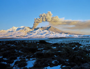
Volcanoes are awe-inspiring, but they're
hazardous in an eruption.
Monitoring volcanoes allows us to
understand how active a volcano is,
and what the likelihood is that it could
erupt in the near future.
We inform our key stakeholders so they
can make decisions
based on that information,
and maybe actions that
they might need to take.
Volcanic activity is driven by magma.
As this magma rises to shallow levels,
gases and fluids from it
interact with the
volcano's hydrothermal system.
This can create seismic, chemical,
thermal, and visual
indicators of activity,
as well as ground deformation.
These indicators give us insights into
what may be happening in a volcano.
We use several techniques to collect data
to monitor volcanic activity,
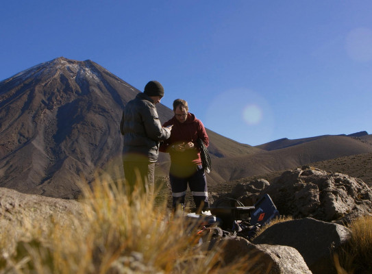
and oftentimes we use remote
monitoring stations like this.
There's a range of equipment that our
field stations may have.
We use seismometers for ground shaking.
We monitor ground deformation.
We have acoustic sensors
to detect a volcanic blast,
spectrometers for volcanic gases,
and we have data loggers recording
temperatures and levels of volcanic features,
such as crater lakes,
fumaroles, and hot springs.
We also have a network of cameras that
provide visual confirmation
of any activity occurring on the surface.
Some data, like volcanic gas samples,
need to be collected
manually at a volcano.
This can be done either by gas
measurement flights,
or directly sampling
fumaroles or crater lakes.
These gas samples are
analysed in our labs,
and importantly they tell us if fresh
magma is moving in the volcano
and interacting with
the hydrothermal system.
Many of our monitoring sites are in harsh
volcanic environments.
Because of this, the
sites need to be robust enough
to continuously operate
for long periods of time.
Near active volcanic vents, however,
solar panels can lose their effectiveness
from the shadowing
effect from a denser plume,
from ash in the air, and from ballistics
damaging the solar panels.
Keeping instrumentation and other
electronics operational
in volcanic environments
has its challenges.
The areas can be highly corrosive,
so we take steps to seal the electronics
away from the air as best as possible,
and use materials that can better
withstand the harsh environment.
Our remote infrastructure
monitoring team maintain the sites
in order to keep the data flowing,
so it can be available for the National
Geohazards Monitoring Centre,
our duty officers, and scientists.
Our monitoring data helps us set the
volcanic alert level
for each of the volcanoes.
We collect all of that information to
tell us about the state
of unrest of the volcano,
or if it's an eruption, how
that eruption is progressing.
All of this data collectively allows us
to understand the state of the volcano,
and the information that we provide from
that comes through in the
volcanic activity bulletin.
This is our way of communicating the
status of the volcano at any given time.
Every little piece of
data we collect and interpret
helps us to understand
more about how volcanoes work.
In addition to monitoring volcanoes for
their scientific benefit,
the information that we provide plays a
key role in keeping people safe.
-
The Volcano Monitoring Group
Monitoring the active volcanoes in New Zealand is undertaken by the Volcano Monitoring Group using the skills and experience of GNS Science researchers, the GeoNet geophysical networks and the NGMC response capability. The monitoring group aims to maintain an up-to-date understanding of the current status of activity or volcanic unrest at New Zealand’s volcanoes. The group also aims to make this information available to stakeholders and researchers to inform research into volcanoes and to inform disaster management and evacuation plans.
To achieve these aims, the group conducts a variety of monitoring activities, including remote monitoring and on-site monitoring, for all of our active volcanoes. We maintain a 24/7 response capability, communicate the current status of a volcano by setting the Volcanic Alert Level (VAL) for each volcano and inform the responding agencies, stakeholders, infrastructure operators and the public of this status in Volcano Activity Bulletins (VABs).
-
Studying the past
Studying both extinct and active volcanoes gives us insight into our volcanic past, present and future. To look into the wonders of our volcanic environment, our researchers:
- Use radioactive isotopes to date the eruptions
- Link rocks to past eruptions to see how far material travelled
- Conduct geochemical analyses of material expelled to understand the state of the magma system driving the volcano when it erupted
- Examine the material from a particular site for clues to the duration, magnitude and length of each phase of an eruption
-
Studying the present
We also monitor the present conditions of New Zealand’s active volcanoes. Monitoring efforts for these volcanoes include:
- Visual observation
- Chemical analysis
- Seismic and acoustic monitoring
- Ground deformation
Data from monitoring of our volcanoes is fed into GeoNet. The Volcano Monitoring team gauges the present state of our active volcanoes and communicates this through the New Zealand Volcanic Alert Level system and through direct communication with stakeholders, responding agencies, infrastructure providers and the public.
-
Mātauranga Maori
Māori oral history records may provide insight into eruptions of the recent past and changes noted in the pre-eruption landscape. We work with Māori practitioners to provide a more holistic understanding of the behaviour of our maunga. Mātauranga Māori also informs the development of useful, culturally-relevant disaster management and recovery plans that ensure mana whenua are supported through recovery and in developing resilience.