Zealandia just became the first continent to be completely mappedA world first in undersea mapping
It's true, we've just completed mapping Zealandia.
The latest study revealed several new discoveries too - including the stretch of Zealandia's ancient backbone, and a giant volcanic region the size of New Zealand.
Six years ago, Zealandia was announced as Earth's eighth continent.
In 2017, a groundbreaking study led by GNS Scientists outlined evidence of Te Riu-a-Māui / Zealandia's continental characteristics - from its thick and geologically varied crust, to its size and isolation from Australia.
Just before this 2017 announcement, an international team set sail on an expedition near New Caledonia to obtain seabed rock samples of North Zealandia.
Now in 2023, our scientists have confirmed these seabed samples have just unlocked three major new discoveries about the continent.

Continent mapping completed - a world first
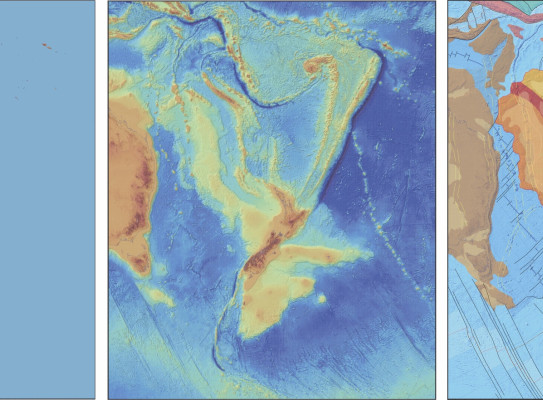
All of Earth’s continents include submarine shelves that are mostly hidden underwater, making them rather difficult to map and explore. As such, the geology of most continental shelves is poorly known, leaving geological maps with large grey areas across the Earth's surface.
Zealandia's discovery has faced the same challenges, but its continental shelves are even wider and more hidden than most - with only about 5% of the continent peeking above water.
Now, as the last continent to be discovered, this latest study establishes Zealandia is the first ever continent to have its geology, volcanoes and sedimentary basins fully mapped out to its underwater edges.
The latest study builds on the work of a 2019 publication by GNS scientists and colleagues in the journal Tectonics which mapped the geology of 1.5Msq km South Zealandia. The findings revealed the extent of stretching, twisting and thinning of the continental crust as it separated from Gondwana.
The latest 2023 Tectonics publication, shifted focus from South Zealandia to the North, mapping the geology of the underwater region between New Zealand, New Caledonia and Australia.
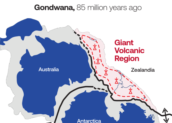
Giant volcanic region a ‘smoking gun’ for Gondwana supercontinent breakup
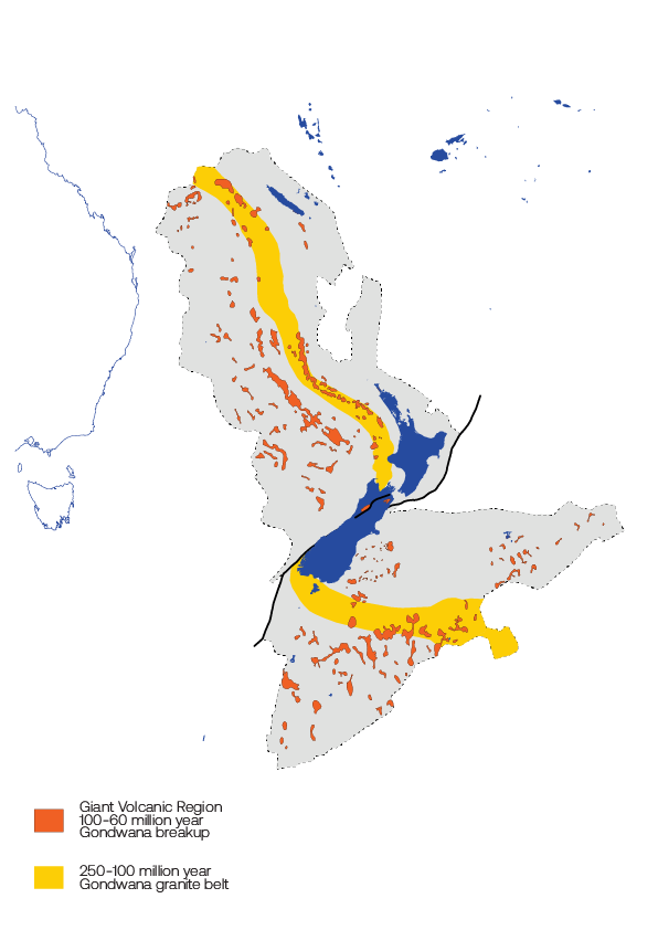
Another key finding of the 2023 paper is the discovery of a giant volcanic region, which ignited along the edge of the Gondwana supercontinent between 100 and 60 million years ago.
Lead author, GNS Scientist Nick Mortimer says "For the first time we realise the extent of the magma eruptions of different ages imprinted across different parts of Zealandia."
Co-author, GNS Scientist Wanda Stratford says, "Until now, the role of magma in Gondwana breakup has been underestimated. We can now see these lavas cover an area of 250,000 km2 across the continent - about the size of New Zealand itself."
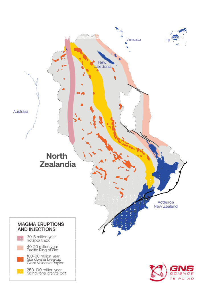
Hidden mostly underwater, the volcanic areas were revealed by their strong magnetic signature which was identified by the study's magnetic surveys of sea floor. The magnetic anomalies in these areas co-inside with those same basalt lava rocks that had been surfaced by rock dredges.
The same magnetic lava rocks are found onland too near Cape Reinga, Blenheim, Hokitika and Ashburton, as well as in New Caledonia, the Chatham Islands and Auckland Islands.
The giant volcanic region and its remnant magnetic lava rocks are a result of Zealandia's separation from Gondwana between 100 and 60 million years ago.
Watch: Zealandia separate from Gondwana
The 100-million-year evolution of our continent
For this period of at least 40 million years, molten magma flooded out of cracks and fissures as the continent stretched and thinned like pizza dough.
Zealandia's ancient granite backbone
The seabed rock samples collected from Fairway Ridge near New Caledonia also included some granites, another type of magmatic rock, that belong to a 4000 km transcontinental belt. With these samples, the 2023 study joined the final dots between the continent's underwater and onland granites through dating and chemical analysis.
This granite backbone of Zealandia is called the Median Batholith by geologists. Now, this discovery allows us to fully map the curving stretch of 250 - 100-million-year-old granite backbone.
While the continent is the first to be completely mapped out to its submarine edges, much exploration and discovery remains. Not just what is where, but when, how and why the major geological events that have shaped our continent took place.
The big scale continent-wide framework that we now have for Zealandia provides a useful context for ongoing, more focussed research into New Zealand’s natural hazards, resources and environment. The ECOSAT II 2016 R/V Investigator expedition which collected the seabed samples used in this study was funded by the Australian government and co-led by geoscientists from the University of Sydney. The writeup of the recent paper was funded by a New Zealand Government Grant to GNS Science’s Te Riu-a-Maui / Zealandia Research programme and by a Te Aparangi – Royal Society James Cook Fellowship to Nick Mortimer.
-
Is Te Riu-a-Māui / Zealandia really the world’s 8th Continent?
On 10 February 2017, the Geological Society of America journal GSA Today published a peer-reviewed, open access science article online called Zealandia: Earth's Hidden Continent. Read it here(external link)(external link)
The authors were nine GNS Science staff plus two colleagues from the Geological Survey of New Caledonia and the University of Sydney. The paper had taken many months to write and its origins went back many years to a mix of onshore and offshore GNS Science research projects.
The evidence presented in this paper described 4.9 million square kilometres of the South West Pacific Ocean as underlain by a submerged continent, Zealandia. The paper also showed that Zealandia - like other continents - is large, relatively high, has thick crust, and contains rocks like granite and greywacke. Its continental crust thickness was measured as between 10km and 30km, and increasing to more than 40km under parts of the South Island.
In a 2019 study, GNS scientists and colleagues published a scientific paper in the journal Tectonics on the geology of 1.5 Msq km South Zealandia. This work tracked granites and lavas across the Campbell Plateau to the Chathams and Subantarctic islands and revealed the thinning twisting and stretching of continent as its pulled away from Gondwana nearly 100 million years ago.
The supercontinent separation was reconstructed in a series of maps published in a GNS Science-led 2022 paper(external link). We animated the maps and you can see the 100-million-year evolution of our continent in a video here(external link).
In 2021, GNS Scientist Rose Turnbull, lead authored a paper in Geology(external link)(external link). Her findings revealing that the continent of Te Riu-a-Māui / Zealandia is older than previously thought and we could trace its geological whakapapa back to the ancient supercontinent Rodinia that existed more than 1 billion years ago.
Unfortunately, there is no formal body to approve a continent. As other scientists use Zealandia and cite this research then this validates our work, and the name Zealandia will become more commonly accepted. But it will take time. We hope that Zealandia will eventually make its way onto general world maps, be taught in schools and become as familiar a name as Antarctica.
Read more here(external link)(external link).
-
Why is the continent called Te Riu-a-Māui / Zealandia?
The name Zealandia was first proposed by geophysicist Bruce Luyendyk in 1995 as a collective name for New Zealand, the Chatham Rise, Campbell Plateau, and Lord Howe Rise.
In 2018, GNS Science asked respected Auckland University academic, Associate Professor Mānuka Hēnare, to research and recommend a Māori name that reflected the nature and position of the continent.
Professor Hēnare has 12 years' experience as Associate Dean of Māori and Pacific Development, so he can draw from both perspectives. He was instrumental in naming three ships for the Royal New Zealand Navy (Te Kaha, Te Maru and Te Mana) and is well practised at recommending names that are acceptable across the Pacific.
Te Riu-a-Māui literally means the hills, valleys and plains of Māui - the great East Polynesian ancestor explorer of the Pacific Ocean.
Riu means hull (of a canoe), basin (like the Waikato basin), a belly, the core (of a body). It is the whole that holds the parts together.
Māui is an ancestor of all Polynesians. He sailed and explored the great ocean and caught the fish which he and his crew pulled up. The fish became many of the islands we know today.
The name Te Riu-a-Māui brings together traditional oral narratives and geological science.
-
Our research at GNS Science
Knowledge of our continent has enduring value. Mātauranga, embodied in part through our databases, samples and collections, informs geological processes that shape Te Riu-a-Māui as well as enriches Māori and Pasifika narratives of exploration and discovery.
We hold more than 150 years of knowledge about Te Riu-a-MāuiWe are proud and dutiful custodians of eight Nationally Significant Collections and Databases that hold foundational knowledge about our continent. Our data supports essential research for building resilience in our communities to natural hazards, unlocking energy and critical mineral resources and developing critical climate change and environmental insights.
Te Riu-a-Māui Zealandia SSIF Programme
GNS Science also leads a geoscience research programme that is investigating and exploring the Earth system structure, evolution, past climate and processes of the 8th continent, Te Riu-a-Māui Zealandia, for the benefit of New Zealanders.
Find more content related to:
GNS Science areas
- Earth Dynamics
- Coastal Change
- Our Natural Resources
- Our Past
- Landscapes and Seascapes
- Te Riu-a-Māui Our Continent