
Vertical land movement key to understanding future sea-level rise
In May, the NZ SeaRise: Te Tai Pari O Aotearoa programme released the first ever location specific sea-level rise projections for New Zealand. The projections incorporate vertical land movement data – a game-changer in our understanding of rising sea levels.
GNS Science InSAR Scientist Ian Hamling played a key role in producing the vertical land movement estimates that sit at the heart of these new projections.
How has NZ SeaRise estimated vertical land movement?
“With around 15,000 kilometres of coastline, we knew traditional approaches to measuring vertical land movement were impossible. To overcome this, we combined observations from interferometric Synthetic Aperture Radar (InSAR) and GPS stations to increase the breadth and density of vertical land movement estimates”.
Using radar images captured by satellites, InSAR measures the change in distance between the land surface and the satellite. By differencing radar images acquired at different times, we can generate deformation maps – called interferograms – covering large areas but at high resolutions.
The team used SAR images between 2003 and 2011 for their estimates. This minimised the influence of large earthquakes that have struck New Zealand since 2011 and altered regular patterns of uplift and subsidence.
“Using all of the available images, we generated more than 2500 individual interferograms to estimate the vertical displacement rate over an eight-year period. We then used GPS data to check these InSAR observations and put them in a consistent reference frame” says Ian.
The result is the highest resolution and most systematic map of countrywide vertical land movement that has ever been produced. We now have bespoke sea-level rise projections for every two-kilometre stretch of our coastline.

With around 15,000 kilometres of coastline, we knew traditional approaches to measuring vertical land movement were impossible.
GNS Science Environment and Climate Theme Leader Richard Levy is one of the co-leaders of SeaRise. He says that the new projections will provide invaluable insight for decisionmakers as they plan to adapt to a changing climate.
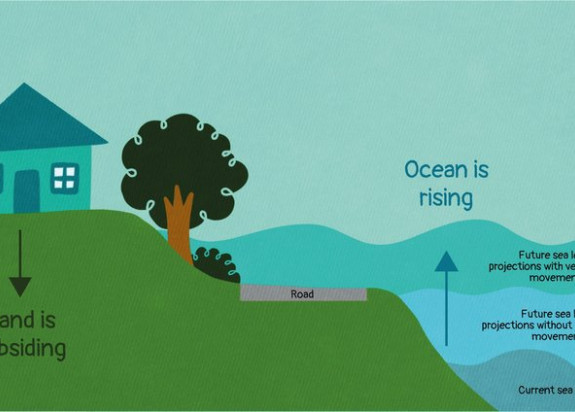
“Understanding the impact of vertical land movement on sea level rise significantly changes the time we have to plan for its impacts. The amount of sea level rise we might expect to occur in 50 to 60 years could actually happen in two or three decades.
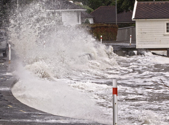
“In Wellington, the amount of sea-level rise that local infrastructure can handle is relatively small at 30 centimetres. That amount of sea level rise is already unavoidable, no matter how much we curb emissions. This will drastically change the frequency of inundation events – turning once in a century flooding into an annual event.
“At the same time, land in much of Wellington is sinking at nearly the same rate that global sea levels are rising. So, we can expect that 30 centimetres to happen twice as quickly, and planners need to be fast-forwarding adaptation plans.”

The SeaRise projections are available to explore through an online interactive map. The new projections are being incorporated into the next Ministry for the Environment guidance for local government practitioners on coastal hazards and climate change.
NZ SeaRise is a five-year research programme funded by the Ministry for Business, Innovation and Employment Endeavour Fund. It brings together 30 local and international experts from GNS Science, Te Herenga Waka-Victoria University of Wellington, NIWA, University of Otago and the Antarctic Science Platform to improve projections of sea-level rise in Aotearoa New Zealand. The sea-level projection and mapping tool was developed by Takiwā, a Māori-owned data management and analytics platform.