GNS welcomes upgrade of hazard monitoring network
The proposed upgrade of New Zealand’s geological hazard monitoring network will lead to greatly improved monitoring of geological hazards and strengthen disaster management response, Chairman of the Institute of Geological & Nuclear Sciences Limited (GNS) Derek Milne said today.
Dr Milne paid tribute to Toka Tū Ake EQC for taking a first substantial step toward providing New Zealand with an upgraded and fit-for-purpose hazard monitoring network. EQC will contribute $5 million a year for at least 10 years toward the upgraded network, called GeoNet.
New Zealand is located dangerously on the boundary of the Australian and Pacific tectonic plates that are grinding past and overriding each other. The several decades of relative calm New Zealand has experienced conceals the fact that we face significant geological hazards, and the improved network will help to lower the risks we live with.
"It is crucial for New Zealand’s long-term economic security to improve the understanding of the geological hazards we face, and to use this knowledge to help reduce economic and social damage resulting from a major earthquake, volcanic eruption, landslide, or tsunami," Dr Milne said.
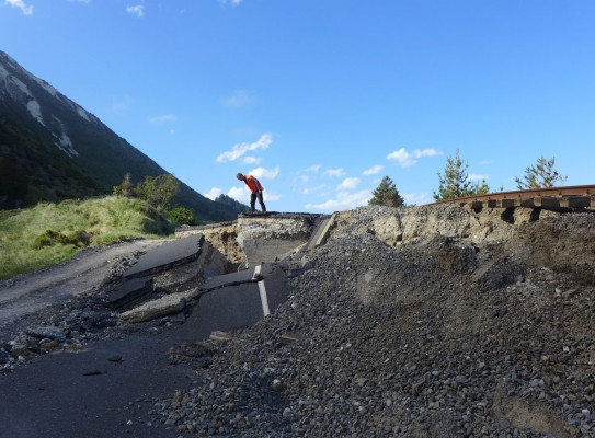
He said the existing network was old, sparse, and parts of it were regularly failing. There was a partial upgrade in the 1980s, but these instruments were now obsolete. GeoNet will take advantage of new technology and be fully integrated with equipment to be used to monitor the Comprehensive Nuclear Test Ban Treaty.
GeoNet, which will be phased in steadily over several years, represents a huge step forward in making New Zealand more resilient to the impact of earthquakes, volcanic eruptions, landslides, and tsunamis.
"We hope that electricity, water, communications, and transport companies, and local and regional councils will take advantage of, and invest to supplement, the broad range of real-time geological hazard information that this truly modern network will provide."
Dr Milne summarised the main benefits of GeoNet as:
- Earthquake Emergency Response: When fully operational, it will provide accurate details within minutes on the size and location of an earthquake, and the severity of ground-shaking in different locations. This information is crucial to organisations charged with mobilising help or planning an emergency response, and for rapidly evaluating the likelihood of damage to buildings and other key structures.
- Public information: A moderate to large earthquake causes alarm and immediately raises the questions, " Where? What size? How bad? Will there be more?" The upgrade will allow GNS to provide more detailed information more quickly in the wake of an earthquake or eruption.
- Warning of volcanic eruptions: When fully in place, it will give scientists an improved ability to detect early signs of volcanic unrest and impending eruptions. This will allow valuable time to organise effective community and business response.
- Warning of tsunamis: The first warning that an offshore earthquake may have generated a tsunami comes from seismic monitoring. Tsunami detection and warning requires regional co-operation and appropriate technology. The upgrade will enable New Zealand to make a valuable contribution in the South Pacific.
- Seismic hazard assessment: The upgrade will enable GNS to develop better intelligence on the severity of ground-shaking that can be expected in various parts of New Zealand. This information is relevant to decisions about where to site roads, bridges, water, oil, and gas pipelines and buildings that are better able to withstand ground-shaking.
- Earthquake engineering: Recordings of earthquake shaking in buildings, bridges, roads, airports, oil and gas pipelines, dams and other structures are an essential ingredient in safe, cost-effective design and construction. The upgrade will provide improved knowledge of how structures perform during earthquakes. This will enable engineers to improve design and construction techniques.
- Scientific research: The upgrade will enable scientists to pursue new avenues of research that, internationally, are leading to a better knowledge of geological hazards. It will also greatly strengthen existing research.
- Insurance and mitigation: Improved data from GeoNet, plus scientific research, will contribute substantially to the knowledge of geological hazard and risk throughout New Zealand. This knowledge is used to assess potential losses from future hazard events and to adjust the risk, and hence the cost of insurance cover. Greater knowledge will also lead to smarter decisions about siting and design of buildings, engineering lifelines, and structures.
GEONET – AN UPGRADED HAZARD MONITORING NETWORK
Question and Answer
(Finance Minister Dr Michael Cullen has announced the beginning of a multi-million dollar upgrade of New Zealand’s geological hazard monitoring network. The Earthquake Commission is to contribute $5 million-a-year toward the upgrade and operation of this network. The Institute of Geological & Nuclear Sciences Limited (GNS) will install and operate the new equipment.)
Answers to questions 8 & 9 should be attributed to David Middleton, General Manager of the Earthquake Commission. All other answers can be attributed to Dr Robin Falconer, Hazards Group Manager, Institute of Geological & Nuclear Sciences Limited (GNS).
1. What is the "geological hazard monitoring network"?
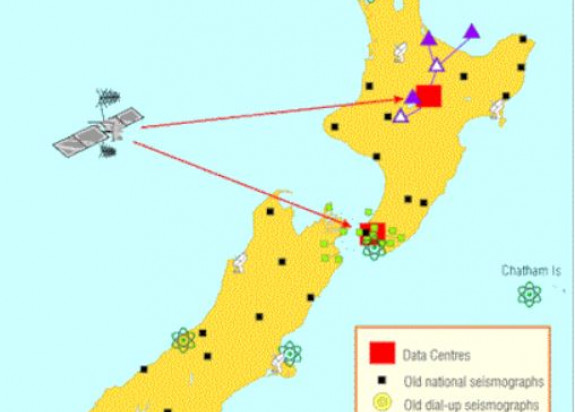
Seismographs and other instruments for measuring earth movements over varying time intervals at several hundred sites around New Zealand - a bit like weather stations. The network was mostly installed by the former Department of Scientific and Industrial Research and is now operated by the Institute of Geological & Nuclear Sciences Limited (GNS). A few sites have been upgraded in recent years with new digital recording equipment linked by satellite or telephone to GNS data centres in Wellington and Wairakei. Data from these upgraded sites are available in near real time.
The remaining instruments are several decades old and most lack communication links. This means that the data from the existing network are of poor quality for modern research purposes and in general the data are not available for analysis until several weeks after they were recorded. So, during an emergency such as a large earthquake or the build up to a volcanic eruption, scientists, territorial authorities, and civil defence staff would have little appreciation of what is happening. In five to seven years, when the rollout of new equipment is complete, scientists and emergency managers will be able to access information from throughout New Zealand at the click of a mouse.
2. What is wrong with the existing equipment?
Much of the equipment currently in use in New Zealand is several decades old and is increasingly difficult to maintain. Equipment failures are increasingly common. The existing instruments are unable to provide rapid and reliable hazard information that would be needed during an emergency. The information presently available from the network is inadequate for scientists to pursue new avenues of research that, internationally, are leading to a better knowledge and understanding of geological hazards.
3. What equipment is being bought?
Seismographs to accurately measure the magnitude and location of earthquakes; Global positioning system (GPS) equipment to pin-point earth deformation so that scientists can see where strain is building up in the earth's crust; Seismic, chemical, and GPS equipment to provide early detection of volcanic unrest in the North Island; Seismic recorders for buildings, bridges and other structures to provide engineers with information on how those structures perform in an earthquake. This will lead to improved design and safer structures. Much of the equipment in the network will be linked by satellite and radio to data centres in Wairakei and Wellington. Currently only small parts of the network are linked by radio and satellite.
4. Where is the equipment coming from?
Where possible, it is being sourced from New Zealand. Components are also being imported from the United States and Britain.
5. How will this equipment compare to monitoring systems used by other developed countries?
GeoNet will initially be modest by international standards, but consistent with "best practice" in its design. The EQC commitment represents an extremely important first step towards a major improvement on our existing networks.
6. Will the equipment enable scientists to predict earthquakes and volcanic eruptions?
It will give scientists an improved ability to detect early signs of volcanic unrest or an approaching eruption at some volcanoes. Short-term earthquake prediction is not currently possible, but scientists will be able to use the new equipment to see where strain has accumulated or has been released within the earth’s crust. The initial investment will provide a backbone network that eventually will lead to comprehensive coverage of New Zealand’s high hazard regions. When fully implemented, GeoNet will greatly increase the ability of scientists to detect and interpret the changes that precede earthquakes and volcanic eruptions. It will also allow them to reliably predict damage levels within minutes of a big earthquake. This information will be extremely valuable, especially for those involved in emergency response.
7. Will the upgraded network help save lives?
Yes. When fully operational, it will provide more precise, more comprehensive and more rapid information on geological hazards. The improved intelligence will enhance the ability to respond quickly and effectively to a crisis. As well as helping to save lives and reducing suffering, it will help communities to recover more quickly after a damaging event by providing more information more rapidly than is possible at present. Improved volcano surveillance is designed to give a longer lead time before eruptions. This will enable improved civil defence decision-making ahead of a volcanic crisis.
8. Why is the Earthquake Commission funding this project?
Funding this upgrade is consistent with EQC’s statutory role "to facilitate research into matters relevant to natural disaster damage".
9. Will the outlay affect the Earthquake Commission’s ability to meet disaster insurance claims?
No. EQC’s ability to indemnify insured property owners will remain unchanged.
10. Is GNS confident the new network will perform in New Zealand conditions?
Yes. During the past three years GNS has trialled most of this equipment in a pilot project. It has performed well and has matched expectations. The upgrade will be a gradual scaling up of this pilot project.
11. How would the existing network of instruments perform if a big earthquake struck today?
GNS is not able to guarantee the accuracy or robustness of its existing equipment because of its age and because coverage of New Zealand is not comprehensive. The upgrade will make a significant difference.
12. How long will it take for the fully upgraded network of instruments to be in place?
The EQC commitment will allow for a gradual deployment of new equipment over the next five to seven years. If GNS can attract additional funding from other sources, it will enable a faster and more comprehensive rollout. However, improvements in the network’s overall performance will occur within three years.
13. Will the new instruments be spread evenly throughout the country, or are particular areas being targeted?
National coverage will improve gradually as new instruments are deployed throughout New Zealand. Some areas, such as Wellington and the central North Island, will have a higher concentration of instruments.
14. What are the possible consequences of not upgrading this hazard monitoring equipment?
Inability to obtain accurate information on the size and location of a large earthquake for some hours after it occurs. Inability to detect early signs of volcanic unrest. Inability to sustain New Zealand’s earth science and geological hazard research capabilities. An unimproved network represents an unnecessary and undesirable exposure to loss of life and property from the geological hazards associated with living on a highly active plate boundary.