Gabrielle’s intense rainfall made landslides inevitable
Cyclone Gabrielle was one of the most extreme landslide-triggering events ever recorded globally.
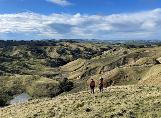
It is estimated that more than 800,000 landslides were caused by the extreme weather event, cumulatively covering an area of around 100 square kilometres – about the same size as the city of Napier.
A thorough analysis of the Cyclone Gabrielle landslides led by Earth Sciences New Zealand, reveals that the ground was so saturated by the amount of rainfall, it didn’t matter how wet ground conditions were beforehand – landslides were going to happen.
Study lead author, Earth Sciences New Zealand engineering geologist Chris Massey (formerly GNS Science), explains that a major factor influencing landslide triggering is how much moisture is already in the soil compared to the amount it can absorb before reaching a critical point and failing.
“In the case of Cyclone Gabrielle, the intense rainfall over a short period overwhelmed the natural drainage systems, and many of the affected slopes were inevitably pushed past their tipping point regardless of the pre-existing soil moisture conditions,” Dr Massey says.

Dr Trevor Carey-Smith, climate scientist at Earth Sciences New Zealand (formerly NIWA), was a co-author on the study, contributing rainfall data and analysis.
“The quantity of rainfall in many locations was unprecedented; inland from Esk Valley 500 mm fell in 24 hours – over 50% higher than the previous record. Rainfall is typically one of the more important factors influencing likelihood of landslides, so the huge quantity of water that fell over a short period of time meant we weren’t surprised that landslides occurred during the event – however the sheer number triggered was astonishing,” Dr Carey-Smith says.
“We already know from attribution studies that climate change contributed to the intensity of rainfall during Cyclone Gabrielle and that this is likely to increase further in future.”
The study, published in Landslides Journal(external link), found that, aside from rainfall, the most significant factors influencing landslide locations were geology type, vegetation type and, of course, the steepness of the slope. Dr Massey says areas covered in scrub and grassland were much more prone to landslides than those with forest.
“In regions like Tairāwhiti-Gisborne and Hawke’s Bay the density of small and shallow landslides occurring in areas with scrub and grassland was extremely high – up to 327 landslides per square kilometre. Such landslide densities are typically much higher than those associated with rainstorms overseas,” Dr Massey says.
“Interestingly, indigenous forests offered better protection than exotic forests.”
Dr Massey notes that places where vegetation had been lost in recent years (3-5 years preceding Cyclone Gabrielle) were more likely to experience landslides.
This finding demonstrates a clear link between deforestation and increased landslide triggering. We hope this research can support informed decisions about land use in the future to help mitigate these disruptive events.
“And with climate change increasing the frequency and intensity of cyclones, there has never been a more pressing time to use science to adapt to our changing conditions and support people, industry and government to be more resilient.”
The data and findings from Cyclone Gabrielle research will support the development of national-scale landslide models to forecast areas where rapid and dangerous landslides may occur and what their impacts could be.
Contributing author, Te Whare Wānanga o Waitaha | University of Canterbury Senior Lecturer in Disaster Risk and Resilience Dr Tom Robinson, led a group of students who mapped most of the landslide data over a nine-month period for the study.
"As far as we are aware, this is the largest number of landslides ever mapped for a single storm, certainly in New Zealand, and provides a valuable source of information for future landslide modelling,” Dr Robinson says.
“This research has given UC students a unique opportunity to be part of core research that will better inform our understanding of landslides during major storms and how the community can adapt to our changing climate conditions."