
Aotearoa New Zealand’s earthquake resilience boosted by release of new hazard model
The National Seismic Hazard Model estimates the likelihood of future earthquake shaking hazard to have increased throughout most of the country, ranging from almost no change to more than doubling in some areas.
On average, results have increased by 50 percent or more from previous modelling, highlighting the need to boost national resilience strategies and readiness.
Led by a team from GNS Science, more than 50 local and international scientists have been collaborating for more than two years on the revision of the National Seismic Hazard Model(external link), which was made publicly available this week.
An important part of New Zealand’s hazard-scape toolkit, the National Seismic Hazard Model (NSHM) provides an estimate of the likelihood and strength of earthquake ground shaking at any given site in New Zealand, and considers how different parts of the country might behave in the event of large magnitude earthquakes.
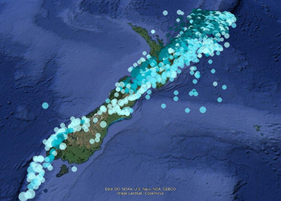
Explaining the National Seismic Hazard Model 2022
Aotearoa New Zealand sits aside tectonic plates and that puts the country at risk of earthquakes....
Funded by MBIE and Toka Tū Ake EQC, the NSHM project incorporates the latest international science and considers the data and knowledge resulting from New Zealand’s significant earthquakes of the last two decades, such as the Canterbury earthquake sequence and the Kaikōura earthquakes
Dr Matt Gerstenberger, GNS Science NSHM Project Lead says it is critical to have an up-to-date understanding of the seismic hazards facing New Zealand to help us manage the risks from earthquakes to people, property and the environment.
The increase in hazard estimates in the 2022 revision is not unexpected. We know a lot more about earthquake behaviour now due to better global understanding, more sophisticated science, and more than a decade of advancements in technical computing.
"Knowing more means we have the ability to make better estimates, allowing various industries who use the model to assess what the hazard results might mean for different locations, and then act to mitigate risks,” Dr Gerstenberger said.
Earthquake hazard varies throughout the country based on the geography and ground conditions in each location, and the frequency and types of earthquakes which might occur.

While the NSHM indicates a general increase in forecast ground shaking hazard across the country, it does not describe its impact, or assess associated risk. Instead, the model is a science instrument which can be used by government and industry to estimate risk and help make risk-based decisions.
When we look at the hazard results for a particular area, it’s important to stress that increased hazard doesn’t necessarily mean a larger impact.
“The impact of ground shaking does not necessarily increase equally to the hazard, because the impact on society includes many additional factors that are not part of the science model - like building aspects and structure design – and the National Seismic Hazard Model doesn’t address those,” Dr Gertenberger explains.
“When interpreting how the hazard results have changed from previous models, we need to consider the relative value of the shaking forecast. For example, if there has been a doubling in hazard in a region with a previously very low estimated hazard, then the updated hazard – though greater – may still be low.
“Northland is a good example of this, where the ground shaking hazard is now estimated at twice its previous known level, but it can still be considered a very low hazard risk region.”
Time will be required to determine how the revised hazard information will factor into policy and practice. The engineering, building and insurance industries will all now be analysing the NSHM data and carefully considering how it might be applied.
Throughout the revision project, technical advice on the development of the NSHM has been provided by a 17-member panel of international scientists and engineers using a participatory review process. An additional 5-member international panel then undertook an assurance review of the science process.
The panel determined that the project team has done an outstanding job in incorporating the best available science, engaging the highest-level relevant expertise among numerous organisations worldwide, and navigating the project around pandemic-related constraints.
The NSHM is freely available HERE(external link) with video and fact sheets provided to help explain the detailed science and regional summaries to outline the key information for different locations.