In the Ocean
New Zealand involvement in scientific drilling in the ocean is through participation in the International Ocean Discovery Program in partnership with Australia (ANZIC).
The International Ocean Discovery Program (IODP)
The International Ocean Discovery Program (IODP) is an international marine research collaboration that explores Earth's history and dynamics using ocean-going research platforms to recover data recorded in seafloor sediments and rocks and to monitor subseafloor environments.
Introducing the International Ocean Discovery Program
IODP is international, multidisciplinary collaboration among scientists, students, engineers, marine technicians and educators
IODP depends on facilities funded by three platform providers (US, Japan and a European Consortium) with financial contributions from additional partner agencies, including ANZIC. Together, these entities represent 21 nations whose scientists are selected to staff IODP research expeditions conducted throughout the world's oceans.
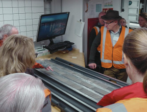
How Science Works
OceanLeadership explored the process of how real science works - using an example from an IODP expedition
Our new projects
-
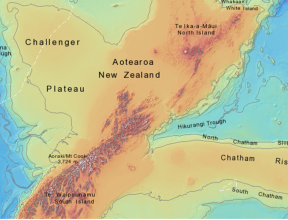
Unlocking the secrets of slow slip by drilling at the northern Hikurangi subduction margin, New Zealand: Riser drilling to intersect the plate interface
Proposal 781B-Full - Over the last decade, the discovery of episodic slow slip events (SSEs) at subduction margins around the globe has led to an explosion of new theories about fault rheology and slip behaviour along subduction megathrusts. The northern Hikurangi margin is the only place on Earth where well-documented SSEs occur on a subduction interface within range of scientific drilling capabilities. Drilling, down-hole measurements, and sampling of the northern Hikurangi SSE source area provides a unique opportunity to definitively test hypotheses for the physical conditions and rock properties leading to SSE occurrence, and ultimately, to unlock the secrets of slow slip.
The project builds on the knowledge gained during two earlier IODP expeditions to the Hikurangi margin (372 and 375) and aims to drill a single riser borehole intersecting the plate interface to collect samples, geophysical logs and make downhole measurements at the source of SSEs. The riser borehole is designed to test a suite of hypotheses about the fundamental mechanics and behaviour of slow slip events, and their relationship to great subduction earthquakes.
-
Probing the physical controls on a locked vs. creeping megathrust with ocean drilling, Hikurangi Subduction Margin, New Zealand
Pre-Proposal 959 - Undersea earthquakes and associated tsunamis have caused some of our planet’s deadliest and costliest natural disasters over the past 20 years. A Mw 7.8 2016 Kaikōura-type upper crust earthquake beneath Wellington is estimated to incur losses to our GDP of ~NZD$30 billion while a larger magnitude subduction zone event is likely to result in loss of life, significant casualties, and widespread devastation.
By directly accessing, sampling, and monitoring the Hikurangi subduction zone offshore Wellington, scientific ocean drilling will enable more reliable forecasts and assessments of the risks to vulnerable coastal populations and infrastructure posed by megathrust earthquakes and tsunamis and will facilitate improved hazard preparedness and response within the Wellington region.
Proponents of Pre-Proposal 959 have been successful in being awarded EUROFLEETS+ ship time on the R/V Tangaroa in 2022 and will use this voyage to complete site survey data acquisition.
-
From arc splitting to oceanic spreading: testing models of back-arc basin
Pre-Proposal 993 - Back-arc basins are found at convergent margins and constitute an integral part of the subduction factory, exhibiting volcanic and hydrothermal processes similar to those found at mid-ocean ridges. Despite their importance in the tectonic history of our planet, very little is known about the mechanisms of formation and early evolution of back-arc basins. Understanding the episodic variations and instabilities of back-arc spreading centres, and their link to subduction processes and arc volcanoes, has become of global importance for the international science community.
Scientific drilling in the Havre Trough is the key to resolving competing hypotheses constraining the genesis and evolution of back-arc basins. The Havre Trough is one of the few places on Earth where the early stages of back-arc basin formation are clearly displayed in the recent geological record, while displaying the full spectrum of arc- and back-arc-related magmatic and hydrothermal processes.
Site survey data were acquired for Pre-Proposal 993 in 2021
-
Tracing Antarctic cryosphere origins to climate and tectonics
Pre-Proposal 998 - This project aims to obtain new records of Eocene-Cretaceous climate/glacial history and the rift timing at high latitudes in Antarctica. The project will take place in the Ross Sea region, which is perfectly situated to obtain new perspectives on the tectonic influences on Antarctica’s climatic and ice sheet evolution.
Our past expeditions in southwest pacific and southern ocean
-
Dynamics of the Pacific Antarctic circumpolar current
Expedition 383 - The purpose of this expedition was to better understand the interactions between the atmosphere, ocean, and frozen waters around the continent of Antarctica. Antarctica is the only continent that has an ocean current circulating completely around it. As a result, the Antarctic Circumpolar Current (ACC) is the most important current in the Southern hemisphere.
See the full proceedings and details here(external link).
-
Amundsen sea west Antarctic ice sheet history
Expedition 379 - This expedition obtained records from the continental shelf and rise of the Amundsen Sea to document WAIS dynamics in an area unaffected by other ice sheets as well and that currently experiences the largest ice loss in Antarctica.
See the full proceedings and details here(external link).
-
South Pacific paleogene climate
Expedition 378 - This expedition investigated the record of Cenozoic climate and oceanography through a drilling transect in the far southern Pacific Ocean.
See the full proceedings and details here(external link).
-
Brothers Arc Flux
Expedition 376 - This expedition drilled and logged two caldera sites, one on the rim of the caldera and a second inside the caldera, and a third site at the summit of a volcanic cone, located inside the caldera at Brothers. These sites represent discharge zones of geochemically distinct fluids that are variably affected by magmatic volatile input, allowing us to directly address the consequences of magma degassing for metal transport to the seafloor and its effect on the functioning of microbial communities
See full proceedings and details here(external link).
-
Hikurangi subduction margin coring, logging, and observatories
Expedition 375 - This expedition was positioned in the Hikurangi Subduction Zone from March-May 2018 extracting drill cores for analysis and inserting observatories into two of the drill holes to investigate the processes and the conditions that underlie slow slip events. These instruments form a long-term offshore observatory to monitor the Hikurangi Subduction Zone and improve our understanding of the earthquake and tsunami potential of this large undersea fault system.
See the full proceedings and details here(external link).
-
Creeping gas hydrate slides
Expedition 372 - On this expedition scientists from all over the world had come together to learn about the relationship between a special substance called gas hydrate and underwater landslides. Gas hydrate is an ice-like substance that forms in deep-ocean sediments where gases like methane get trapped in water and form a solid. Just like glaciers flow on land and carve valleys, these ice-like gas hydrates can creep and deform the seafloor, potentially leading to tsunami-generating underwater landslides.
See the full details and proceedings here(external link).
-
Tasman frontier subduction initiation and paleogene climate
Expedition 371 - This expedition investigated the Eocene Tonga-Kermadec (TK) subduction initiation (SI) and evaluate whether a period of high-amplitude long-wavelength compression led to initiation of TK subduction or determine if alternative geodynamic models were involved.
See full proceedings and details here(external link).
-
Ross sea west Antarctic ice sheet history
Expedition 374 - The expedition investigated the relationship between climatic/oceanic change and WAIS evolution through the Neogene and Quaternary. Numerical models indicate that this region is highly sensitive to changes in ocean heat flux and sea level, making it a key target to understand past ice sheet variability under a range of climatic forcings.
See the full proceedings and details here(external link).
-
South Pacific gyre subseafloor life
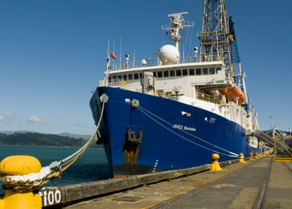
Expedition 329 - On this expedition an international team of scientists set sail on the scientific drilling vessel JOIDES Resolution and penetrated a total of 630 m at seven different drill sites to define the physical and chemical limits of subseafloor microbial life in tectonic and oceanographic settings not yet explored.
See full proceedings and details here(external link).
-
Wilkes Land glacial history
Expedition 318 - This expedition took cores from the seafloor to investigate when and why the ice sheet started growing on Antarctica and how the ice sheet has grown and melted during the last 35 million years. The team focused on learning about the interaction of climate, ice sheet growth, and ocean currents. The sediment cores we brought into the labs on the ship covered periods in Earth’s history that were extremely warm.
See the full proceedings and details here(external link).
-
Pacific equatorial age transect
Expedition 320 - During this expeditions two teams of about 29 scientists and 25 technicians worked together to drill and study cores of ooze and sediment at eight locations running northwest from just above the Equator. As the world’s largest ocean, the Pacific is intricately linked to major changes in our planet’s climate system. An understanding of the Pacific’s past or paleoclimate will improve our ability to model future climate change.
See the full proceedings and details here(external link).
-
Canterbury Basin sea level
Expedition 317 - On this expedition, the scientists investigated ancient changes in sea level. In other words, how deep was the ocean in the past? One way that we can get information about sea level is by studying cores of ice from the Antarctic. These ice cores are like a frozen snapshot of the past, and tell the scientists things like how much oxygen was in the oceans and what different chemical were present.
See the full proceedings and details here(external link).
-
Louisville Seamount Trail
Expedition 330 - This expedition aimed to better understand the movement and evolution of the hotspot that created this chain of underwater volcanoes. The JR drilled for cores at five different sites at depths of up to 1840 meters (6037 feet)! The data collected was compared with the better studied Hawaiian island-Emperor seamount trail to help determine if the chains of volcanoes created by hotspots are a result solely of the movement of the tectonic plate above the hotspot, or if the hotspots are also moving within the mantle.
See the full proceedings and details here(external link).