
Landslide Watch AotearoaDetecting and forecasting insidious landslide displacement
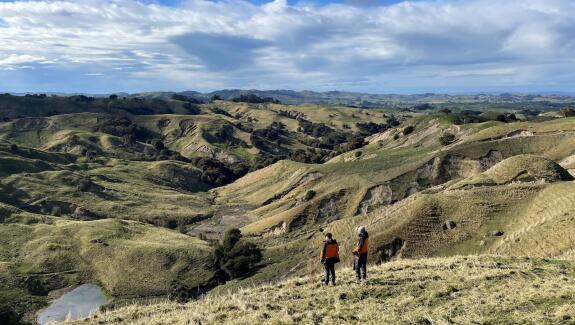
Aotearoa's steep terrain, heavy rainfall, and active tectonics make landslides its deadliest and most costly natural hazard. Much of the focus is on rapid landslides triggered by earthquakes and rain events, but the nation also faces a hidden danger: slow-moving landslides.
Often expansive and deep seated, these landslides can remain undiscovered for generations. When reactivated, they pose a threat to homes, infrastructure, and agricultural land. What’s more, these landslides can undergo catastrophic failure, transforming into damaging rapid landslides, as observed during Cyclone Gabrielle.
To improve our ability to live with these hidden hazards, we must first know where they are, whether they are active or not, and what drives their movement so we can forecast their behaviour. Rather than respond when they cause costly, disruptive and potentially life-threatening damage, we hope we can learn to avoid them or live with them.
Overview
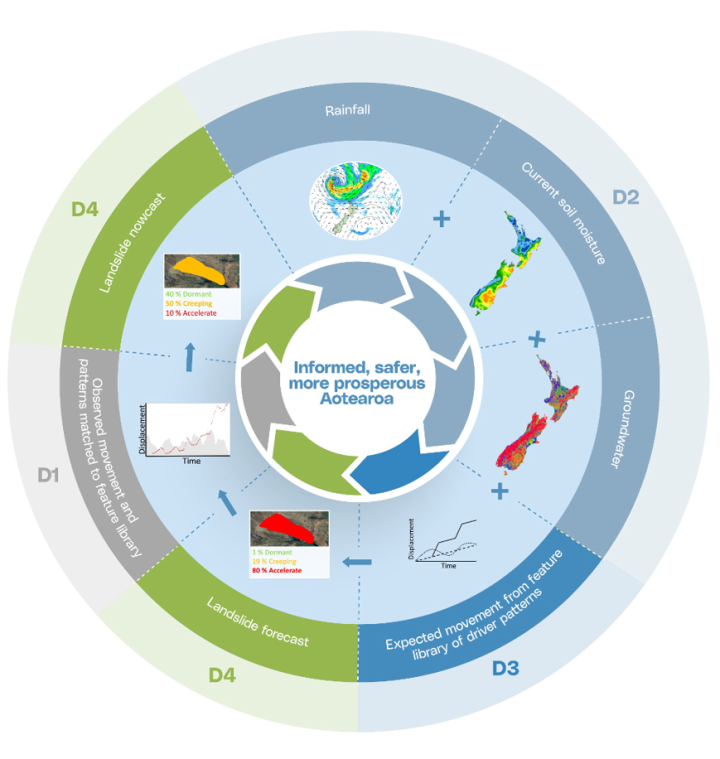
The goal of Landslide Watch Aotearoa is to develop a dynamic national landslide forecasting system. This system will use space-based observations to identify areas affected by slow-moving landslides, integrate climate science and geotechnical engineering to analyse the factors driving their movement, and leverage machine learning to predict the conditions under which they might transition into faster-moving slides and flows. Nationwide assessments will deliver suburb-level forecasts, modelling future movement under various climate scenarios. By pinpointing the locations of Aotearoa's hidden landslides, classifying their movement rates, and identifying the triggers that reactivate them, the system will enhance the ability to detect warning signs of potential acceleration events. This science is crucial for informing community preparedness, economic resilience, informed urban development, and successful mitigation efforts in Aotearoa.
Research questions
The programme will address four pivotal research questions:
- Where are Aotearoa’s large, slow-moving landslides?
- What are their movement ‘activity’ rates – how fast are the moving?
- What factors drive their movement?
- Under what conditions can they transition into fast-moving flows or avalanches?
Project deliverables
1. Identify and classify landslide displacement
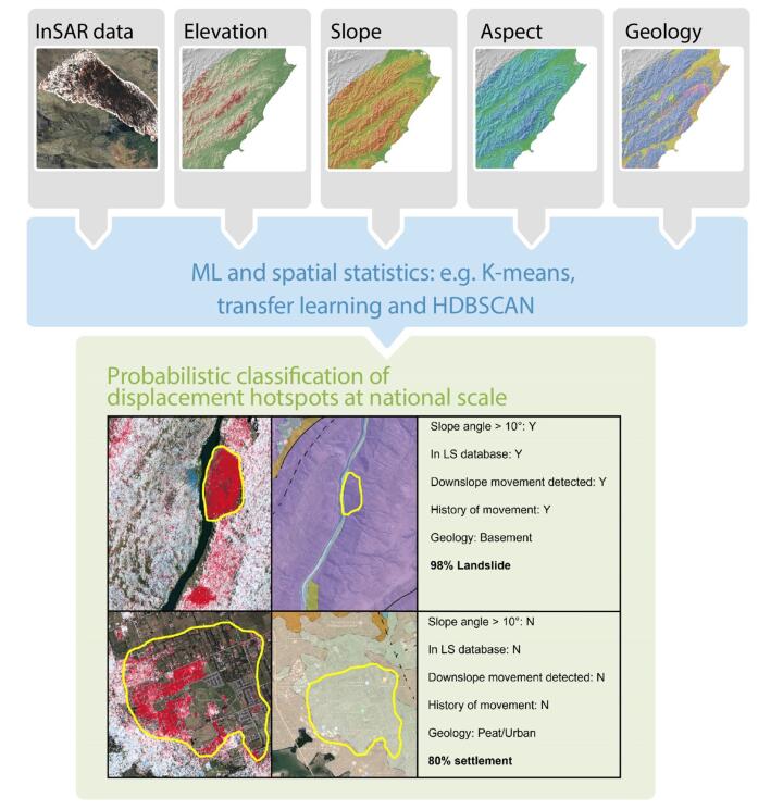
Nationwide spatiotemporal patterns of landslide displacement (i.e. when and where landslides occur) will be identified and classified as distinct from other types of ground displacement through the use of satellite data. This project will produce a nationwide map of ground displacement with the locations of large landslides defined and classified by type of landslide and the rate of movement – from e.g., inactive through to rapid.
Outputs
1) Geospatial national map of XYZ displacement and rates of displacement
2) Nationwide map of large landslides classified into type and movement rates
2. Define climate drivers
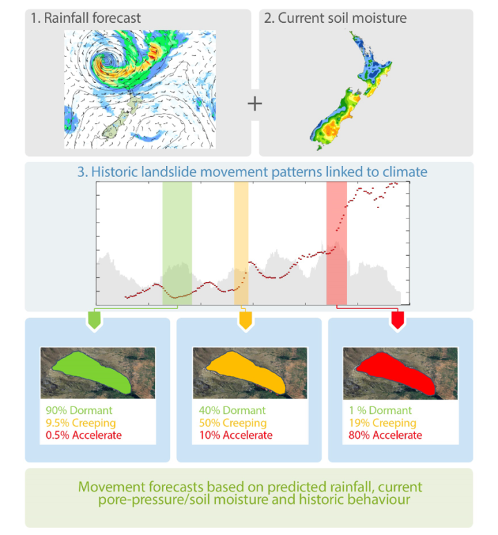
Historic, current and future climate processes and cycles will be developed and compiled to constrain our understanding of driving factors for landslide movement. This project will develop nationwide hindcasts (historic), nowcasts (near real-time), medium-term forecasts (35 days) and long-term forecasts (climate timescale) of climate processes focusing on key drivers of ground displacement – rain, soil moisture and groundwater. The dataset will represent areas with different geological and topographical settings across the different seasons and determine the steady state, the impacts of extreme seasonal weather and the effects of climate change on rain, soil moisture and groundwater.
Outputs
3) Nationwide groundwater, soil moisture, rainfall database
4) Narrative of link between climate drivers and landslide movement
3. Validate landslide displacement by hindcasting based on drivers and mechanisms
Physics-based modelling will be used to link the drivers of landslide displacement (rainfall, soil moisture and groundwater) to the material behaviour and failure mechanism of known and monitored landslides. The displacement patterns and changes over time with be linked to InSAR displacement data and time-series data to determine the precursory displacement patterns of slow to catastrophic landslide movement. If confirmed, the programme will explore whether the model can be trained to identify specific types of landslides and predict near and long-term future land displacement across New Zealand down to the suburb level.
Outputs
5) For a suite of case study landslides, the programme will provide a feature library linking rainfall, soil moisture and groundwater patterns to movement
4. Develop dynamic, nationwide forecasts of landslides
In consultation with end-users, this project will develop a variety of products that effectively communicate landslide nowcasts and forecasts in a way that delivers impact for New Zealand.
The products will include the public dissemination of forecasts and nowcasts, databases, models/algorithms, and geospatial datasets (including an Aotearoa-wide ground displacement map).
This project will also deliver scientifically and culturally informed Māori-led assessments on how climate-induced landslide hazards impact Māori and culturally significant sites and places. The programme will engage with the communities that are the most impacted to support the implementation of the findings into community preparedness plans.
Outputs
6) Nationwide dynamic nowcast maps
7) Nationwide dynamic forecast maps
8) Cultural impact case study
9) Nationwide landslide hazard resource targeting iwi Māori.
Case studies and data
The programme will merge national-scale InSAR data (satellite images that measure changes in ground deformation), physics-based landslide-mechanism models and new comprehensive climate-driving datasets covering all Aotearoa. This integrated approach will enable the programme to identify and classify landslides across diverse regions – specific to their geology and climate.
Several case study regions within Aotearoa and internationally, have been identified where existing data sets will allow us to validate the drivers, the observed displacement and to train AI models to establish feature libraries of landslide drivers, mechanisms and displacement patterns.
Combined with InSAR and climate data streams, the feature libraries will be used to find and identify similar driver and displacement patterns. Once the linkages between landslide displacement and climate drivers are quantified and validated using physics-based models, the programme will forecast and nowcast their movement under different climate change scenarios.
Results collected over the course of the programme will be shared with end users such as councils, land managers and emergency management groups to deliver benefits for New Zealand.
Nga Kōraherahe o Papatūānuku (The wrinkles of Mother Earth)
Landslides pose considerable threats to many culturally significant sites and the well-being of Māori communities across Aotearoa.
The programme includes a Māori-led initiative: Nga Kōraherahe o Papatūānuku (The wrinkles of Mother Earth) to develop a culturally inclusive landscape change and natural hazard framework that is connected to Māori philosophy and principles.
The initiative will identify vulnerable hapū and cultural areas and assist those affected to respond and adapt to landslide hazards.
The initiative comprises three workstreams, interwoven with the programme’s scientific aspect, grounded in a Te ao Māori perspective, and driven by Māori Masters students and local communities.
The Maori Masters’ students will:
1) conduct field studies to evaluate and forecast ground displacement and create maps depicting landslide hazards in the Whareponga Valley.
2) map landscapes, landmarks, and cultural factors of importance for landslide preparedness, and overlay these with the ground displacement maps. Employing the Te Whare Tapa Wha approach, they will gather cultural insights on landslides for future planning and iwi development, sharing acquired knowledge with affected hapū in the Whareponga area.
3) develop a forecasting tool to identify vulnerable Māori communities and culturally significant areas across Aotearoa. They will also create a communication framework to integrate into local emergency plans, iwi and hapū strategies, and community initiatives.
Funding and collaborators
This research programme is funded $10.6 million from the MBIE 2024 Endeavour Fund and will be conducted over a term of five years.
The programme is led by Earth Sciences NZ, with research partners University of Waikato, University of Canterbury, University of Leeds (UK), University of Oregon (US), University of California Santa Cruz (UCSC), University of Washington (US) and the Disaster Prevention Research Institute, Kyoto University (Japan).
Project leads

Project team
-
Earth Sciences NZ
- Chris Massey
- Ian Hamling
- Damon Clarke
- Katie Jones
- Danielle Lindsay
- Simon Cox
- Regine Morgenstern
- Alec Zoeller
- Wes Kitlasten
- Bilijana Lukovic
- Christina Magill
- Sara Harrison
- Conrad Burton
- Bipin Peethambaran
- Rasool Porhemmat
- Elizabeth Abbott
- Rogier Westerhoff
- Robert Buxton
- Te Aomania Te Koha
- Lydia DiCaprio
- Ashley Broadbent
- Trevor Carey-Smith
- Christian Zammit
- Tristan Meyers
- Kat Strachan
- Alfredo Jaramillo
-
External partners
- Tim Wright (University of Leeds)
- Andy Hooper (University of Leeds)
- Katherine Yates (University of Canterbury)
- Albert Bifet (University of Waikato)
- Gonghui Wang (Kyoto University)
- Joseph Wartman (University of Washington)
- Michael Olsen (Oregon State University)
- Noah Finnegan (University of California)
- Ben Leshchinsky (Oregon State University)
- Roger Fairclough (Neo Leaf Global Limited)
- David Petley (Nottingham Trent University)
- Rowena Lohman (Cornell University)
- Janusz Wasowski (CNR-IRPI (National Research Council - Institute for Geo-hydrological Protection)
- SatSense Limited