Kauaeranga River Flood Protection

flooding at rhodes park car park

State Highway 25 (SH25) is the main road in and out of Thames and provides critical access, including to its hospital. When the Kauaeranga River is in flood, the river overtops its banks into the Kauaeranga Spillway, forcing the closure of SH25. We worked with the Waikato Regional Council to help them better anticipate that action.

Overview

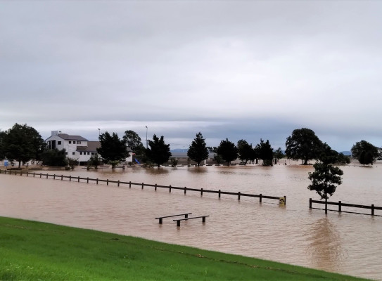
When large rainfall events cause the Kauaeranga River to flood, the river is designed to divert over a sports field and a section of SH25 just south of Thames township. When that happens, Thames is effectively cut off from the south.

The Kauaeranga Spillway is only used in rare/ infrequent extreme events (13 times in the last 30 years), but it is an essential tool to divert potentially damaging flood waters from residential and commercial properties.

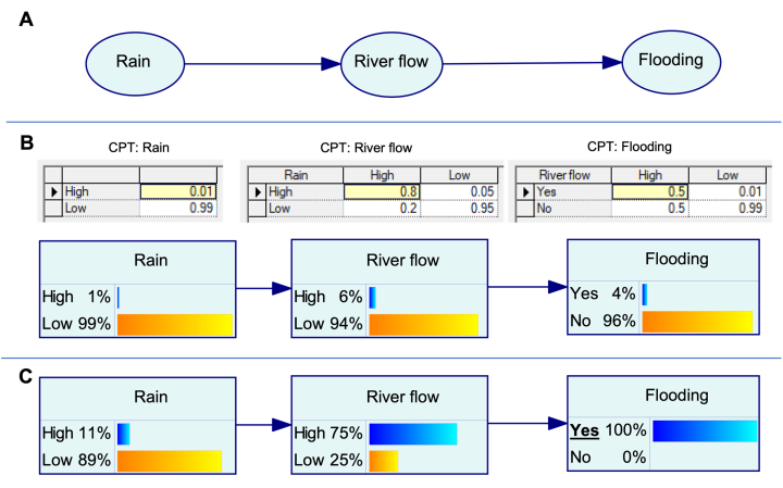
However, the Waikato Regional Council (WRC) find it difficult to predict in advance when the spillway will be operating, with monitoring techniques including six-hourly MetService warnings, precipitation, and river gauges, and ultimately in-person observation of river levels. WRC, working with Civil Defence and Waka Kotahi, has to put appropriate road management in place, and has very little time to alert affected communities.

Waikato Regional Council worked with GNS Science to help improve their emergency preparedness by coming up with a statistical model to answer this key question:

What is the likelihood that the Kauaeranga Spillway will be in operation [road inundated] in the next six hours?

The outcome

We developed a prototype model for the Waikato Regional Council to support its emergency preparedness and planning, using a Bayesian Network that identifies the likelihood of flooding/use of the Kauaeranga Spillway.

The process

A team from GNS Science worked with WRC to understand current procedures, the level of service required and factors influencing the operation of the spillway. The team analysed flooding events over the past 30 years and considered physical processes known to affect flooding. WRC provided expert knowledge of local conditions and physical processes that trigger operation of the spillway and the response.

The Project

The model we developed for Waikato Regional Council

The final prototype model uses eight variables, with the relationship between variables learned from data. It includes rainfall totals over 1-hour, 24-hour and 120-hour time periods, soil moisture, river height, and river flow – all of which play a factor in when the spillway may operate.

Kauaeranga River flood protection model summary (PDF, 519 KB)

Read the full report (PDF, 3.4 MB)

GNS Science supported this project through internal Strategic Science Investment Funding (SSIF) to develop more applied sciences tools for end-users such as regional councils. The SSIF funds strategic research that will have a long-term beneficial impact for our health, economy, environment and society.

What are Bayesian Networks?

A Bayesian Network is a probabilistic graphical modelling framework that can assess the likelihood of an event occurring, taking into account a number of influencing factors and conditions.

They enable us to add more value to our assessments because they allow for uncertainty and help us to identify sensitivities, even without a complete data set. We can also use qualitative local knowledge about particular conditions that affect the outcome. The fast calculations and the ease in which we can explore different scenarios help us to establish the appetite for risk that a stakeholder may have.

GNS Science has been developing this approach for risk assessment in carbon capture and storage, volcanic eruptions and most recently climate hazards.

Floods are New Zealand’s number one hazard in terms of frequency, loss and Civil Defence emergencies. With the increased risk due to climate change, we might use this approach to ask:

  • What is the likelihood of increased coastal erosion due to sea-level rise?
  • How will river flooding increase under different future climate scenarios?


Bayesian network example
Illustration of (A) a Bayesian Network (BN) structure with three nodes – “Rain”, “River flow” and “Flooding”, (B) Conditional Probability Tables (CPTs) associated with each node, where each variable has only two states, and the resulting joint probability distribution of all nodes, and (C) inference, where the observation of “Flooding” changes the probability distribution of the other notes.

Banner image credit: Thames-Coromandel District Council

Grant Georgia 2897

Georgia Grant Sedimentologist - Coastal Processes

Georgia is sedimentologist within the Surface Geoscience Department. Her research interests focus on climate variability in recent periods and past warmer climates, including Antarctic Ice Sheet and sea-level change. She analyses the statistical frequency of physical and geochemical characteristics of shallow-marine and deep-marine sediment cores.

View Bio Contact Me
Research project details

Collaborators: Waikato Regional Council

Duration
Funding platform

Strategic Science Investment Fund

Status

Completed

Leader

Georgia Grant

Funder

Ministry of Business, Innovation and Employment (MBIE)

By continuing with this download you agree to abide by the rules laid out in the Terms and conditions/Terms of use listed on this page.

If there are no specific Terms and conditions/Terms of use listed then please refer to our Copyright and Disclaimer page and Privacy Policy page

Download