Hawke’s Bay 3D Aquifer Mapping (3DAMP)
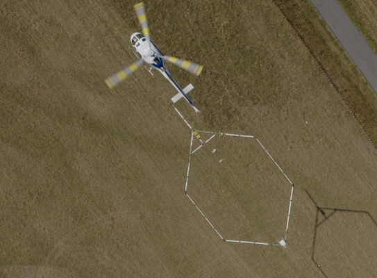
Hawke’s Bay is the first council in the country to use the latest airborne dual-moment time-domain electromagnetic survey technology (SkyTEM) to scan their aquifers to depths of ~300 m.
Overview
GNS Science and Hawke’s Bay Regional Council partnered on the largest-scale groundwater mapping project ever done in New Zealand. The Hawke’s Bay 3D Aquifer Mapping Project (3DAMP) is a four-year initiative (2019–2024) jointly funded by the Provincial Growth Fund, Hawke’s Bay Regional Council and GNS’ Groundwater Strategic Science Investment Fund (SSIF) research programme.
The 3DAMP project delivered a significant advancement in the detailed understanding of the region’s underground freshwater resources, enabling more effective management of these resources.
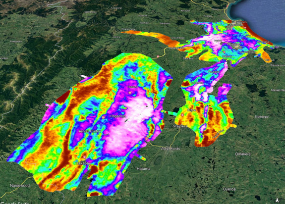
The project applied SkyTEM technology to improve mapping and modelling of groundwater resources specifically within the Heretaunga Plains, Ruataniwha Plains and Poukawa and Otane basins. 3DAMP involved collaboration between HBRC, GNS and the Aarhus University HydroGeophysics Group.
The SkyTEM system was developed by the Aarhus University HydroGeophysics Group in Denmark. It is a geophysical technique that uses electromagnetic waves to investigate the shallow (up to 500 m) resistivity structure of the earth. The SkyTEM system advances our ability to map aquifers from local to national scale, and enables refined decision-making tools that could be used by councils all over New Zealand.
Close to 8,000 line km of data were collected in Jan/Feb 2020 by SkyTEM Australia Pty Ltd. using a helicopter equipped with a SkyTEM system.
Using these data, electrical resistivity and hydrogeological models of the three areas were developed, and a subsequent groundwater flow model of the Heretaunga Plains that incorporated SkyTEM data.
Aims of the programme:
- enable Hawke's Bay Regional Council to better manage its water resources in line with community values and aspirations
- enable the Hawke’s Bay’s economy to further transition to high-value less animal-intensive, lower nutrient-producing activities
- develop methodologies to create decision-making tools that can be rolled out to other councils around New Zealand
To achieve these objectives
- SkyTEM data was collected across the Ruataniwha Plains, Heretaunga Plains and the Poukawa and Otane Basins
- pre-existing supporting data was compiled and assessed, and some additional data was collected through a drilling programme
- the SkyTEM data was processed and resistivity models were developed
- the resistivity models were analysed alongside the supporting datasets, from which hydrogeological models were developed
- the Hawke's Bay Regional Council’s numerical groundwater models in the Heretaunga Plains were updated with the data
- the developed models were made publicly accessible through online tools, for the general public via an ESRI storymap(external link), and for more technical users via the GNS dataset catalogue(external link).
Hawke's Bay 3D Aquifer Mapping project overview and update (HBRC, 2021)
GNS Science hydro-geophysicist Zara Rawlinson talks about the 3D Aquifer project at the 2020 New Zealand Hydrological Society, NZ Rivers Group and New Zealand Freshwater Sciences Society joint conference in Invercargill.
The project
Why use airborne electromagnetic data?
Traditional methods of gathering data from drilling or ground-based surveys are slow, costly, provide poor spatial data coverage, and generally don’t go deep enough.
Aerial mapping, on the other hand, can cover large areas of ground quickly and cost-effectively, giving high levels of detail on the subsurface. Developed by Aarhus University in Denmark, SkyTEM provides a 3D view of the subsurface to an average depth of around 300 m (depending on the noise and geology). In comparison, most available information from boreholes within the Heretaunga Plains is within the upper 50 m.
SkyTEM is an airborne dual-moment time-domain electromagnetic survey technology. Electromagnetic (EM) data is sensitive to rock type, porosity, permeability, clay content, moisture content, and properties of the water. These all help in understanding and mapping aquifers.
Adding more to the picture
Data was collected in January and February 2020. A drilling programme was undertaken in 2021 to collect additional data to support hydrogeological interpretations.
Through 2020 – 2022, GNS processed the SkyTEM data, primarily to remove EM noise, and developed electrical resistivity models. Through 2023-2024 GNS undertook hydrogeological interpretations of these data. In 2022-2024 GNS updated numerical groundwater models of the Heretaunga Plains using these interpretations.
GNS and HBRC also developed an online interface to provide easy access to the 3D models being developed.
Research project details
Collaborators: Hawkes Bay Regional Council, Aarhus University HydroGeophysics Group (Denmark)
Duration
2019–2024
Funding platform
MBIE-funded Provincial Growth Fund GNS Science’s (GNS)
MBIE-funded Groundwater Strategic Science Investment Fund (SSIF) research
Status
Current
Programme leader
Zara Rawlinson, GNS Science
Funder
New Zealand Ministry of Business, Innovation & Employment (MBIE), Hawke’s Bay Regional Council