GeoNet
GeoNet helps New Zealanders live with their natural hazards by providing information in usable forms and extending the two-way conversation on Aotearoa New Zealand’s hazards landscape.
Overview
GeoNet's systems provide New Zealanders with high quality open data for research and monitoring for all geological perils (earthquake, landslide, tsunami, and volcano).
GeoNet is a partnership between GNS Science, Natural Hazards Commission Toka Tū Ake, Toitū Te Whenua | Land Information New Zealand (LINZ), the National Emergency Management Agency (NEMA) and the Ministry of Business Innovation and Employment. The Natural Hazards Commission Toka Tū Ake has been GeoNet’s cornerstone funder since 2001.
GeoNet aims to
- collect and distribute high-quality, publicly available geohazard data
- support research into New Zealand’s geological systems and geohazards
- contribute to resilience and emergency management systems
- promote geohazard understanding in the public sphere
To achieve these objectives, we
- deploy, maintain, and upgrade assets to acquire, transport, collect, store, and distribute geohazards data – this includes sensors in the ground, such as seismographs, or in the water (tsunami gauges) as well as IT infrastructure
- monitor geohazards round-the-clock through the National Geohazards Monitoring Centre | Te Puna Mōrearea i te Rū (NGMC) and expert science panels
- respond to geohazard events by providing information and advice to NEMA through the NGMC and teams of on-call science experts – the GeoNet services support the provision of expert science advice from GNS to NEMA and others in the community
- engage with our wide range of users and the public through a range of media
The project
GeoNet – a world-leading system
Aotearoa New Zealand is prone to geological hazards, including earthquakes, landslides, tsunami, and volcanic activity. In 2000, GNS Science presented a plan that would provide timely, high quality data and information on geological hazards for research and emergency management. The Natural Hazards Commission Toka Tū Ake provided GNS Science funding to upgrade the national earthquake network and monitoring system, modernise data management practices and introduce new initiatives for volcano surveillance, landslide response and earth deformation monitoring.
Today, GeoNet has become a world-leading natural hazard monitoring system operated by GNS staff. The Natural Hazards Commission Toka Tū Ake, LINZ and GNS Science were the founding GeoNet partners with significant and sustained Natural Hazards Commission Toka Tū Ake investment providing GeoNet with a solid platform from which to develop. The LINZ investment ensured alignment with New Zealand’s geospatial data collection, and GNS has provided the expertise. More recently MBIE, representing NEMA, has funded the establishment of the NGMC. GeoNet contributes to a resilient and modern economy by providing datasets and infrastructure that:
- inform decision-makers, such as those who determine national insurance and reinsurance
- are the building blocks for hazard and risk models, including the National Seismic Hazard Model
- integrate and enrich other data platforms, such as New Zealand's geospatial infrastructure
- improve safety by enabling scientists to rapidly analyse ongoing geohazard events to support emergency management
- support public education about, awareness of and preparedness for New Zealand’s geohazards
Data for geohazards
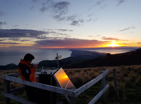
GeoNet uses remote and on-site methods to acquire and transport data about earthquakes, landslides, tsunami, and volcanoes. We deploy, maintain, and upgrade a range of instruments and infrastructure including:
- over 500 seismic broadband and strong motion sensors, to record earthquakes large and small
- Global Navigation Satellite System (GNSS) sensors, including those in the PositioNZ network, which record land deformation down to a few millimetres
- tsunami gauges and Deep-ocean Assessment and Reporting of Tsunami (DART) sensors that detect and record tsunami data both nearshore and further afield
- remote sensors and sensors for on-site sampling of geologic features – volcanic data acquired in this way include gas emissions, temperature recordings, and camera images
In addition to instruments and field-based infrastructure GeoNet also deploys, maintains, and upgrades a secure and resilient technical platform that enables data to be collected, processed into usable forms, and stored for use. Data is accessible through a range of mechanisms for a range of use cases from research to monitoring and response. GeoNet data is publicly available and aims to be Findable, Accessible, Interoperable, and Reusable (FAIR), so anyone from researchers and students to the public can benefit from this resource.
Geohazard monitoring and response
GeoNet is always ‘on’. GeoNet collects and monitors geological data and is prepared to respond to geohazards that could impact New Zealand. This starts with the National Geohazards Monitoring Centre | Te Puna Mōrearea I te Rū (NGMC), which ensures a 24/7/365 situational awareness of geohazards. The centre works with on-call science staff and expert panels who provide enhanced monitoring and escalation during geohazard event responses. Together, they support GNS Science in its role as a support agency in a geohazard event, providing prompt expert advice and intelligence about hazard events to external agencies, primarily NEMA.
The NGMC also monitors the outputs of international agencies to ensure awareness of international events that could impact New Zealand and to support understanding of events in New Zealand. GeoNet data feeding into international hazard monitoring organizations, like the International Seismological Centre in the United Kingdom and the Pacific Tsunami Warning Centre (PTWC, based in Honolulu, Hawaii), supports international monitoring and response initiatives that can benefit New Zealand.
Use of GeoNet data by national and international agencies and researchers helps grow our global understanding of geohazards and the risks they pose, which enhances development of techniques and products that improve monitoring and response by both the NGMC and expert panels. The resulting advice and products are accessed and used by a wide range of users from emergency managers to engineers, infrastructure managers, private companies, government planning, and insurance organisations.
Research programme details
Collaborators: Natural Hazards Commission Toka Tū Ake, Toitū Te Whenua | Land Information New Zealand (LINZ), the National Emergency Management Agency (NEMA), Ministry for Business Innovation and Employment, MetService, Department of Conservation.
Duration
2001 – present
Funding platform
Core funded through the Natural Hazards Commission Toka Tū Ake; various other funding sources
Status
Current
Programme leader
Catherine Ross, GNS Science
Funder
GeoNet is sponsored by the New Zealand Government through its agencies: Natural Hazards Commission Toka Tū Ake, GNS Science, Toitū Te Whenua Land Information New Zealand (LINZ), the National Emergency Management Agency (NEMA) and the Ministry of Business, Innovation and Employment (MBIE). Other national and regional organisations contribute according to hazard information requirements.