New Zealand Landslide Database webmap
Interactive web map
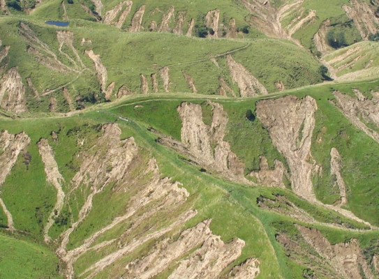
The New Zealand Landslide Database (NZLD) is a compilation of hundreds of thousands of landslides primarily triggered by high rainfall and significant earthquake events.
This database supersedes the (then) GNS Science NZLD released in 2017.
To engineer safer neighbourhoods and enduring infrastructure positioned among hilly landscapes prone to landslides, New Zealand needs robust landslide data to inform decisions on where and how we live.
This quality-assured database provides the crucial underpinning data critical for developing landslide hazard models, at all scales.
The New Zealand Landslide Database is viewable on an interactive webmap that can be accessed by anyone looking for past landslides at varying scales depending on the source data. The webmap is interoperable, so users can toggle on other datasets to offer a richer picture of spatial information.
New Zealand Landslide Database webmap tutorial
How to access the New Zealand Landslide Database
The NZLD can be accessed on the interactive webmap in two ways.
- Public non-registered users can view landslide points only.
- Public registered users can view all landslide feature classes (including polygons). Registration is free.
See the FAQs (external link) for information on data downloads.
-
What is the difference between a landslide point and polygon?
Points are a single point depicting the centre or crown of the landslide source or outline. Points are often used when there is no suitable imagery available to define the landslide source area, or to get a quick indication of the extent of landsliding in an event.
Polygons are closed shapes or areas on maps that show the boundaries of the area affected by the landslide, providing insights into the full extent and characteristics of the landslide source area and runout and its impacts.
Available features
The upgraded landslide database webmap includes related features like source areas and debris trails, with more consistent and detailed attributes than previous versions.
Key landslide attributes (where known) include:
- type of landslide as defined by the style of its movement down a slope, e.g., fall, flow, slide
- type of landslide triggering event, e.g., earthquake, rainfall
- date of occurrence
- activity type e.g., first time failure, reactivated
- size category, e.g., small, medium, large, giant
- a quality ranking of each dataset in the NZLD*
-
*Quality ranking
A quality ranking scheme has been developed (available in the associated data dictionary(external link)) to provide an overview of the quality of each dataset in the New Zealand Landslide Database. This is to acknowledge that landslides are mapped for different objectives, using different methods, and using different basemaps that have differing resolution and inherent uncertainty, which can all result in varying data quality. It incorporates information about the mapping method (basemap), scale, schema and locational accuracy and provides an overall categorical quality ranking between lower and highest for each dataset.
-
Limitations and considerations
The landslide locations presented on the webmap are derived from locational data of variable accuracy. Also some landslide features have been generalised to assist presentation. The data do not represent a complete inventory of all landslides that have ever occurred in New Zealand. The geospatial data in the webmap should be treated as an overview only. They should not be used as a substitute for detailed site mapping.
The New Zealand Landslide Database is a growing database and will be subject to change as new information becomes available and new interpretations are developed. Consequently, information presented on the webmap will also change.
-
Terms and conditions
The New Zealand Landslide Database (NZLD) displayed on this website was prepared by the New Zealand Institute for Earth Science Limited (Earth Sciences NZ)1. Metadata for the NZLD can be found at https://doi.org/10.21420/3s6h-2342(external link).
The New Zealand Landslide Database may not be used for commercial purposes.
The NZLD has been developed using the best data currently available. As we continuously improve our products, we reserve the right to amend the NZLD and/or any related data.
Earth Sciences NZ does not warrant or represent that the NZLD is accurate or complete, nor that it is fit for any purpose.
Under no circumstances will Earth Sciences NZ or its employees or agents be liable in contract, tort or otherwise for any loss, injury or damage (including loss of profits or consequential loss) which arises directly or indirectly from the supply by Earth Sciences NZ or its agents of the NZLD or any related data or information including inadequate, inaccurate or incorrect landslide information.
Earth Sciences NZ retains title to all intellectual property rights in the NZLD and related data, including copyright. Any modifications, developments or updates made by Earth Sciences NZ to the NZLD and related data will belong to Earth Sciences NZ.
Some aspects of the NZLD and related data were developed under contract (e.g. with local and/or regional councils) and should be used in conjunction with the associated report. Links to such reports, hosted by Earth Sciences NZ or available in the public domain, are provided in the webmap pop-ups, where possible. Further terms and conditions may apply to the use of those reports.
You must acknowledge Earth Sciences NZ as the source of the NZLD in any publication utilising information or data from the NZLD, including reports and media releases. To credit the use of the NZLD, please refer to the metadata found at https://doi.org/10.21420/3s6h-2342(external link).
Your acceptance of the enclosed material and/or services upon opening the NZLD webmap signifies your acceptance of these terms and conditions.
Please contact the NZLD administrator at landslide.database@gns.cri.nz if you have any concerns or further data requirements.
1 The New Zealand Institute for Earth Science Limited was established on 1 July 2025 by the merger of GNS Science and NIWA.
Resources
A data dictionary(external link) (Morgenstern et al. 2025) has been developed that documents the New Zealand Landslide Database structure, features and attributes and the relationships between them. This is intended to be used as a reference alongside the webmap.
Metadata for the NZLD, including how to credit the database and specific datasets in the database, can be accessed here(external link).
The NZLD GIS template can be made available. Please send an email request to landslide.database@gns.cri.nz.
-
Funding
The New Zealand Landslide Database update, data curation and redevelopment of the webmap has been funded by GeoNet. The datasets viewable in the webmap were generated from multiple sources, which were funded by various projects, all of which are acknowledged in the references associated with a given dataset.