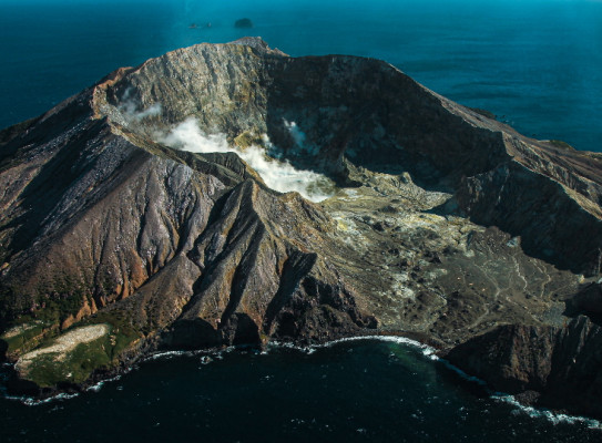
Beneath the waves

whakari white

This programme builds our preparedness and resilience to hazards from Aotearoa New Zealand’s near-shore volcanoes – Tuhua/Mayor Island and Whakaari/White Island.

Overview

Beneath the Waves is a GNS-led research programme with collaborators from University of Canterbury, Massey University, Victoria University of Wellington, East Coast Labs and Bay of Plenty Civil Defence and Emergency Management.

The project aims to

  • prepare one of the most populated areas of Aotearoa New Zealand for hazards from nearshore volcanoes

To achieve this objective, we will

  • explore the past and present states of Tuhua/Mayor Island and Whakaari/White Island
  • simulate the range of volcanic induced hazards from these islands
  • mitigate hazard impacts by ensuring our findings are communicated to diverse groups in appropriate ways

The project

The hazards of our nearshore volcanoes

There are two volcanoes lying just off the Bay of Plenty: Tuhua/Mayor Island and Whakaari/White Island. Geological evidence suggests that Tuhua has erupted at least 31 times in the last 64,000 years and may have erupted within the last 1000 years. The tragic eruption of Whakaari on December 9, 2019 was a stark reminder of the potential of our offshore volcanoes to cause serious harm, while the January 15, 2022 Hunga Tonga eruption has emphasised the global impact of eruptions from island volcanoes.

The Beneath the Waves programme seeks to fully understand the breadth of hazards posed by our nearshore volcanoes, how often they may erupt and what impact these eruptions and their associated hazards may have on the mainland (from ashfall to eruption or flank collapse induced tsunami waves). Understanding the full range of hazards from these volcanoes will allow for the development and long-term implementation of mitigation measures should an eruption event occur.

Our programme is guided by three research themes: explore, simulate, and mitigate.

Explore

Our programme will assess the current state of our nearshore volcanoes by locating magma reservoirs, hydrothermal systems, faults, areas of weak and strong rock.

To do this, we will be using RV Tangaroa, autonomous underwater vehicles (AUV) and remotely operated vehicles (ROV) to map the underwater and subsurface structure of the motu. Underwater measurements will be combined with equivalent on-land and airborne measurements.

To understand historic eruptions, we will examine seafloor sediments looking for ash layers from past eruptions to inform the likelihood of future eruptions as well as search for evidence of past hazard events such as large-scale tsunami generating flank collapse.

Simulate

Simulating hazards helps us understand their modes of occurrence and impact. Our programme will model the effects of eruptions, including ashfall and pyroclastic flow, using computer and large-scale analogue simulations. We will also model tsunami generation from volcanic sources and assess their ability to impact mainland New Zealand.

Specifically, we will:

  • develop large-scale physical hazard models using PELE, a large-scale laboratory for studying pyroclastic flows and their tsunami generation potential based at Massey University
  • numerically simulate volcanic source tsunami to develop a scenario database showing wave height generation for the North Island east coast
  • refine COMCOT (COrnell Multigrid COupled Tsunami) code from large-scale model simulations to better model volcanic-induced tsunami
  • develop probabilistic models of hazard occurrence
  • determine long-term eruption probabilities
  • construct a Bayesian Network for forecasting eruptions from Whakaari using monitoring data and expert judgement
  • develop detailed assessments of tsunami impacts on the Bay of Plenty coastline

Mitigate

We are committed to ensuring that the outputs of the programme are useful, usable and used. As such, a dedicated aspect of the programme is communicating our findings to diverse groups in appropriate ways. Our communication efforts will include (but will not be limited to):

  • natural hazards communication and education initiatives – “serious games” to engage rangatahi
  • hazard maps to convey spatial information for landowners and land use planners
  • online volcano “state of health” dashboards fed by monitoring data and Bayesian network forecasting
  • wananga and hui with iwi to collaborate, inform and translate the physical science in context of mātauranga Māori
  • scholarships to Te Whare Wānanga o Awanuiārangi to engage rangatahi in our work
Miller Craig 3156

Craig Miller Senior Volcano Geophysicist

Craig is a Senior Volcano Geophysicist specialising in application of geophysical potential field and electrical methods to model volcanic structure and time-varying processes. His research involves applying novel inversion techniques to image volcanic architecture and the use of data-driven models to interpret volcanic unrest in a probabilistic sense. He currently leads the Beneath the Waves Endeavour programme which aims to quantify hazards from New Zealand's near shore island volcanoes. He was worked on numerous volcanic eruptions and unrest episodes in NZ, Vanuatu and Chile and has been a member of the volcano duty team since 2003.

View Bio Contact Me
Research programme details
Duration

2021–2026

Funding platform

2021 Endeavour Research Programme

Status

Current/future

Programme leader

Craig Miller, GNS Science

Funder

MBIE

Find more content related to:

GNS Science topics

By continuing with this download you agree to abide by the rules laid out in the Terms and conditions/Terms of use listed on this page.

If there are no specific Terms and conditions/Terms of use listed then please refer to our Copyright and Disclaimer page and Privacy Policy page

Download