Solving the enigma of Tsunami earthquakes

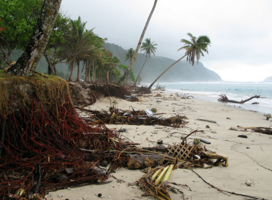
Tsunami damage, Lalomanu Beach, Samoa

This project seeks to understand what plate boundary properties promote their occurrence and where Tsunami earthquakes pose a significant but potentially underrated hazard to coastal populations.

Overview

Tsunami earthquakes are shallow, long-duration earthquakes at subduction zones that generate disproportionately large tsunami relative to earthquake magnitude. Such earthquakes pose a large hazard to coastal populations, as the ground shaking is typically not sufficient to prompt self-evacuation prior to the arrival of the tsunami.

A major unknown in global hazard models is whether the risk of Tsunami earthquakes is prevalent across all subduction zones or is only locally heightened by unique physical characteristics. We have identified a global paradox whereby the topography overlying Tsunami earthquake zones is steeper than would be expected if the subduction fault is weak, as minimal ground shaking would suggest. We will test contrasting physical interpretations of this paradox by integrating new electromagnetic data with cutting-edge processing of marine seismic data along New Zealand’s Hikurangi margin. This is the first time these complementary datasets have been available for any subduction zone and will provide our team with unprecedented constraints on the physical environment of Tsunami earthquakes.

The project aims to

  • obtain unprecedented physical constraints on the source environment of Tsunami earthquakes from new geophysical data
  • clarify what physical characteristics either promote or reflect the occurrence of tsunami earthquakes
  • significantly improve local (Hikurangi) and global assessment of the hazards they pose

To achieve these objectives, we are

  • integrating seismic and electromagnetic data along the Hikurangi margin
  • comparing tsunami earthquake zones in New Zealand and Nicaragua
  • investigating the use of structural proxies to identify tsunami earthquake zones globally

The project

When ‘long or strong, get gone’ doesn’t fit

Tsunami earthquakes are fault ruptures that are fast enough to generate a tsunami, but slow enough to limit the production of seismic energy needed to trigger tsunami warning systems or prompt self-evacuation. They occupy a poorly understood middle ground, and present an underrated hazard, especially for New Zealand communities schooled to use the civil defence rule-of-thumb Long or strong, get gone.

New Zealand's Hidden Megathrust Fault – The Hikurangi plate boundary, located off the East Coast of the North Island, is where the Pacific tectonic plate subducts the Australian tectonic plate. transcript

So here we are at Turakirae head on the south coast of the north of New Zealand, and here we can see stunning physical evidence of past large earthquakes.

Now I'm standing on a gravel Ridge and amongst these stones we see fossil shells that tell us this red was once down by sea level.

So we can see in these images a whole series of these lines along the coastline of bear rock, and each of these lines represents a raised beach.

The beach that we're standing on right now was actually raised in a massive magnitude 8.2 earthquake on the Wairarapa fault in 1855 ad.

It raised this part of the coastline by six point four meters the horizontal movement was 16 meters along a hundred and twenty kilometer length of fault line. This earthquake also triggered a massive tsunami that was 10 meters high.

So that's one of the largest events we could ever see in New Zealand? No. Because actually right beneath me here is New Zealand's largest fault. About 20 kilometers down as the Hikurangi subduction zone and this marks the boundary where the Pacific plate meets the Australian plate and they crash together.

The Pacific plate is actually being pushed down beneath the Australian plate creating a giant fault surface. These subduction zone boundaries caused the largest earthquakes and tsunamis that we've ever seen around the world. For example in Japan and 2011 also in Sumatra in 2004.

Here in New Zealand this fault extends across the whole of the eastern North Island from Marlborough in the south, to East Cape in the north. Its vital for us to better understand the zone in order to deal with the hazard it poses to us.

The New Zealand government has funded a five-year research program to really delve into some of these questions. We want to investigate how the plates are moving right now and in current times, we want to know the structure of the plate and how they're interacting, we also want to look at past earthquake records like we see here.

Where these earthquakes occurred how big as they've been and what other hazards such as tsunamis and landslides have they triggered.

New Zealand's Hidden Megathrust Fault

The Hikurangi plate boundary, located off the East Coast of the North Island, is where the Pacific tectonic plate subducts the Australian tectonic plate.

The Hikurangi Subduction Zone project – The Hikurangi Project is a multinational science investigation of the subduction zone beneath New Zealand's North Island. transcript

In the North Island of New Zealand we have what is New Zealand's largest plate-boundary fault. It's called the Hikurangi Subduction Zone.

It's accommodating westward subduction of the Pacific Plate beneath the eastern part of the North Island.

This subduction zone is, for a number of reasons, attracting a huge amount of international attention because scientists all over the world are realizing that there are many characteristics of this plate boundary that can give us a lot of insights into why large earthquakes happen on these types of plate boundaries and why tsunamis are generated.

There are a huge number of experiments going on that involve many many scientists from all over the world to try and better understand this really important Plate Boundary Fault.

The Hikurangi Subduction Zone project

The Hikurangi Project is a multinational science investigation of the subduction zone beneath New Zealand's North Island.

Understanding how, why and where tsunami earthquakes are generated

There are some 51,000 kilometres of subduction plate boundary on Earth. So far, only 3% of this length has demonstrated the capacity for generating tsunami earthquakes. However, an additional 15% shows a similar structure to known tsunami earthquake zones.

The project, led by GNS Science, will bring together international researchers in several geoscience specialties. They aim to better understand the physical processes that predispose areas of subduction zones to the occurrence of tsunami earthquakes.

The tsunami earthquake project is focused on the Hikurangi subduction zone – known to be potentially New Zealand’s largest source of geohazards – where the Pacific Plate descends beneath the North Island, just off the East Coast. Two Tsunami earthquakes were generated in 1947 from locations offshore Tolaga and Poverty Bay.

  • Publications

    Chesley, C., Naif, S., Key, K., & Bassett, D. (2021). Fluid-rich subducting topography generates anomalous forearc porosity. Nature, 595(7866), 255-260.

Bassett Dan 2703

Dan Bassett Marine Geophysicist

Dan is a Marine Geophysicist with broad interests in the structure, dynamics and slip-behaviour of subduction zones. Dans primary interest lies in using marine geophysical methods to produce detailed images of the Earth’s crust. I integrate these models with geologic, earthquake and geodetic data to investigate the physical mechanisms that control fault slip behaviour.

View Bio Contact Me
Research project details

Collaborators: University of Texas at Austin, Georgia Tech, Lamont Doherty Earth Observatory

Duration

2020–2023

Funding platform

Marsden Fund

Status

Current

Programme leader

Dan Bassett, GNS Science

Funder

Marsden Fund

By continuing with this download you agree to abide by the rules laid out in the Terms and conditions/Terms of use listed on this page.

If there are no specific Terms and conditions/Terms of use listed then please refer to our Copyright and Disclaimer page and Privacy Policy page

Download