
Aggregate modelling
GNS Science has produced the first national assessment of aggregate opportunities to help decision-making for infrastructure and land-use planning.
Overview
Each year Aotearoa New Zealand consumes the equivalent of eight tonnes of aggregate per person across roading, construction and other infrastructure projects. The need for aggregate is increasing in high-growth areas, such as Auckland, Wellington and Christchurch. We need both existing and new quarries to meet this demand.
We produce about 41m tonnes of rock, sand and gravel aggregate each year, with:
- 62% for roading
- 27% to building
- 1% for reclamation and protection
- 10% for fill
That roading figure highlights the importance of infrastructure for future aggregate demand, particularly in our major cities. The North Island accounts for 40% of that 41m tonnes.
The project aimed to
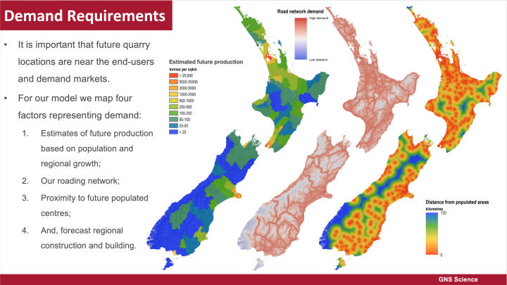
- model New Zealand’s potential quarry sites using maps of:
- gravel and hard rock source rocks
- physical, cultural and economic criteria
- aggregate transport costs
- community sensitivities
- and, protected land
To achieve this objective, we
- sourced data from Land Information New Zealand, the Department of Conservation, Manaaki Whenua Landcare Research, GNS Science, the Ministry for the Environment, Statistics New Zealand
- used Geographic Information System (GIS) software to create the maps
- took advice from industry experts and spatial statistics generated from 200 operating quarries
The resulting model identified “goldilocks zones” that highlight areas that may provide high-quality raw material and keep costs down, while also minimising factors such as noise, dust and heavy vehicles near built-up areas.
The New Zealand Infrastructure Commission Te Waihanga funded this report, and the Aggregate and Quarry Association supported the project.
The project
Our new aggregate model
Our new model is what we call an “aggregate opportunity concept”. It includes the features necessary for a quarry to succeed, and the factors that affect its viability or development.
Our model includes:
- a predictive model includes 23 mappable layers divided into five components of source rocks, land use, demand requirements, infrastructure, and cultural sensitivity
- we particularly include areas where quarrying is prohibited or restricted, such as on conservation land, and use interpretations of satellite data to classify areas of significant high-value indigenous vegetation
- the resulting product includes a detailed report, 21 printable maps covering the entire country showing areas of aggregate opportunity and a GIS that contains all the data in case end-users would like to interpret the product in more detail
These resources are a powerful tool for council land-use planning now and in the future. They lay out guides for potential future quarry developments and identify areas that could supply major infrastructure projects.

Why we need such a model
We need a national-scale model of aggregate opportunities which can be investigated before being allocated to other land use. The 2021 updated models show these areas and where follow-up studies would provide more insight into their potential.
Our economy is demanding large quantities of industrial minerals and aggregate for building, roads and agriculture. Efficient use of our aggregate resources is critical to reducing costs and transport emissions. Long-distance transport is generally uneconomic, so sources of aggregate are required near the end users.
Managing the future demand requirements and planning for aggregate supply is essential.
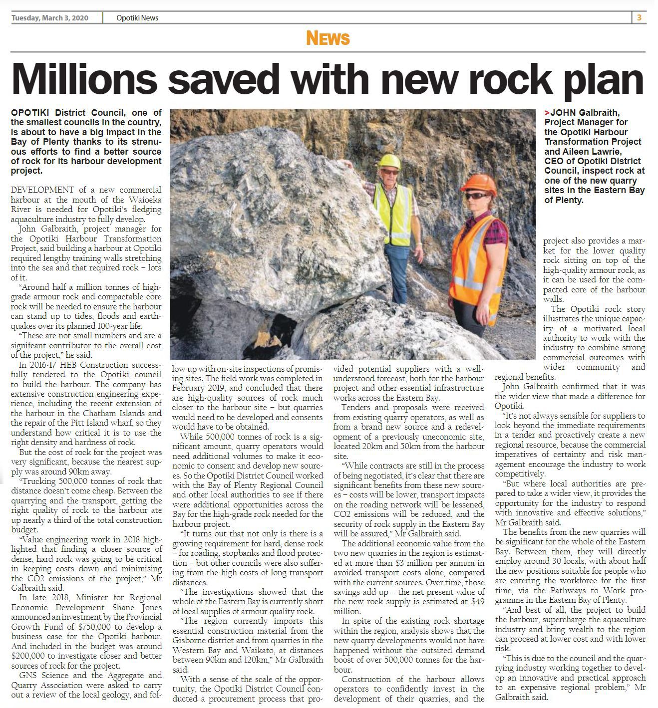
Helping out in Ōpōtiki
Ōpōtiki’s new harbour is fundamental to its economic and social advancement. However, the budget was blowing out because of transport costs.
We mentioned transport costs earlier; every 30km they double. Initial cost estimates for the Ōpōtiki harbour project estimated that aggregates needed to be trucked in over long distances for the project so finding local source would be a financial game-changer.
We joined forces with the Aggregate and Quarry Association to find a solution. Together, we identified several new local quarry sites, helping to nearly halve the projected cost of aggregates.
The carbon connection
Aggregate rock resources such as dunite and basalt can also be identified from this model. These are critical materials for new carbon capture techniques such as enhanced rock weathering, a technology that GNS Science are assisting research into.