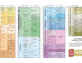
Stratigraphy
Explore the history of Aotearoa New Zealand's crustal surface using this geological legend showing the ages of the rocks in order.
Against each age is a summary of the major rock types, their distribution, content, deformation qualities and the conditions that gave rise to them.
Stratigraphy is the study of the sequence of rock layers in an area.
These are generally described from the oldest to the youngest. The information on age, environment of deposition or mode of formation comes from the rocks themselves or their relationships to one another.
Explore Aotearoa's geological history in its stratigraphy below...
-
Cambrian (Z)
Distribution
Cambrian rocks are certainly known only from the northwest of the South Island, between the Aorere River and Maruia Springs. Cambrian rocks may also exist in Fiordland.Content
In northwest Nelson the rock types are very varied, with slate, argillite, chert, hard sandstone, limestone lenses, and widespread conglomerate, all of sedimentary origin. New Zealand's oldest fossils, trilobites, are preserved in Cambrian limestone in the Nelson district. Basalt, andesite, and tuff represent widespread volcanic activity at this time. In the upper Takaka River, a layered igneous complex of serpentinised peridotite, gabbro, and diorite was intruded at this time. Most of the rocks are metamorphosed to some extent, in particular the volcanics, but in most places the parent rocks can be recognised. In Fiordland, possible Cambrian rocks include schist and gneiss.Paleogeographic conditions
The sediments were deposited in a shallow marine environment on the flanks of a volcanic arc, offshore from Gondwanaland. The widespread conglomerate formation represents a deltaic fan. At this time the Fiordland area lay close to northwest Nelson and it is likely similar conditions prevailed.Deformation
All the Cambrian rocks are complexly deformed by several phases of deformation. In particular large scale thrusting of "loops" of sediment many kilometres from their original site is evident. Tight folding and shearing of sediments is common. -
Ordovician (O)
Distribution
Ordovician rocks are found in the western South Island and southern Fiordland.Content
Limestone and marble are characteristic of the Ordovician in northwest Nelson, with the marble being particularly well exposed on Takaka Hill. Hard sandstone, argillite, black shale, and white quartzite bands occur mainly to the west of the limestone. Many of these lithologies are metamorphosed to some degree. Alternating hard sandstone and argillite extend down the South Island West Coast as far as Milford Sound. Rocks at Preservation Inlet in southern Fiordland have Ordovician fossils.Paleogeographic conditions
The sandstone and argillite were deposited in a fairly deep trough lying offshore from Gondwanaland, while the limestone was deposited on the Cambrian volcanic chain which had become extinct.Deformation
The Ordovician rocks in northwest Nelson are complexly deformed and some were also involved in the major thrusting which affected Cambrian rocks. The Ordovician rocks further south are not as deformed, but tend to be steeply dipping and in places tightly folded. -
Silurian (S)
Distribution
Silurian rocks occur in Nelson, Stewart Island and probably in Fiordland.Content
Silurian rocks are dominantly quartzite, with minor argillite and limestone. The equivalent metamorphic rocks known from Nelson and Stewart Island are schist, gneiss and amphibolite.Paleogeographic conditions
The Silurian and Devonian sedimentary rocks were the final deposits of the offshore trough which had existed throughout the early Paleozoic. Crustal movements generated magma which penetrated the sedimentary pile, and eventually cooled to become the large batholiths of granite, granodiorite, and diorite. The resulting pressure and heat were responsible for much of the metamorphism of the lower Paleozoic rocks.Deformation
The crustal movements in the Devonian (and continuing intermittently through to the Permian - Tuhua Orogeny) were largely responsible for the deformation of the lower Paleozoic rocks. On the whole, the Silurian and Devonian rocks were not involved in the earlier major thrusting events, but they are faulted and tightly folded. -
Devonian (D)
Distribution
Devonian rocks are present in the Nelson region and near Reefton. Rocks of this age also occur on Stewart Island and probably in Fiordland. Many igneous intrusions in the South Island, from the Nelson region down to Stewart Island, are of Devonian age.Content
Devonian rocks are more varied than Silurian rocks, with calcareous mudstone, sandstone, and conglomerate in the northwest Nelson area. Near Reefton quartzite, limestone, and mudstone are the dominant rock types.Large granite and granodiorite intrusions occurred in the Devonian, mainly as the Karamea Batholith in the northwest of the South Island, and also as smaller intrusions further south. South of Riwaka in the Nelson area, a basic complex of gabbro, peridotite, and diorite is of Devonian age.
Paleogeographic conditions
The Silurian and Devonian sedimentary rocks were the final deposits of the offshore trough which had existed throughout the early Paleozoic. Crustal movements generated magma which penetrated the sedimentary pile, and eventually cooled to become the large batholiths of granite, granodiorite, and diorite. The resulting pressure and heat were responsible for much of the metamorphism of the lower Paleozoic rocks.Deformation
The crustal movements in the Devonian (and continuing intermittently through to the Permian - Tuhua Orogeny) were largely responsible for the deformation of the lower Paleozoic rocks. On the whole, the Silurian and Devonian rocks were not involved in the earlier major thrusting events, but they are faulted and tightly folded. -
Carboniferous (C)
Distribution
The only known Carboniferous fossil localities occur in sedimentary rocks in south Canterbury and north Otago, within the greywacke. Several of the granite plutons mapped on Stewart Island are also of this age, but they are not shown separately on the map.Content
Greywacke consists of hard grey sandstone and darker coloured mudstone (argillite). These generally form alternating sequences with the sandstone predominant. In southern Canterbury, the Carboniferous fossil locality is in limestone within a melange unit. In north Otago, Carboniferous fossils have been recorded from interbedded marble and chert.On Stewart Island, granite and granodiorite, together with foliated rocks of similar compositions (gneisses) occur among much younger intrusive rocks.
Paleogeographic conditions
Carboniferous sedimentary rocks were deposited in a marine environment, possibly in an enormous submarine trough or series of basins.Deformation
The greywacke rocks are commonly extremely deformed, fractured, and veined, and in some areas it is difficult to see original sedimentary features because of this severe deformation. -
Greywacke
This rock type, or association of rocks, is found in many areas of New Zealand and spans from Carboniferous to Early Cretaceous in age. A general summary is given in this section. Greywacke rocks in the South Island are subdivided into major blocks known as the Caples and Torlesse terranes, while those of the the North Island are divided into Torlesse and Waipapa terranes.
Content
The dominant rock types are hard grey sandstone and darker coloured mudstone (argillite). These generally form alternating sequences with the sandstone predominant, and together the sandstone and mudstone are often referred to jointly as "greywacke". Minor rock types found interbedded with, or faulted into, the greywacke include limestone, chert, conglomerate, spilite, and chaotic units of melange and broken formation.Metamorphic rocks present in the South Island, west coast of Wellington and the Kaimanawa Mountains are thought to be metamorphic equivalents of greywacke, and of the same age range. The boundary between greywacke and schist is transitional and in the less metamorphosed part of the sequence, sedimentary features from the parent rock can still be seen. These sedimentary features become obliterated as the metamorphic grade increases. Metamorphosed volcanic bands become a characteristic green colour (greenschist). Most of the schist in Otago and Marlborough falls into the chlorite metamorphic zone, which itself is divided into three sub-zones depending on the metamorphic minerals which develop in the rock as the metamorphic grade increases. The highest metamorphic grades (biotite, garnet, and oligoclase) are restricted to the western parts of Otago and the Southern Alps.
Although the greywacke rocks contain few age-diagnostic fossils there does seem to be a general pattern of age distribution. In north Otago and south Canterbury, rare Carboniferous fossils are recorded. Permian fossils are present in the same general area including the Waitaki valley, and it appears that this area has the oldest greywacke. Further west and north into mid Canterbury, Triassic fossils are present, while further north again into north Canterbury and Marlborough, Jurassic and Early Cretaceous fossils occur, demonstrating a general younging trend to the north and east.
In the North Island, the main Tararua, Ruahine, and Kaimanawa ranges appear to be mainly Triassic to Jurassic in age while the Wairarapa and Raukumara greywacke ranges to the east and northeast are younger (Jurassic to Early Cretaceous). Northland, Auckland and Coromandel have greywacke of Triassic to Jurassic age.
Deformation
Greywacke rocks are commonly extremely deformed, fractured, and veined, and mudstone in particular is commonly very sheared. Some deformation took place within the sedimentary pile, but the severe folding, faulting, and shearing were caused by the mountain-building episode of the Rangitata Orogeny, and the rocks were further deformed by the later Kaikoura Orogeny. In many areas it is difficult to see original sedimentary features because of severe deformation. -
Permian (Y)
Distribution
Sedimentary rocks of Permian age are present in the north of the South Island and in a broad band extending from northwestern Otago through Southland to the east coast, south of Dunedin. Permian igneous rocks have a similar distribution. It is thought that Permian rocks exist offshore to the west of Kawhia and Taranaki. A separate group of Permian sedimentary rocks, part of the greywacke belt, occurs in north Otago, south Canterbury, Marlborough, central North Island and the Bay of Islands (see Greywacke).Content
The first group of sedimentary rocks mentioned above have a very high content of volcanic-derived fragments (volcanogenic), but are otherwise quite variable. In the Nelson area they include fossiliferous conglomerate, sandstone, mudstone and limestone, some slightly metamorphosed. Interbedded tuff and more rarely layers of basalt are also found. A very similar sequence occurs in northwestern Otago and northern Southland.Volcanic rocks are intimately associated with sedimentary rocks in both the Nelson and Southland regions, although they are more prominent in the south where they form the bulk of the Takitimu Mountains and extend in a thin band north through the Eglinton and Hollyford valleys. The volcanics comprise basalt, andesite, porphyry, volcanic breccia, tuff, and minor interbedded sediments.
The Permian greywacke rocks consist of hard grey sandstone and darker coloured mudstone
The Permian time period is also represented by an association of rocks known as an ophiolite assemblage, composed of deep water sediment, submarine basalt, and very basic plutonic rocks occurring in long narrow belts. These rocks represent a slice of sea floor that made up an old subduction zone. The Permian ophiolite assemblages are recognised in Nelson and Otago. In Nelson the plutonic rocks comprise gabbro, dunite (named from Dun Mountain), peridotite, and serpentinite. In this area some parts of the original layered plutonic complex have been deformed by later tectonic events so as to break up into large blocks in a chaotic manner. This chaotic mass is called a melange and is characterised by the widespread occurrence of serpentine. The melange belt extends to the north and south of the recognised ophiolite sequence of the Dun Mountain-Red Hills area. In northwestern Otago the ophiolite assemblage is best seen at Red Mountain which is composed of peridotite, dunite, and serpentinite, and extends south and east in a belt. In both areas the assemblage is known as the Dun Mountain Ophiolite Belt, and lies adjacent to Permian sedimentary rocks.
The basic plutonic complexes of the Longwood Range and Bluff are of Permian age. These comprise gabbro and peridotite as the main rock types, and are probably associated with the volcanics of the Takitimu Mountains.
At Parapara Peak, northwest Nelson, is an important occurrence of Permian freshwater and shallow marine rocks which have no volcanic content.
Paleogeographic conditions
Following the events of the Tuhua Orogeny, which formed new continental crust on the edge of Gondwanaland, a volcanic arc developed offshore. To the east of the arc a marine sedimentary basin developed. Some Permian rocks were deposited on the edges of this basin, close to the volcanic arc, and rocks with a lesser volcanic content were deposited in deeper water and further from the arc. A subduction zone east of the continental margin was actively drawing down oceanic crust, causing the volcanic activity and a trench to develop above it. The "fossil" subduction zone is represented by the Dun Mountain ophiolite belt. The small area of rocks at Parapara Peak represents deposition adjacent to the continent to the west of the subduction zone.The Permian greywacke rocks were deposited in a different setting from the volcanogenic rocks, as they have different mineral content and rock detritus. The setting was either a different part of the marine basin mentioned above, or a different part of the ocean floor altogether. The source of the rock detritus may have been the lands that later became Australia or Antarctica. The different Permian rock types were later brought together by tectonic movements.
Deformation
Some of the Permian rocks are part of a major downfold (syncline) structure also involving the younger Triassic and Jurassic rocks in Nelson and Southland. Within the major structure the rocks are commonly tightly folded with steep dips. Locally there are areas of shearing and major faulting. The greywacke rocks are also very deformed, with many crush zones and faults, and some have been metamorphosed into schist. -
Triassic (T)
Distribution
Triassic rocks have a similar distribution pattern to Permian rocks in the South Island (i.e., Nelson and Southland). However, they also occur in the west of the North Island, from northern Taranaki to the Waikato River. Triassic rocks of the greywacke belt occur in Otago, Canterbury, Marlborough, the axial ranges of the North Island and Northland.Content
The Triassic rocks are similar to the Permian rocks. Conglomerate, sandstone, and mudstone, mainly derived from volcanic rock types, are common, while tuff beds are widespread particularly in the North Island; volcanic flow rocks are rare. In places the rocks are very fossiliferous giving good age control.The greywacke belt rocks are grey sandstone and mudstone, with minor limestone, chert, conglomerate, spilite, and melange (see Greywacke).
Paleogeographic conditions
All Triassic rocks of New Zealand are marine, with the same depositional environments and volcanic activity continuing from the Permian. Rock units with significant quantities of conglomerate indicate closeness to a land mass.Deformation
Triassic rocks are involved in the major downfolds of the Kawhia, Nelson, and Southland regional synclines. In Southland and Kawhia the rocks are not highly deformed, but in the main only gently folded. In Nelson the syncline is severely faulted. The greywacke rocks are also very deformed, with many crush zones and faults, and some have been metamorphosed into schist, especially in Otago and Nelson. The Otago (Haast) Schist forms a belt which crosses the southern part of the South Island from east to west, then curves north to trend northeast in a narrow wedge. Schist is also present locally near Wellington and in the Kaimanawa Mountains. -
Jurassic (J)
Distribution
Jurassic rocks are widespread in Southland, and there are smaller areas near the Pyke River in northwestern Otago and in Nelson. They are well represented in the Waikato area. Jurassic rocks of the greywacke belt occur in north Canterbury, Marlborough, Wairarapa to East Cape and Northland.Content
Jurassic rocks are mainly sandstone, mudstone, and conglomerate, with tuff (ash) bands. Freshwater sandstone and conglomerate with plant fossils and minor coal seams occur in both Southland and Waikato. The greywacke belt rocks are grey sandstone and mudstone, with minor limestone, chert, conglomerate, spilite, and melange.Paleogeographic conditions
The Jurassic sediments of Southland and Waikato were laid down on an ever-shallowing shelf, over which sea level oscillated so that at some times marine conditions prevailed and at others the shelf was above sea level. The response to the lower sea levels was rapid downcutting by rivers and associated influxes of gravel to the marine basins. Volcanic activity had almost ceased. The greywacke rocks were deposited in a submarine trough or series of basins.Deformation
Jurassic rocks are generally gently folded and form the core of the Kawhia and Southland syncline. The Jurassic in Nelson and northern Fiordland is severely faulted. The greywacke belt rocks are folded and faulted, though in many places not quite as deformed as the older Triassic greywackes. -
Cretaceous (K)
Distribution
Cretaceous sedimentary rocks are widespread, and are exposed in Northland, East Cape, Wairarapa, Marlborough, Westland, Canterbury and Otago. A feature of Cretaceous time was igneous activity, and granite occurs in many places in the South Island, while volcanic rocks are widespread in Northland, East Cape, Marlborough and parts of Canterbury.Content
The Cretaceous was a time of widely differing depositional environments resulting in varied rock types. In the Marlborough, Wairarapa, and East Cape regions, greywacke deposition continued and plant fossils of late Early Cretaceous time have been found in some of these rocks. Marine fossils of Early to middle Cretaceous age have been found in Marlborough, Wairarapa and East Cape. These rocks, although similar in appearance to the bulk of the greywacke (i.e., sandstone and mudstone), are actually softer and deformed quite differently, with slump folds and internal folding indicating deformation while the rocks were still soft. Other rocks of mid-Cretaceous age in Northland, East Cape, Wairarapa, and Marlborough are undeformed alternating sandstone and mudstone with chert, limestone, and spilite beds. Towards the end of the Cretaceous some areas may have been briefly emergent, but by the end of the Cretaceous there was a return to marine conditions, and the sediments deposited then were sandstone, commonly glauconitic (greensand), and siliceous mudstone.The only fossils of land-dwelling dinosaurs in New Zealand are preserved in Late Cretaceous rocks of inland Hawkes Bay. Large marine saurian fossils are known from Late Cretaceous rocks of Hawkes Bay, Marlborough, north Canterbury and Otago.
Although the Cretaceous rocks are dominantly marine in the North Island and the northeast of the South Island, the rocks in the rest of the South Island are mainly of terrestrial origin. Areas of coarse conglomerate and breccia occur in Westland and Otago, and are of mid-Cretaceous age. Terrestrial sand and conglomerate of similar age occur at Puysegur Point in southern Fiordland. In the coastal areas and in inland Canterbury coal measures and terrestrial sand and mud are of Late Cretaceous age. Some of New Zealand's biggest coal mines are in these Cretaceous rocks, particularly near Greymouth, but also at Kaitangata, Ohai, and Collingwood.
Igneous activity was widespread in the Cretaceous. Large areas of granite at Separation Point, the west of the South Island, Fiordland, and Stewart Island were intruded during the Cretaceous. Granite was intruded into older igneous complexes such as those at Lake Rotoroa and Longwood Range, and in Fiordland, causing reheating of rocks and the formation of metamorphic aureoles and hybrid rocks by the assimilation of chunks of older solid rock into the molten magma. Aureoles are also common in sediments. The plutonic activity was mainly acidic except in Marlborough where a basic layered complex of gabbro and diorite in association with extensive dolerite dike intrusion forms Tapuaenuku and surrounding parts of the Inland Kaikoura Range. Basalt rocks nearby are the extrusive phase of activity. Further south in mid Canterbury, rhyolite and dacite are present at Mt Somers and the Malvern Hills, together with minor andesite.
In the North Island, volcanic activity was widespread in Northland and East Cape where basalt (with pillow form) and minor keratophyre are interbedded with sediments. (This activity continued into the Paleocene in Northland and the Eocene at East Cape.) A small gabbroic intrusion associated with serpentine occurs at North Cape and other isolated small dioritic bodies are present in Northland.
Paleogeographic conditions
The Cretaceous was a time of great environmental change. At the beginning of the Cretaceous came the climax of the mountain-building phase of the Rangitata Orogeny and the widespread igneous activity associated with it. Thus the New Zealand area was mainly a mountainous landmass, especially in the southern and western areas. A trough still existed in the east, however, and marine deposition continued. The stirrings of the crust were reflected in the deformation of these soft sediments. As conditions became more stable, the mountainous land was eroded virtually to a flat plain.Rapid erosion is indicated by the thick breccia deposits of Central Otago and south of the Buller River. Swampy plains developed at the coastal margins and in low-lying areas, collecting and preserving dead vegetation that would eventually become coal. Finally at the end of the Cretaceous, coastal areas were invaded by the sea, especially in the east, and marine conditions again prevailed.
A major event late in the Cretaceous was the gradual splitting off of the New Zealand area from Australia. A spreading ridge developed in the area that was to become the Tasman Sea; this ended New Zealand's long association with the Australian continent, and from the Late Cretaceous New Zealand has had independent geological, faunal, and floral development.
Deformation
The Rangitata Orogeny continued in the Early Cretaceous and deformed earlier rocks and accumulating marine sediments. However, the later part of the Cretaceous was generally a quiet time, and many Cretaceous rocks are not severely deformed. Later tilting, folding, and faulting associated with the Kaikoura Orogeny is responsible for most deformation seen. -
Paleocene-Eocene (E)
Distribution
Paleocene rocks crop out in Marlborough, Canterbury, on the west coast of the South Island, east coast of the North Island, and in Northland. Eocene rocks follow a similar pattern, but are more widespread.Content
The rocks are mainly sedimentary, the few volcanic rocks being confined to north Otago.The Paleocene is represented by marine greensand, siliceous mudstone and chert, minor limestone, and sandstone in Northland, eastern North Island and eastern South Island. In south Westland, however, marine conglomerate, greensand, and limestone date from this time. The Eocene rocks are also dominantly of marine origin in the east of both islands: glauconitic sandstone is still common, while a distinctive white limestone is present in north Canterbury, Marlborough, and southern Wairarapa. Bentonitic mudstone is a characteristic deposit of areas in Wairarapa, Hawkes Bay, and some areas of Northland. An unusual deposit dating from the Eocene is the Oamaru Diatomite, a siliceous mudstone made up entirely of the hard parts of tiny marine organisms called diatoms. Basalt, pillow lava and tuff of Eocene age are also found in north Otago especially at Oamaru. The western and southern areas of the South Island and western areas of the North Island all contain non-marine deposits of Eocene age; many of these are seams of bituminous and sub-bituminous coal. Eocene deposits are widespread in the west of the North Island, but are concealed by younger rocks. Eocene coal measures are present at depth, and have been found in drillholes (e.g., Kapuni), from Taranaki north to the Waikato River. Coal measures near Whangarei in Northland date from the Late Eocene. In the Late Eocene, marine deposits of mudstone, greensand, and limestone are recorded from areas in the south of the South Island.
Paleogeographic conditions
At the end of the Cretaceous much of the mountainous land had been eroded to an almost-level plain, though the process continued well into the Eocene in western and southern districts.The land mass was very low at this time and deeply weathered; coal measures were being deposited in the swampy, marginal coastal area. The Paleocene and Eocene saw a gradual invasion of the land by the sea, particularly in the east. By the Late Eocene only the western half of the North Island, and a belt of land with offshore islands further south, remained above sea level.
Deformation
The tectonic conditions were generally quiet and original deformation is slight. Later movements in the Kaikoura Orogeny caused folding and faulting, in places severe, particularly on the east coast. -
Oligocene (L)
Distribution
Oligocene rocks are most widespread in the northwest of the South Island, the north and west of the North Island and in Southland and Otago.Content
The rocks are mainly sedimentary, with limestone, calcareous siltstone and glauconitic sandstone predominant. Volcanic rocks of this age are found in Canterbury and north Otago.Oligocene deposits are almost entirely of marine origin and are characterised by limestone or other calcareous sediments. In the Te Kuiti area of the North Island, limestone is widespread and there is extensive cave development (e.g. Waitomo) and karst topography. Calcareous sandstone and mudstone are also present in this area. In Northland, limestone is the predominant rock type of this age, whereas glauconitic sandstone, mudstone, and minor limestone are more common on the east coast of the North Island, Marlborough, and north Canterbury. Limestone and calcareous mudstone are widely developed in the west of the South Island, in south Canterbury and Otago, but here a high glauconitic content is typical. Near Lake Wakatipu small slivers of limestone and glauconitic sandstone are preserved, indicating the original wide extent of marine deposition in the Oligocene. Even so, some areas of Central Otago and Southland were above sea level and have terrestrial deposits of coal measures dating from this time and extending into the Miocene, and the lignite resources in these deposits are very extensive.
Paleogeographic conditions
The marine transgression that occurred in the Paleocene and Eocene continued in the Oligocene until the New Zealand area was almost entirely submerged. A shallow marine platform, remote from land-derived sediments and swept by strong currents, was the environment in which many notable fossils such as dolphins and penguins were preserved.Deformation
The tectonic conditions were generally quiet and original deformation is slight, although some warping occurred in north Otago and south Canterbury. -
Miocene (M)
Distribution
Miocene rocks are well preserved throughout New Zealand, although previously they were even more extensive. The greatest extent of sedimentary rocks is in the west of the North Island, but there are large areas on the east coast too. Miocene sediments occur in patches right around the South Island, but are particularly extensive in the northwest and far south. Volcanic rocks of Miocene age are found in Northland and Coromandel, and they also form Banks and Otago peninsulas and several small peaks areas in eastern Otago.Content
Most Miocene sediments are marine in origin, particularly in the North Island. The most typical rocks are sequences of alternating sandstone and mudstone, particularly in the north and west of the North Island. Around Auckland, the Miocene is typically represented by rather soft alternating mudstone and sandstone, with more massive beds of sandstone, and minor occurrences of conglomerate, grit, and limestone. There are large areas of Miocene rocks from south of the Waikato River to north Taranaki. These rocks are mainly alternating sandstone and mudstone sequences, massive mudstone, and rare limestone. Coal measures are rare. The Upper Miocene is characterised by the development of concretionary mudstone and more common conglomerate. Tuffaceous bands are common in the Upper Miocene, particularly in the northern districts. On the east coast of the North Island, Miocene rocks include massive blue-grey sandstone and mudstone (sometimes known as papa), mudstone with minor sandstone and conglomerate, and alternating sequences of sandstone and mudstone.In Northland and at East Cape, mixtures of Cretaceous to Miocene sedimentary and igneous rocks were emplaced in the Early Miocene, by sliding over the underlying sedimentary rocks. These are referred to as the Northland and East Coast allochthons, and they consist of sheets of rock separated by faults and transported by tectonic processes some distance from their original sites of deposition.
Miocene deposits in southern Wairarapa and northeastern South Island are characterised by large amounts of marine conglomerate, particularly in the Wairau and Awatere valleys. Calcareous mudstone and sandstone are more common nearer the coast. In inland Canterbury non-marine deposits of sandstone, conglomerate, and mudstone are typical of the Late Miocene whereas marine mudstone and coarse sandstone are representative of earlier Miocene times, as well as being more common nearer the coast and further south into north Otago. A phosphatic sandstone is the only marine sediment south of Dunedin, with all other Miocene deposits in the southeast being non-marine, including coal measures and oil shale. Marine deposition, however, continued in the Waiau River area of Southland, with a sequence of mudstone, limestone, micaceous sandstone, and coarse sandstone.
The northwest of the South Island from Greymouth through to Nelson is an area of extensive Miocene deposition which is characterised by great thicknesses of brown or blue-grey mudstone and sandstone, locally in alternating sequences. The youngest Miocene rocks here are non-marine conglomerate, sand, and coal measures. Further south near Jackson Bay, a small area of limestone, conglomerate, and alternating sandstone and mudstone is of Miocene age.
Volcanic activity levels were high in the Miocene. Andesite, basalt, and dacite with volcanic breccia in Northland are but remnants of huge volcanoes that existed off the present west coast. The Waitakere Ranges, west of Auckland and the hills near Tokatoka, further north, are composed of andesite, volcanic breccia, and volcanic sediments, while basalt is present near Waipoua. Andesite, dacite, and rhyolite around Whangarei probably represent separate volcanic outlets. In the Coromandel area andesite and volcanic breccia are the most common Miocene rocks, although there are some areas of basaltic andesite as well as areas of rhyolite and dacite. Many of the offshore islands of Coromandel and Northland are of Miocene volcanic origin. Minor plutonic intrusions were associated with the volcanic activity, including the granite and diorite of Doubtless Bay, and diorite south of Cape Colville and that making up Cuvier Island. In the South Island, Miocene volcanoes erupted mainly basaltic lavas to build the Otago and Banks peninsulas. The two harbours of Banks Peninsula are both breached volcanic craters. The Otago Peninsula is made up of basalt with a high alkali content, and the harbour here is the result of later downwarping. Miocene basalt and tuff also occur in inland Otago and mid Canterbury.
Paleogeographic conditions
At the end of the Oligocene the New Zealand area was almost entirely under water. At the beginning of the Miocene, a new round of tectonic activity and mountain building started. This had the effect of uplifting the central part of the South Island, so that coastal areas were still experiencing marine conditions while the environment inland became progressively non-marine. The vast quantities of conglomerate in the Marlborough area result from rapidly rising and eroding ground. The tectonic movements, however, were not simply uplift; there were varying degrees of uplift, down warping, and buckling caused by the tectonic stresses. Thus in the west of the South Island a series of parallel basins developed which were continually downwarping and collecting vast quantities of sediment, especially around Murchison. In the Waiau River area in Southland another trough, which had developed at the end of the Eocene, continued to deepen and collect sediment throughout the Miocene. In central Otago, a large basin which developed during this time was progressively filled with lake sediments, quartz sand, silt and peat which became lignite.In the North Island the pattern was one of isolated basins continually developing, subsiding, and filling, a pattern which was particularly well developed in the east coast area where the rocks can vary markedly in type and thickness within a few kilometres. There is no one place which has an unbroken record of the Miocene (an indication of the general mobility); terrestrial deposits interbedded with marine deposits confirm this. The sediments would all have been derived from the eroding centre of the North Island which was above sea level, and mainly deposited in fairly shallow water. In Northland, and probably the East Cape area too, the tectonic movements were sufficiently violent to disrupt the already deposited, mainly consolidated rocks of pre-Miocene age, in such a way as to transport them from their original depositional site and emplace large blocks in a chaotic manner in another site. This may have taken place by large-scale submarine sliding.
Volcanic activity is generally associated with crustal movement and the Miocene is no exception. The effect of the volcanism was widespread, because many of the sediments have interbedded tuff layers.
Deformation
The Miocene saw the start of a new phase of crustal activity and mountain building - the Kaikoura Orogeny. The movements continued throughout the Miocene and on through the Pliocene to the present day. The effects, however, varied from place to place. In some areas such as eastern Southland, tilting was gentle, while elsewhere, as described above for Northland and East Cape, tremendous movement took place. In general, deformation was more severe in the east than the west so that local folding and faulting from Wairarapa to north of Gisborne is very marked. Soft-sediment deformation is also common, as seen in slump folding within bedded units. In the west of the North Island beds are folded and faulted, but not so severely, and locally horizons can be followed for some distance. In the South Island the rapidly rising Southern Alps caused marked tilting, and debris flows are common, particularly in the northeastern area. On the western side the activity appears to have been more gentle, with broad open folds, although there are local areas of more intense deformation, particularly associated with fault movement. -
Pliocene (P)
Distribution
Pliocene sediments are most extensive in the south and east of the North Island. They also have a limited extent on both coasts of the South Island and in Otago and Southland. While Pliocene sediments are rare in the north of the North Island, volcanic rocks are present in Northland, Coromandel and south Canterbury.Content
The Wanganui, Hawkes Bay, Wairarapa and Marlborough areas were the major sites of Pliocene deposition. The sediments around Wanganui are chiefly mudstone and sandstone with common shellbeds and rare limestone and conglomerate bands, the latter being more common near the Ruahine Range. In Hawkes Bay and Wairarapa the Pliocene sediments are characterised by the presence of coquina limestone (a loosely cemented shelly deposit composed mainly of barnacle plates). The coquina bands have a large lens-like form enclosed by thick muddy sandstone or sandy mudstone; there can be a transitional change from limestone into calcareous sandstone. Tuff bands are common throughout the Pliocene sequence. North of Gisborne, limestone becomes rare and calcareous sandstone more common. Minor marine deposits of sandstone with shell beds followed by non-marine mudstone are present on the coast south of Auckland, while non-marine mudstone and pumice breccia occur near Tauranga. In the South Island, gravel deposits were shed from rising mountain ranges in Marlborough. Marine mudstone and concretionary sandy mudstone are present near Ward while in north Canterbury near Parnassus, mudstone with conglomerate, and minor limestone are present. Marine sandstone is also known from the Waiau River in Southland and muddy sandstone and calcareous mudstone are present near Greymouth and further south at Jackson Bay. Non-marine deposits of conglomerate and freshwater sand, with or without lignite layers, are found throughout the South Island, in particular in Central Otago, Southland, inland Canterbury, northern Westland, and in Nelson.Volcanism continued from the Miocene into the Pliocene in Northland and Coromandel, with andesite and volcanic breccia being present at Whangaroa, basalt at Ti Point, and widespread rhyolite, volcanic breccia, and minor andesite and dacite in eastern and southern parts of the Coromandel Peninsula. The oldest parts of Pirongia and Karioi volcanoes on the west coast of the North Island are Pliocene in age as are the earliest ignimbrites in the Taupo Volcanic Zone. At Timaru and Geraldine several basaltic flows were erupted onto the land surface.
Paleogeographic conditions
The southern and eastern areas of the North Island were under water, and rapidly subsiding troughs were filled with sediment derived from rising land to the west and north. Generally, sedimentation kept pace with subsidence and the deposits were mainly in shallow water, with some exceptions. In the east, conditions favoured the growth of barnacle banks on the edges of deeper water channels.The central part of the South Island was above sea level, and large gravel plains built out from mountain fronts in Nelson, Canterbury, Otago and Southland. Meanwhile the eastern part of the Canterbury - Marlborough region was undergoing warping and faulting, allowing local invasion by the sea.
Deformation
Movements of the Kaikoura Orogeny continued throughout the Pliocene, but most Pliocene rocks are not highly deformed and generally they have been gently folded or tilted. In some areas of active faulting, the beds have been dragged up so that they are nearly vertical. -
Quaternary (W,Q)
Distribution
Quaternary deposits are an important part of the present-day landscape and wide tracts of country are entirely of Quaternary age, such as the sand dune deposits of Northland, the huge volcanic plateau of the central North Island, the alluvial plains of Hawkes Bay, Wairarapa, Canterbury and Southland, and the glacial deposits of the South Island high country.There are no areas in New Zealand entirely free of Quaternary sediments, even if it is only present-day river alluvium or slope debris.
In the North Island, sediments of both marine and non-marine origin occur, and volcanic deposits are widespread in the north. South Island sediments are mainly non-marine.
Quaternary marine sediments are all of early Quaternary age and are restricted to the Wanganui, Wairarapa, Hawkes Bay, Bay of Plenty areas, and around Parnassus in north Canterbury. In general, these are shallow water deposits of sand and mud with shell beds and some limestone, commonly with a high pumice and ash content particularly in the Bay of Plenty and northern areas of Hawkes Bay. Barnacle coquina limestone is present in the Wairarapa, whereas the limestone in Hawkes Bay is made up of other shelly material and contains more muddy lenses.
Non-marine deposits vary depending on their locality, with glacial and fluvial deposits being predominant in the South Island, and fluvial and aeolian sediments common in the North Island. In the north of the North Island, lake muds, fluvial gravel and sand with a high pumice and ash content, and commonly forming terraces, represent the early Quaternary.
Dune sands started to build the Ninety Mile Beach, and prominent bars to the Kaipara, Manukau, Raglan, Kawhia, and Tauranga harbours. In the southern part of the North Island, gravel derived from the rapidly rising mountain ranges was deposited at the margins of the marine basins, especially in inland Hawkes Bay, Wairarapa and Wanganui. Later in the Quaternary, the marine basins had disappeared and the deposits were mainly fluvial gravels and sands. Spectacular flights of river and coastal terraces were formed at this time, as well as the bulk of dune deposits around the coasts, the dunes of the Manawatu plains being a fine example. A very fine-grained, wind-blown deposit called loess is widespread and quite thick in some parts of the south of the North Island.
In the South Island, lower Quaternary deposits are mainly represented by alluvial gravels and coastal deposits in north Canterbury, Southland and coastal southern Fiordland. The oldest gravels in these areas are probably Pliocene in age, but deposition continued well into the Quaternary. Later on in the Quaternary, the deposits are mainly glacial in origin, with till and outwash gravels being particularly prominent on the West Coast and in the mountainous areas. The Canterbury Plains are built up from outwash gravel and they once extended beyond the present-day coastline. Thick loess deposits, especially in south Canterbury and south Otago, also date from this time. In many areas around the coast there are remnants of marine benches, as well as substantial dune accumulation, while inland, valleys were infilled with alluvium.
The products of intense Quaternary volcanism are readily visible in the northern part of the North Island. The main area of volcanic rock is concentrated in a "V" shaped area, with the Tongariro National Park volcanoes forming the southern apex and widening to include the Rotorua area and most of the Bay of Plenty. This area is known as the Taupo Volcanic Zone. The most common rock type in the zone is ignimbrite, formed when extremely explosive eruptions forced vast glowing clouds of hot gaseous ash and debris to flow at great speed to considerable distances from their source - up to 60 kilometres. The heat in the flow caused the particles to weld together. The ignimbrite can be up to 150 metres thick and forms flat-topped plateau areas around, and north of, Lake Taupo. Other types of eruptions formed rhyolite domes, such as those around Rotorua and Taupo, notably Mounts Tarawera, Ngongotaha, and Tauhara, and dacite is present south of Rotorua. Eruptions were not only of lava, but copious quantities of ash and pumice were also erupted to settle in great thicknesses over the landscape. Ash and pumice are major constituents of Quaternary sediments in areas quite distant from the volcanic activity. Pumice, particularly, is found a long way from its origin (e.g., on Wellington beaches), as it is light enough to float and is easily transported by the sea and rivers. The more recent eruptions of the Taupo Volcanic Zone have been andesitic in character, as demonstrated by the Tongariro Park volcanoes, Mount Edgecumbe, and White Island, while the most recent eruption of Mount Tarawera in 1886 was basaltic.
Quaternary volcanism was not confined to the Taupo Volcanic Zone. In Northland and around Auckland city, basaltic volcanoes were active, erupting basalt and building scoria cones. Offshore, Little Barrier Island was formed from andesite, and islands east of Coromandel from andesitic and rhyolitic eruptions. On the west coast, Pirongia and Karioi built up cones of basaltic andesite in the early Quaternary, while at the same time in the Taranaki region, the Sugar Loaf Islands were built of andesite. Taranaki volcanism then migrated south through the cones of Kaitake and Pouakai to Taranaki Maunga, all andesitic in character and successively younger in age.
A particular type of deposit associated with the volcanic centres of Tongariro and Taranaki is that formed by lahars. This deposit is made up of a chaotic assortment of volcanic material, which has flowed down the mountain and then spread out over the surrounding countryside. A lahar may be generated by the collapse of a volcanic cone, by earthquake activity, or by particularly heavy rainfall. If water from a crater lake is involved, the amount and size of debris that is transported, and the distance travelled, can be very large. During glacial periods the mountain tops were capped with ice and snow, which melted when an eruption took place and was a source of water for transport. The conical hills on the western slopes of Taranaki Maunga are a good example of a landscape formed by lahars.
The only Quaternary volcano near the South Island is the andesitic Solander Island, west of Foveaux Strait.
It is relevant to consider present-day deposits, as we still exist in Quaternary time and geological processes are continuing. The material in present-day river valleys and beaches has been mainly deposited since the last glacial stage ended about 14 000 years ago. From then until about 6000 years ago, there was a substantial warming of climate, which caused a rise in sea level; some cliffs, terraces, and dune deposits are recognised as having formed at the time that sea level rise ended. Sea level has dropped again slightly since that time. Lakes, including artificial ones, are presently collecting mud and sand and will eventually fill, while many river flood plains are building up with each flood. Sand dunes naturally advance, blown by the wind until stabilised by vegetation; evidence of Maori middens being covered by advancing dunes is common. Volcanoes may erupt to build higher cones or explode destructively, ash showers continue to fall on the land, while geysers and boiling mud pools are evidence of activity beneath the ground. Earthquakes create deposits by shaking, which causes landslides and further erosion.
Humans are having a small effect on geological processes, mainly by controlling rivers and developing the countryside. Floods are prevented by building stop banks, channeling material out to sea instead of over the flood plain, which affects the buildup of deltas and beaches, as well as erosion. River valleys can become choked with debris because clearance of natural vegetation and overstocking can cause landslides and gully erosion, providing more material than the river can carry away. Coastal buildup and erosion is also affected by human activities,. Building groynes and sea walls may protect one area but expose an adjacent area, while dredging sand and gravel can also affect the natural processes. Hydro-electric power schemes and irrigation schemes divert rivers and form lakes, markedly changing the natural fluvial regime.
Paleogeographic conditions
In the early Quaternary, the southern part of the North Island was under a shallow sea, as were parts of the east and west coasts of the South Island. By the mid Quaternary, tectonic movements, uplift and deposition had brought New Zealand to roughly the shape it is today. The rapidly rising areas of the Southern Alps contributed masses of debris to the rivers, and filled depressions and river valleys.Periods of cold climate occurred throughout the Quaternary, not only in New Zealand but also globally. During the coldest periods, the high parts of the Southern Alps were under a permanent ice field, and valley glaciers carved their way both west and east, and coalesced into ice sheets where the topography became more gentle. Vast amounts of debris were carried within, and on top of, the glaciers, as well as being pushed in front of them. This debris (till) was dumped when the ice melted and formed a distinctive hummocky ground surface, well-illustrated by the topography of the Mackenzie basin. Meltwater from the glaciers carried debris away and formed large outwash fans. Each major phase of glaciation built up moraines and outwash plains, and successive terraces were subsequently cut by rivers draining through them. The spectacular terraces on the Canterbury Plains were built up in this way. The worldwide glaciations caused sea levels to drop, as much water was bound up in ice and snow. During warmer interglacial periods, the ice melted and sea levels rose. The effect of these oscillating sea levels is clearly seen in uplifted coastal terraces, with each flat surface marking the position of an earlier high sea level. Periods of low sea level and cold climate created expanses of bare earth and sand with little vegetation. Winds blew the coastal sand into dunes, while dust particles were blown and deposited on rocky and planar surfaces to become loess.
In the North Island there was little active glaciation except in the very highest mountain areas. The effects of cold and oscillating sea levels were the same as for the South Island, so that marine benches and flights of river terraces were formed. The buildup of sand dunes and loess accumulation were a result of low sea levels and cold climate.
Deformation
The Kaikoura Orogeny continued from the Pliocene throughout the Quaternary, as it does to the present-day, with earthquakes and fault movements. The New Zealand landscape as we know it is the result of this orogeny, as is the recent past and present volcanic activity. Some of the marine sediments of early Quaternary age are folded and tilted quite substantially, especially if associated with faulting, but most sediments of Quaternary age are essentially flat-lying. Volcanism is certainly not extinct, as illustrated by continued activity in the Taupo Volcanic Zone.
The only fossils of land-dwelling dinosaurs in New Zealand are preserved in Late Cretaceous rocks of inland Hawkes Bay.