Secrets beneath the sea – seismic imaging maps Brothers volcano
By using seismic surveying techniques at Brothers volcano, we’re getting an unprecedented view into the volcano’s internal structure.
We'll now be able to better assess the natural hazards that it, and similar volcanoes, pose to society and understand how they transfer hydrothermal fluids to form metal-rich deposits on the seafloor.
Learning about the pathways these fluids travel and how they have evolved as the volcanoes formed, we'll gain insight into exploration efforts of ancient hydrothermal systems at home and abroad.
Greatest resolution ever captured
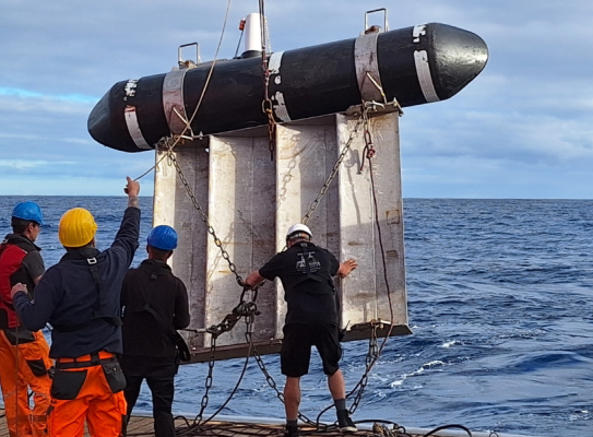
Setting off from Auckland, the team onboard the R/V Sonne deployed 24 Ocean Bottom Seismometers (OBS) – that record seismic signals penetrate deep into the seafloor – on and in the region of Brothers volcano. This was followed by a comprehensive 2D seismic survey of the volcano along with deployment of the GNS magnetomer and two onboard gravimeters to measure magnetic and gravity anomalies in the region.
This work has produced stunning images of the subsurface, and with the work progressing well, the team extended the survey and travelled down to Healy volcano which has produced equally stunning seismic sections.
The 2D seismic survey is expected to produce the greatest detail ever captured of Brothers volcano with a remarkable 5 m spatial resolution inside the volcano, with ~2000 line-km of survey planned.
The voyage
GNS Principal Scientist Dr Cornel de Ronde is co-principal investigator of the joint operation with GEOMAR to survey Brothers volcano to learn of its internal structure offering critical insights into the dynamics of caldera collapse, volcanic cone growth, and the pathways of hydrothermal fluids.
The team onboard the R/V Sonne have performed seismic surveying of the Brothers volcano, with the goal of imaging the internal architecture of the volcano to learn the “plumbing” of its large hydrothermal system and the relationship between caldera collapse and natural hazards such as the associated tsunamis. The voyage hopes to also identify the location and size of the magma chamber that lies beneath the volcano.
-
The R/V Sonne
The team is on board the R/V Sonne (meaning Sun), a high-tech vessel equipped to cover a wide spectrum of ocean research. The Sonne is purpose-built, and clocks in at 118 m long. It can be at sea for 50 days, can accommodate 75 people and has 17 labs. It’s capable of geology, geophysics, biology, biogeochemistry and climate research – all while at sea.
Further seismic surveying of the region
- Additional 2D seismic surveying was performed over Rumble III volcano coupled with magnetics and gravity, as part of a time-series study of this volcano which has suffered several flank collapses in historical times.
- The Sonne also traversed the Kermadec Ridge to the east of New Zealand, mapping the seafloor with multibeam and conducting gravity and magnetic surveys.
-
The team
36 scientists are taking part in the voyage which is a joint operation between the GEOMAR Helmholtz Centre for Ocean Research Kiel of Germany and GNS Science. It is led by Prof. Christian Berndt from GEOMAR, with co-PIs Cornel de Ronde from GNS Science and Gareth Crutchley, also from GEOMAR.
A veritable United Nations is onboard, represented by individuals from Germany, New Zealand, Italy, France, The Netherlands, Switzerland, Scotland, England, Malta and Portugal, and includes a large contingent of students.
-
Voyage update
Co-principal investigator onboard the RV Sonne, Cornel de Ronde provided an update on the recent surveying of Brothers volcano.(external link)