Fault lines to front lines – supporting our Pacific partner’s earthquake response
Vanuatu is still recovering from the M7.3 earthquake that shook the region on 17 December 2024. GNS Science is assisting our Pacific neighbours, providing expert advice integral to the recovery effort.
From the moment the earthquake struck, our experts have been working side-by-side with our Vanuatu neighbours to identify landslide hazards from the earthquake and subsequent aftershocks and assess the impacts on communities and infrastructure.
Critical decisions required
GNS expertise in natural hazard reduction, readiness, response and recovery is guiding local decision makers considering their necessary next steps – like the potential relocation of communities to safer areas and identifying future risk to critical infrastructure, particularly road networks.
Supporting our neighbouring nation's recovery from the devasting earthquake is important, not just for Vanuatu, but to build our own resilience here at home – so when faced by our own challenges our communities are prepared and resilient.
Kicking off remotely from our Lower Hutt office, GNS provided technical assistance to support Vanuatu responders to model and map landslide hazards from the earthquake and subsequent aftershocks. The work included gauging landslide susceptibility, producing runout modelling and ‘hotspot’ identification to assess the impact on communities and infrastructure.
New Zealand Ministry of Foreign Affairs and Trade staff from the High Commission in Port Villa, and from the Humanitarian and Disaster Management Team in Wellington were closely involved and facilitated GNS engagement with the Government of Vanuatu to determine how GNS could best assist.
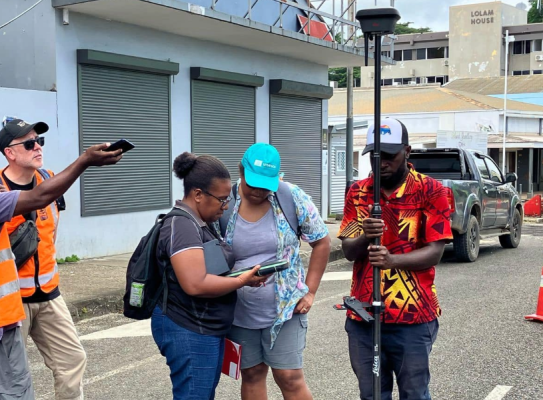
Once in Vanuatu in March, our team conducted drone surveys in priority areas in and around Port Vila and Efate, including the wharf, Blacksands, Klehms Hill, Melemaat and Montmartre. Our team were joined in the field by staff from the Vanuatu Meteorology and Geohazards Department and the Ministry of Lands and Natural Resources, providing an excellent opportunity for mutual knowledge exchange and relationship building.
The on-site work validated and improved our remote scientific analysis and the GNS team provided a valued surge capability resource for the local response team.
We were deployed to assess the current state and provide a comprehensive overview of the risk – that is critical information Vanuatu required to guide its recovery.
Sharing knowledge
On site, GNS experts noted similarities between Port Vila and Christchurch, particularly the building and infrastructure damage, the necessity to demolish and rebuild, and consequences of this for recovery planning in a central business district. Christchurch City Council were also able to share advice of their own recovery and rebuild efforts as Vanuatu follows the New Zealand Building Code.
Levu B Antfalo, Director of the Vanuatu Meteorology and Geohazards Department (VMGD), said the support from GNS following the M7.3 earthquake was not only critical in informing their immediate response and recovery decisions – it also empowered their team with new tools, methods, and confidence to assess complex hazards like landslides and liquefaction.
GNS expertise, paired with the in-country training and collaborative fieldwork, has significantly strengthened VMGD’s technical capacity and preparedness. This kind of partnership is exactly what resilience-building looks like in practice.
-
GNS technical support package
Following delivery of the initial landslide susceptibility and runout hazard maps in January 2025, GNS presented two of four reports to the Government of Vanuatu in April and May 2025. Our technical assistance package focuses on two priority areas:
- Landslide hazard identification and risk assessment
We identified at risk communities and lifeline infrastructure, supporting response and recovery decision-making. The work included identifying safer areas for relocation and current and future risk to infrastructure. It provided additional information to the Vanuatu Government to support their decision-making, such as warnings and evacuation advice for the Port Vila community, response/recovery teams, and tourists. Our tasks included developing landslide hazard footprints for earthquake- and rainfall-induced landslides within the main areas affected by the mainshock.
In addition to landslide hazard, we also worked with the Vanuatu Geology and Mines Unit to assist fault rupture and liquefaction hazard identification and risk assessment. - In-country capability building
In March we worked with the Vanuatu Meteorology and Geohazards Department to add landslide assessment into their portfolio, and held training exercises to boost local capacity in landslide monitoring, hazard analysis, and risk assessment.
- Landslide hazard identification and risk assessment
-
Tell me more about the earthquake
A M7.3 earthquake struck west of Port Vila, Vanuatu, on 17 December. There were several significant aftershocks including a M5.5, which occurred within 24 hours of the mainshock.
The earthquake caused significant casualties, with 14 people losing their lives. Many homes, buildings and vital infrastructure have been severely damaged or destroyed, leaving many families in desperate need according to UNICEF.
The Government of Vanuatu estimated that over 80,000 people were directly affected and declared a 7-day state of emergency starting 18 December.
Extensive damage to buildings and infrastructure included hospitals, roads, water reservoirs, and gas pipes. Hospitals in Port Vila were overwhelmed, and makeshift triage tents were used. Water supply was severely impacted due to damaged reservoirs. Gas leaks posed environmental hazards.
In New Zealand, NEMA advised the public to remain vigilant in beach and marine areas and watch for strong or unusual currents. This was informed by science advice from GNS and the Tsunami Experts Panel.
-
Project acknowledgements
This project was funded by the New Zealand Government’s Ministry of Foreign Affairs and Trade as part of an assistance package following the earthquake. Our team worked closely with the Government of Vanuatu, in particular the Vanuatu Meteorology and Geohazards Department, the Department of Lands, Survey & Records Geology and Mines Unit, and the Vanuatu National Disaster Management Office.
Main image credit: Sheng-Lin Lin