New atlas maps metals and other elements across Aotearoa’s soils
The Geochemical Atlas of Aotearoa New Zealand provides the first national baseline of the concentrations of elements in our near-surface soil, highlighting where human activities have increased heavy metals, and where elements beneficial for soil health are low. This information can help us manage risk and improve our environment.
Soil is a vital foundation for the economic wellbeing of Aotearoa New Zealand, and for our individual and collective wellbeing. It’s important to have an understanding of the chemical variation in soil across the country, and where mitigation of human impacts or enrichment of trace elements might be beneficial.
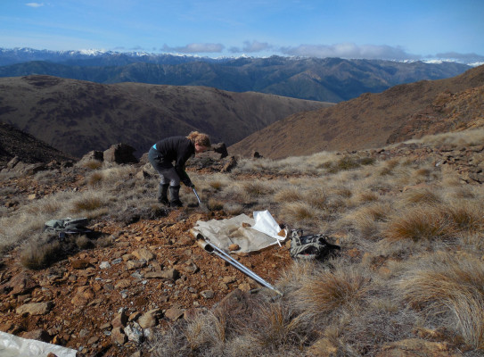
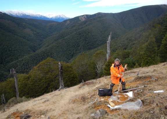
Researchers from GNS Science, Manaaki Whenua – Landcare Research and The University of Auckland have measured the concentrations of 65 different elements in our soils, with analysis drawn from more than 800 samples taken from within the top 30 cm of soil. The atlas presents the results using maps, showing the changes in concentration in each element across the country from Cape Reinga to Rakiura Stewart Island.
“While similar resources exist internationally, the Geochemical Atlas of Aotearoa New Zealand is the first study of this scope and scale for New Zealand," says Mark Rattenbury, GNS Science Geologist.
It’s a foundational resource that will be useful to researchers, policy makers, industry professionals and the public interested in New Zealand’s soil chemistry.
Several of the elements included in the atlas are metals that can be hazardous to human health, including arsenic, boron, cadmium, chromium, copper, mercury, nickel, lead, and zinc. The occurrence of these metals in the soil vary due to differences in underlying rock types, environmental conditions and human influence. The atlas provides a baseline of the concentrations of metals in our soils for the first time nationally – this helps us understand where human activities have changed the naturally occurring concentrations, and allows us to monitor changes and mitigate their potential impact on human health and the environment.
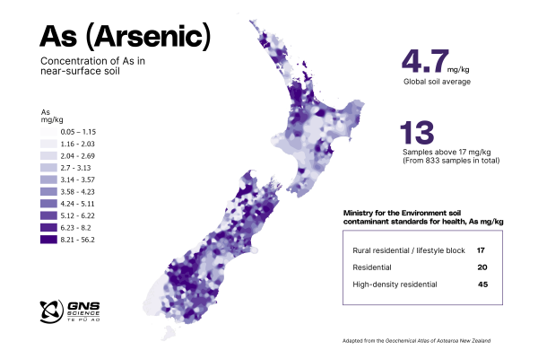
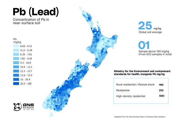
Concentrations of arsenic are elevated in soil in parts of Northland, Coromandel, South Auckland, Waikato, Hawke’s Bay, Nelson, Marlborough and northwestern Otago. Higher concentrations of lead occur through Canterbury and Marlborough, as well as parts of Wellington, Hawke’s Bay, Waikato, Auckland and Northland.
The maps show elevated levels of lead and arsenic in several urban centres. Rattenbury says that it is not unexpected to find elevated levels of these elements in highly populated areas.
“This is a known phenomenon in cities worldwide, with possible sources including pollution from industrial processes, leaded petrol from our past, disposal of fossil fuel residues and household refuse, and the deterioration and removal of lead-containing paints from older houses.”
There are notable elevations of cadmium in Taranaki and Waikato, which is consistent with other studies on the distribution of cadmium across New Zealand and is attributed to long duration of superphosphate fertiliser application.
The Ministry for the Environment (MfE) issues New Zealand’s soil contaminant standards for health. The standards set out the acceptable concentrations of heavy metals in soil, categorised by land use.
A small number of samples (from the total of 833) exceeded the most restrictive threshold – one sample for lead, 13 samples for arsenic, 26 samples for cadmium. However, none of the samples exceeded the MfE threshold applicable to the expected land use at sample locations.
Rattenbury says that the maps cannot to be used to pinpoint element concentrations for individual properties. The wide sample spacings and interpolation technique used to construct the maps only provide relatively low spatial resolution, but provide a good guide for more detailed study.
“The estimated element concentrations are indicative only and how representative the estimates are for any site can only be confirmed with further sampling and analysis.”
“If anyone is interested to find out more about the levels of heavy metals in their backyard, I would encourage them to check out the free soil testing service Soilsafe run by the University of Auckland, that GNS Science helped establish,” says Rattenbury.
Previous studies of soils in Dunedin and Auckland also found samples with higher concentrations of lead and arsenic.
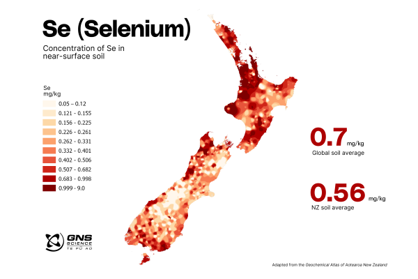
The atlas shows the concentrations of trace elements that are important for land productivity or are essential for human, animal or plant health. For example, selenium is an essential trace element, and the atlas indicates that many New Zealand soils are low in selenium, particularly in the central North Island, Otago, Canterbury and Marlborough. Low concentrations of other essential trace elements, copper and molybdenum are evident along most of the east coast of New Zealand, excluding Napier and Hastings.
“This information helps identify where trace elements may need to be added to enhance productivity or improve the nutritional quality of food crops for livestock and people,” says Jo Cavanagh, Senior Researcher – Soil and Ecosystem Health, Manaaki Whenua – Landcare Research.
GNS Science Environment and Climate Theme Leader Giuseppe Cortese says the atlas is an important addition to the wider work that GNS Science undertakes to quantify the contaminants present in our air, freshwater, ocean and soil, and to understand how these contaminants move through our environment.
“This atlas is a valuable resource for Aotearoa. It provides important information about the location and concentration of key elements so that we can monitor them and manage their movement today. But the data also offer a starting point from which we can explore and model how these elements may move through our environment as the climate changes and land use shifts in the future,” says Cortese.
An urban geochemical atlas for Wellington will be published by GNS Science within the next few months.
-
Heavy metal contamination - health information
Heavy metals and metalloids occur naturally in soil, water and food, and many are essential in small quantities for human health. However, some heavy metals are toxic in certain quantities, and subsequently the Ministry for the Environment has set guidelines (Soil contaminant standards for health Users Guide) for acceptable levels of these substances in New Zealand soils for a variety of different land uses.
For information about the health impacts of lead(external link), arsenic(external link) and soil contamination(external link) visit Health New Zealand Te Whatu Ora.
-
Soilsafe Aotearoa
Soilsafe Aotearoa(external link) is a community science project run by the School of Environment at the University of Auckland. Members of the public can send a sample of their backyard soil for free testing for arsenic, copper, lead and zinc.