
Paul Viskovic Geomodeller
Paul is an experienced technical scientist with skills in 3D surface modelling, database management, seismic data, historical seismology, velocity modelling and low temperature geothermal systems.
View Bio Contact MeUnfortunately you are viewing this website on an outdated browser which does not support the necessary features for us to provide an adequate experience.
Please switch to a modern browser such as latest version of Google Chrome, Mozilla Firefox, Apple Safari or Microsoft Edge.
This collection includes original seismograms recorded by the New Zealand Seismograph Network dating from the 1900s to 2005, including complete collections from several Pacific Island stations, and some stations in Antarctica. This is one of several resources in the Nationally Significant Earthquake Information Database (EID).
Nationally Significant Databases are those datasets and collections registered as important for New Zealand, and as such are supported by long-term government funding.
These maps show the location of the stations and the durations of records. The records are mostly paper seismograms with some film. We have started scanning some of the material. Data can be made available on request.
The map of New Zealand shows the New Zealand Seismograph Network stations and duration of paper records held:
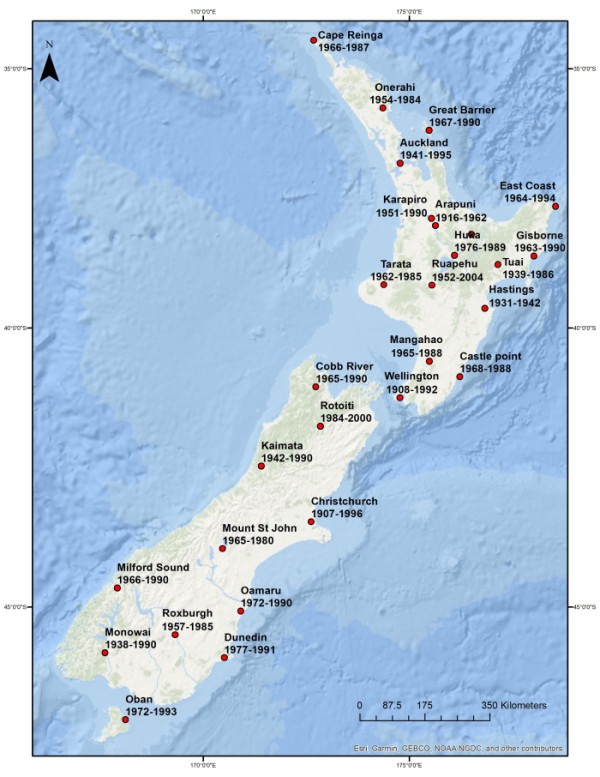
Map showing New Zealand Seismograph Network stations and duration of paper records held. Oban 1972-1993, Monowai 1938-1990, Dunedin 1977-1991, Roxburgh 1957-1985, Milford Sound 1966-1990, Mount St John 1965-1980, Kaimata 1942-1990, Christchurch 1907-1996, Rotoiti 1984-2000, Cobb River 1965-1990, Wellington 1908-1992, Castle Point 1968-1988, Mangahao 1965-1988, Tarata 1962-1985, Ruapehu 1952-1993, Hastings 1931-1942, Tuai 1939-1986, Gisborne 1963-1990, Huka 1976-1989, East Coast 1964-1994, Arapuni 1916-1962, Karapiro 1951-1990, Auckland 1941-1995, Great Barrier 1967-1990, Onerahi 1954-1984, Cape Reinga 1966-1987
The wider map shows locations of Pacific seismograph stations formerly operated by New Zealand and duration of paper records held:
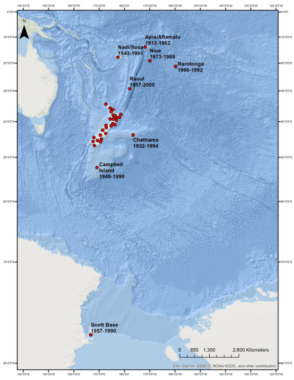
Map showing locations of Pacific seismograph stations formerly operated by New Zealand and duration of paper records held. Scott Base 1957- 1990, Campbell Island 1949-1990, Chathams Island 1932-1994, Raoul 1957-2000, Rarotonga 1966-1992, Niue 1973-1988, Nadi/Suva 1943-1991 , Apia/Afiamalu 1913-1962.
Paul is an experienced technical scientist with skills in 3D surface modelling, database management, seismic data, historical seismology, velocity modelling and low temperature geothermal systems.
View Bio Contact Me